This item has been sold, but you can get on the Waitlist to be notified if another example becomes available, or purchase a digital scan.
1887 Bird's Eye View Map of South Natick, Massachusetts
SouthNatickView-unknown-1887$900.00

Title
South Natick Massachusetts.
1887 (undated) 16 x 23.375 in (40.64 x 59.3725 cm)
1887 (undated) 16 x 23.375 in (40.64 x 59.3725 cm)
Description
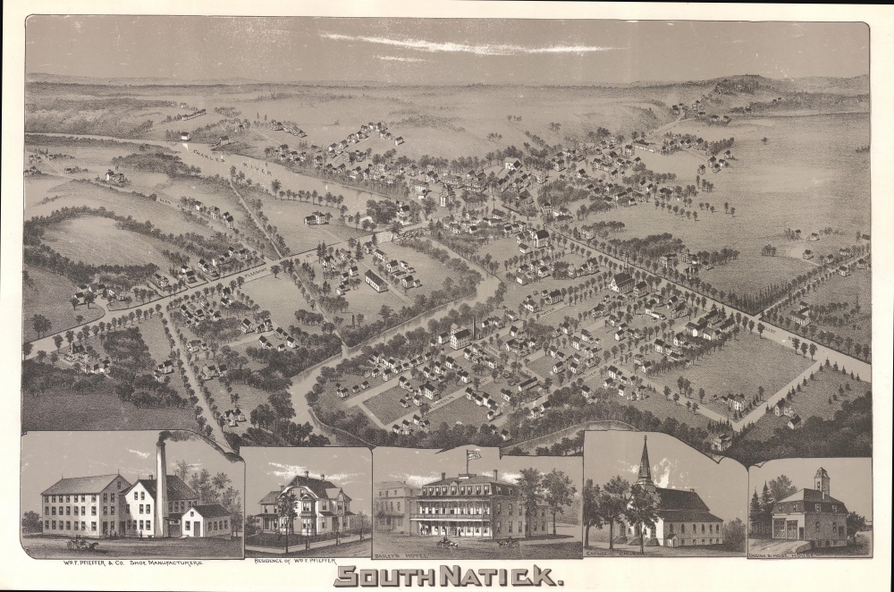
This is a rare 1887 lithograph bird's-eye view of South Natick, Massachusetts, by an unknown artist.
City views were being produced in the United States as early as the 1830s, but the genre exploded after the American Civil War (1861 - 1865). Bridging the gap between maps and pictures, most 19th century American bird's-eye views presented cities to the public from highpoints. Some were imagined, but others were drawn from hot-air balloons or nearby hills. The presentation, combining high elevation, commercial interest, and new printing technology created a uniquely American artform, as described by historian Donald Karshan,
A Closer Look
The view looks northeast on South Natick from a fictional high point above Elm Bank. River Street, South Lincoln Street, Water Street, and the Charles River occupy the foreground. The major arteries are labeled: Pleasant Street, Eliot Street, and Union Street. Five smaller views are included below: William F. Pfieffer and Company, William Pfieffer's residence, Bailey's Hotel, the Catholic church, and the Engine and Hose House. With the help of these smaller views one can identify the factory of William M. Pfieffer, the Catholic church, and Bailey's Hotel within the larger view.American Bird's-Eye City Views
The Bird's-Eye view industry emerged in the United States in the middle part of the 19th century and coincided with the commercial development of lithographic printing. Before the rise of lithography, the ability to own and display artwork in the home was largely limited to the extremely wealthy, but the advent of lithographic printing made it possible for everyone to own visually striking artwork. A robust trade developed in portraits of political leaders, allegorical and religious images, and city views.City views were being produced in the United States as early as the 1830s, but the genre exploded after the American Civil War (1861 - 1865). Bridging the gap between maps and pictures, most 19th century American bird's-eye views presented cities to the public from highpoints. Some were imagined, but others were drawn from hot-air balloons or nearby hills. The presentation, combining high elevation, commercial interest, and new printing technology created a uniquely American artform, as described by historian Donald Karshan,
Some print connoisseurs believe that it was only with the advent of the full-blown city-view lithograph that American printmaking reached its first plateau of originality, making a historical contribution to the graphic arts. They cite the differences between the European city-view prints and the expansive American version that reflects a new land and a new attitude toward the land.The vogue for bird's-eye city views lasted from about 1845 to 1920, during which period some 2,400 cities were thus portrayed, some multiple times. Although views were produced in many urban centers, the nexus of view production in the United States was Milwaukee, Wisconsin. The major American viewmakers were Stoner, Wellge, Bailey, Fowler, Hill Ruger, Koch, Burleigh, Norris, and Morse, among others.
Publication History and Census
This view was created and published in 1887. We are aware of only one other example, currently in private hands. Rare.Condition
Good. Some surface abrasions. Bottom margin may be trimmed.