This item has been sold, but you can get on the Waitlist to be notified if another example becomes available, or purchase a digital scan.
1911 Tampa Land Co. Map of Tampa SE: Palm River-Clair Mel, Riverview
SouthTampaFlorida-knight-1911$750.00

Title
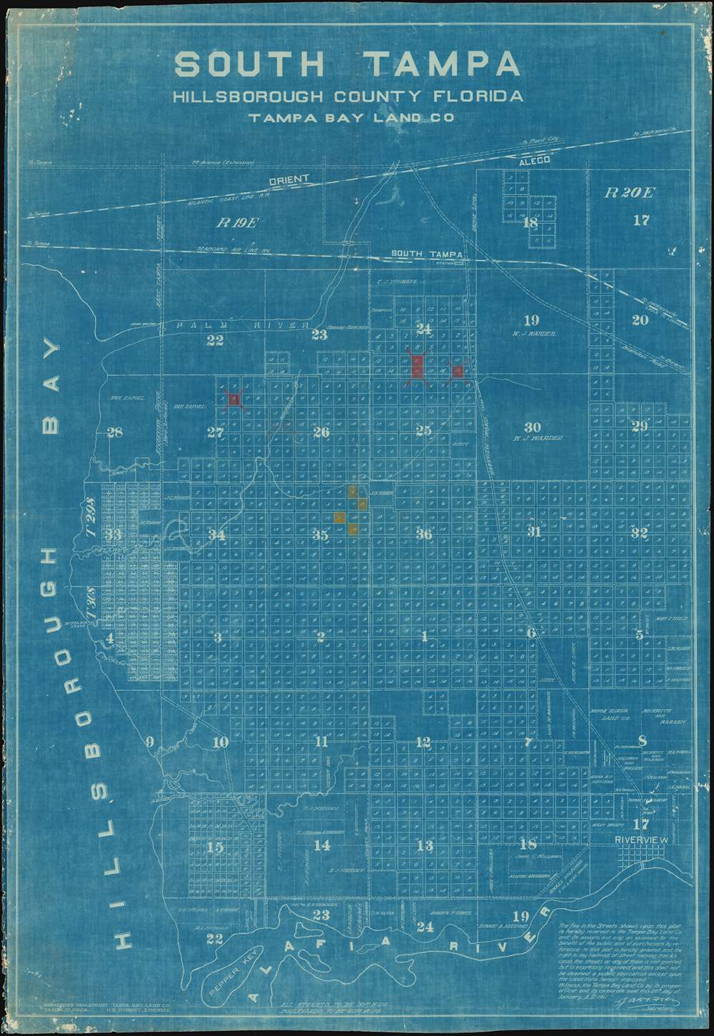
South Tampa Hillsborough County Florida Tampa Bay Land Co.
1911 (dated) 43.5 x 30 in (110.49 x 76.2 cm) 1 : 15000
1911 (dated) 43.5 x 30 in (110.49 x 76.2 cm) 1 : 15000
Description
This is a one of a kind 1911 cyanotype or blueprint map of Palm River-Clair Mel, Progress Village, Riverview, southeast of Tampa, Florida. While somewhat confusingly titled 'South Tampa', the map in effect covers the lands between the Palm River and the Alafia River, from Hillsborough Bay to Riverview, including Palm River-Clair Mel, Progress Village, Riverview, and 'East Tampa.' It was compiled by H.R. Knight, an engineer working with the Tampa Bay Land Company in the early 20th century. Since this may is a cyanotype, which is limited to tiny production numbers, we can surmise that it is a working plan used by Tampa Bay Land Company engineers to actively plan infrastructure and development, not a mass-produced sales tool. Some lots are highlighted in colored manuscript for unclear reasons.… today crops are growing on more than two score plats of ground, chicken ranches have been established, the tract is dotted with homes in cottage and bungalow style, and the proposition looks prosperous from every standpoint. In the subsequent years, the Land Company built roads, sold lots, planned parks, and set aside land for major public transit projects. None of these big plans would reach ultimate fruition. The Tampa Bay Land Company began its decline in the late 1920s, when the Great Depression and the collapse of the Florida real estate bubble pushed it into insolvency.
Tampa Bay Land Company
The Tampa Bay Land Company was charted in Florida around 1906, and by 1910 was a major force driving the development of Tampa's surrounding communities. The firm prospered by leveraging interest in Florida's timber and agricultural resources to ride the 1910-1925 Florida land boom. The firm had two major areas of development, Keystone Park, and, as here, what it called 'South Tampa, the only city-suburban colony in Florida'. 'South Tampa' was offered for sale from December of 1909. A pamphlet issued by the Tampa Bay Land Company at that time advertises,Cyanotype: Why so Blue?
Cyanotype is a photo-reprographic technique developed in 1842 by the British astronomer John Herschel (1792 - 1871). Sometimes called a 'sunprint', the technique employs a solution of ferric ammonium citrate and potassium ferricyanide, which painted on white paper or cloth, reacts when exposed to sunlight to dye the object a brilliant blue. Areas blocked from ultraviolet exposure remain undyed and white. Herschel developed the technique to reproduce his astronomical notes, but others quickly realized that any object capable of blocking light could be used to quickly and easily create a cyanotype image. By the late 19th century the process became popular with designers, military, architects, and engineers (blueprints), who used the cheap an effective technique to quickly and exactly reproduce images in the field. Cyanotyping is limited in that only a single copy can be made at one time, so it was only practical for short-term field work. It is also of note that cyanotypes remain extremely reactive to light and, over time, fade or degrade, making them extremely ephemeral. The process fell out of fashion in most places by the 1920s, but remains in use in some parts of the world, such as India and Nepal, to this day.Publication History and Census
This map was prepared by Harry R. Knight for the Tampa Bay Land Company. The present map is the only known surviving example.Cartographer
Harry R. Knight (August 9, 1882 - June, 1953) was a civil and municipal engineer active in Florida with the Tampa Land Company from roughly 1906 to 1917. Knight was born in Akron Ohio, graduated in 1900 from the University of Florida, and, and in 1902 from the Rose Polytechnic institute in Terre Haute, Indiana. From 1905 to 1907, he served in the Georgia Naval reserve. Simultaneously, Knight worked in the railroad industry until about 1907, when he took a position as a civil engineer with the Tampa Bay Development Company. Under the TBD Company, Knight was responsible for the layout of the town of Keystone, Florida, and for similar work in the firms 'South Tampa' development - roughly comprising the lands between the Palm River and the Alafia River, from Hillsborough Bay to Riverview, including Palm River-Clair Mel, Progress Village, Riverview, and 'East Tampa.' He was partially paid for his work in land, and in 1917 some acreage was transferred form the Tampa Bay Land Company to his name, after which he is identified in some news articles as a 'farmer.' Towards the end of World War I (1914 - 1918), on July 30, 1918, Knight was commissioned as a 1st Lieutenant and served in France with the 116th Engineers, American Expeditionary Force until March 12 of 1918. Knight retired to Norfolk, VA, where he died in 1953. More by this mapmaker...
Condition
Good. Minor edge wear. Verso repair of minor tear, upper left.