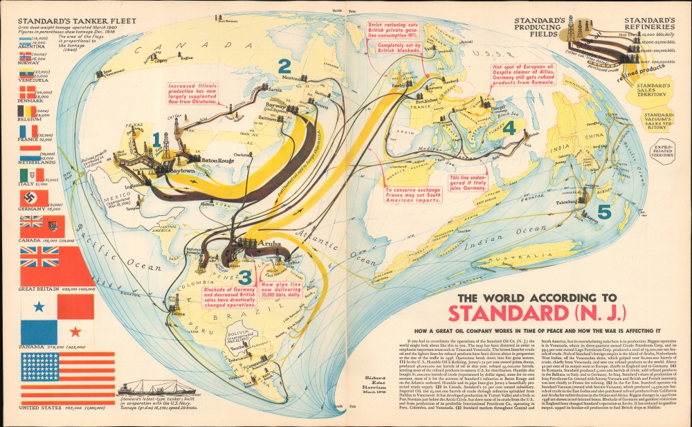
This is a May 1940 Richard Edes Harrison map of the world, illustrating the international operations of Standard Oil and its partners in the opening year of the Second World War and the oil corporation's continuance of trade with all combatants.
A Closer Look
Harrison has chosen a unique projection, distorted to emphasize Standard's oil-producing regions (primarily in Texas and Venezuela) and the oil-consuming areas of Europe. Arrows in dark brown indicate the flow of crude oil, while pale brown lines trace the flow of refined products like gasoline and fuel oil. The spheres of influence of Standard Oil in the west and Standard-Vacuum (the joint venture of Standard Oil and Socony-Vacuum Oil) in the east are shaded yellow. The bulk of the information on the map portrays Standard Oil's trade as of 1938; the red, boxed text indicates changes brought on by the onset of war, as of Spring 1940. A dense, explanatory text fills the lower right corner of the map. Along the left border of the map, the size of Standard Oil's tanker fleet worldwide is enumerated, showing its change in size and distribution between 1938 and 1940; it is divided between the various nations where the ships are registered.Oil to the Axis
Superficially, the map shows some impact of the war on Standard's shipping of oil to Germany: most prominently, the shipments of refined oil from Aruba to Hamburg are described as being 'completely cut by British blockade.' Based on this map, it might be assumed that Germany's sole remaining fuel source would be the Ploesti fields in Rumania. It is telling, however, that between 1938 and 1940, the portion of Standard Oil's fleet registered to Nazi Germany would more than double, from 31000 tons in 1938 to 76000 tons in 1940. While refined fuel from Aruba appeared stopped by the blockade, crude oil via Trinidad is still shown to be passing from South American fields to Germany, a channel which appears to have been expanding via a 'New pipeline now delivering 35,000 (barrels) daily' added since 1938.
Expectations that the entrance of the United States into the war in 1941 would result in a change in Standard Oil's practices lead to disappointment. Standard would continue to sell oil to Germany throughout the war, shipping via ostensibly neutral Spain. In 1944, some fifty thousand tons of American oil would reach Germany. This accompanied Standard Oil's collusion with I.G. Farben and other Nazi German companies to block American production of synthetic rubber, magnesium, and tungsten, up to and during the war.Nationalized Oil
Standard Oil was not always able to continue business in the face of political change. Standard had held a major oil concession in Bolivia beginning in 1921. After the 1932-35 Chaco War (fought between Paraguay and Bolivia over land believed to contain oil reserves), Standard would be the sole exploiter of Bolivian oil. Following their humiliating defeat in the war, Bolivia (fueled by the belief that Standard had provoked the conflict) nationalized the oil industry and expropriated Standard's holdings there in 1937. In 1938, Mexico nationalized its oil industry: siding with striking oil workers, President Lázaro Cárdenas expropriated foreign-owned oil companies, reorganizing them into the Mexican-owned Pemex. These two expropriations are noted and dated on the map.
Standard Oil New Jersey would eventually become Exxon; Socony-Vacuum would become Mobil, and both would join in 1999 to form ExxonMobil.Publication History and Census
Though dated March 1940, this map appeared in only one edition, in the May 1940 issue of Fortune Magazine. The separate map is neglected in institutional collections.
Cartographer
Richard Edes Harrison (1902 - January 5, 1994) was an American cartographer and cartoonist active in the middle part of the 20th century. Harrison is credited with redefining cartography, especially journalistic cartography, by employing spherical perspective, bold shading, and graphic design to both make maps more publicly accessible and give them an artistic dimension. Harrison was born in Baltimore and studied design at Yale, graduating in 1923, before relocating to New York City at the height of the Great Depression. He made ends meet through industrial design work, creating everything from bottles to ashtrays. His first foray into the cartographic world was a fill-in job at Fortune magazine. The editors at Fortune must have admired his work for it launched a long-standing collaboration. His work, doubtless inspired by the age of air travel, became exceptionally popular during World War II, where his unique approach and political charged subject matter illustrated the seats of war with exceptional poignancy and clarity. After the war, Harrison continued to produce maps from his base in New York City. In his spare time he was an avid ornithologist and was commonly seen in Central Park in search of rare bird sightings. More by this mapmaker...
Very good. Printed to two separate sheets; joined.
Rumsey 9882. Not in OCLC.