This item has been sold, but you can get on the Waitlist to be notified if another example becomes available, or purchase a digital scan.

1705 Renneville Map of the Strait of Magellan, Tierra del Feugo

StraitsofMagellan-renneville-1705
$375.00
Typus Freti Magellanici quod Giorguis Spilbergius cum classe lustgravit. - Main View
Processing...

1705 Renneville Map of the Strait of Magellan, Tierra del Feugo

StraitsofMagellan-renneville-1705

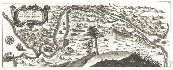
Rare highly decorative map of the Strait of Magellan showing Spilbergen's route.

Title


Typus Freti Magellanici quod Giorguis Spilbergius cum classe lustgravit.
  1705 (undated)     5.5 x 14 in (13.97 x 35.56 cm)     1 : 3500000

Description


A very rare and highly decorative map of the Strait of Magellan published by René-Auguste-Constantin de Renneville to illustrate the Joris van Spilbergen's 1615 navigation through the strait. The map is oriented to the southwest, with northeast at the bottom of the page. The map attempt to illustrate not only the treacherous layout the strait, but Spilbergen's experience within. The map shows one ship engulfed in flames, the result of a mutiny on the eastern entrance of the strait. Five additional ship meanwhile make their way through the strait. Other illustrations show indigenous huts. The scenery, while appropriately mountainous is also deceptively lush and tropical with jackfruit and palm trees making a striking contrast to what we know of the region today. Cartographically it is derived from a similar map issued in De Bry's Grandes Voyages.

Cartographer


René Auguste Constantin de Renneville (October 9, 1650 - March 13, 1723), was a French Protestant scholar and historian. He was born at Caen, but because of his Protestant faith, Renneville fled France for the more tolerant Netherlands in 1699. On his return three years later he was denounced as a spy and imprisoned in the Bastille, where he remained until 1713. Renneville was freed through the intercession of Queen Anne, and made his way to England. There he wrote his Histoire de la Bastille, most likely his most significant work. From a cartographic perspective, however, his other important work, Recueil des voyages qui ont servi a l'etablissement de la Compagnie des Indes Orientales aux Provinces Unies is far more significant. At the time of his death in 1723 Renneville was a major of artillery in the service of the elector of Hesse. More by this mapmaker...

Source


Renneville, Constantin de, Recueil des voyages qui ont servi a l'établissement de la Compagnie des Indes Orientales aux Provinces Unies, 1705.    

Condition


Good. Repair tear in the lower right quadrant. Crisp dark impression.