1823 Senefelder Map of Strasbourg, France
Strasbourg-senefelder-1823$950.00
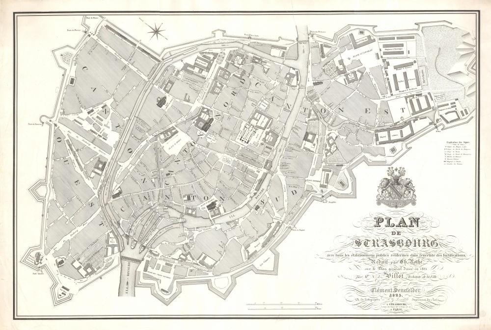


Title
Plan de Strasbourg avec tous les établissemens publics renfermés dans l'enceinte des fortifications, réduit par Ch. Rothé sur le plan général dressé en 1821 par Mr. N. J. Villot, architecte de la ville.
1823 (dated) 22 x 32.75 in (55.88 x 83.185 cm) 1 : 3126
1823 (dated) 22 x 32.75 in (55.88 x 83.185 cm) 1 : 3126
Description
A rare 1823 lithograph map of Strasbourg, France, issued by Clément Senefelder, the brother Alois Senefelder, inventor of lithography. It captures Strasbourg during a time of urban renewal in the wake of the Napoleonic Wars and on the cusp of the Industrial Revolution. This is one of the earliest examples of lithography applied to cartography.
When this map and the precursor Villot plan were issued, Strasbourg was emerging from the violence of the Napoleonic Wars (1803 - 1815). Much of the city had to be renovated or fully reconstructed. The wars significantly impacted the city, as Strasbourg was a key military garrison that saw both French and Allied forces pass through its streets - more often than not, leaving destruction in their wake. Under Bourbon Restoration King Louis XVIII, both France and Strasbourg were struggling to stabilize and rebuild both infrastructure and commerce. At the same time, Strasbourg was beginning to see evidence of industrialization and modernization by being increasingly linked to regional economic and transportation infrastructures.
A Closer Look
Oriented to the northeast, this meticulously detailed map captures the fortified center of Strasbourg. Streets are named, along with important squares and buildings. Individual lots are indicated tentatively. The map is derived from a large-scale map of Strasbourg composed in 1821 by Jean-Nicolas Villot, the city architect of Strasbourg. Accordingly, some buildings on which Villot worked, including the theater and cathedral, are rendered ichnographically - meaning we can see the layout of their interiors. The city's bold fortifications, designed by Vauban in the 17th century, are evident, underscoring its military and strategic significance.When this map and the precursor Villot plan were issued, Strasbourg was emerging from the violence of the Napoleonic Wars (1803 - 1815). Much of the city had to be renovated or fully reconstructed. The wars significantly impacted the city, as Strasbourg was a key military garrison that saw both French and Allied forces pass through its streets - more often than not, leaving destruction in their wake. Under Bourbon Restoration King Louis XVIII, both France and Strasbourg were struggling to stabilize and rebuild both infrastructure and commerce. At the same time, Strasbourg was beginning to see evidence of industrialization and modernization by being increasingly linked to regional economic and transportation infrastructures.
Publication History and Census
This map was published in 1823 by Clemens (Clément) Senefelder, brother and partner of Alois Senefelder, inventor of lithography. It is a reduction of the large-scale 1821 Villot plan, compiled by Charles Rothé - a somewhat elusive figure. It was printed by Senefelder and François Georges Levrault of Strasbourg. The piece is rare on the private market, but we see examples in 2-3 European collections.CartographerS
Clemens Joseph Johannes Senefelder (April 5, 1788 - April 18, 1833) was a German lithographer, artist, and actor active in Munich in the early 19th century. Clemens was the brother and partner of Johann Alois Senefelder (1771 - 1834), inventor of lithography. As he worked extensively as a lithographer with his brother Alois, he is often erroneously assumed to be Alois' son, this is definitively not the case (c.f. CERL #cnp01380853). Many of the earliest lithographic images are attributed to Clemens, who worked hand in hand with Alois in developing the new printing technique. Alois Senefelder went on to great success, but his younger brothers and sister, also lithographers, struggled in Munich, where as late as 1799 they made ends meet by printing letter sheets which they sold in the evenings at inns. Apparently of all the Senefelder family, Clemens was the most talented artistically, producing several meticulously engraved pieces, including a large plan of Strasbourg. Later he found a job as secretary in the Ministry of Foreign Affairs. He was once taken into custody from his hotel in Vienna because of a careless public remark he made in a guest house that everything could be counterfeited, even all bills of exchange and bank notes, and so deceptively that it was impossible to distinguish fake from real. He died in Munich in 1833. More by this mapmaker...
Jean-Nicolas Villot (May 14, 1782 - April 7, 1857) was a French architect active in Strasbourg. Villot was born in Dijon, Côte-d'Or. From 1812 - 1843, he was the official architect of the City of Strasbourg. His work is typical of the post-neoclassical style advocated at the École des Beaux-Arts in Paris, where he studied. His work includes renovations of many major Strasbourg monuments. Much of his unique work has since been demolished. In 1821, he completed a large-scale general map of Strasbourg. He died in Strasbourg in 1857. Learn More...
François Georges Levrault (March 21, 1722 - April 22, 1798) was a French protestant printer and bookseller active in Strasbourg in the late 18th century. Levrault was bore in Ogéville, France. His parents died at a young age, but he was taken in by a local priest who raised and educated him. In 1742, he entered the printing business of Jean Robert Joseph Christmann (1704 - 1761). He married Christmann's daughter, Maria Anna Elénora Christman (1737 - 1788), in 1761. In 1769, he was made a partner in the firm, and in 1772, after his brother-in-law François Robert Adrien Christmann (1728 - 1771) died, he became the full owner. In 1786, he acquired the Abreschwiller Paper Mill. By this time, his operation was the largest and most important printing shop in Eastern France. Learn More...
Condition
Good. Minor margin toning. Closed tear extending into the map from top margin near Ill River.
References
Bibliothèque nationale de France, département Cartes et plans, GE C-10488. OCLC 1177199414, 800510504.