This item has been sold, but you can get on the Waitlist to be notified if another example becomes available.
1983 Rockwell International STS-8 Space Shuttle Landing Maps
STS8Landing-rockwellinter-1983$300.00


Title
Deorbit and Entry Track. Entry Ground Track. Descent Over California. STS-8 Approach and Landing Runway 22 Edwards Air Force Base, Calif.
1983 (undated) 7.5 x 9.5 in (19.05 x 24.13 cm)
1983 (undated) 7.5 x 9.5 in (19.05 x 24.13 cm)
Description
This is a set of 4 1983 maps created by Rockwell International illustrating the Space Shuttle Challenger's entry and landing to conclude STS-8.
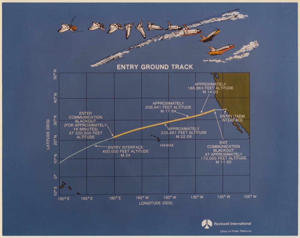
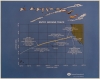
The second image focuses on the entry track and plots it over a map of the Pacific. It marks changes in altitude from 400,000 feet to 170,000 feet, and yellow highlights the communication blackout portion of entry, from 320,000 feet to 170,000 feet.
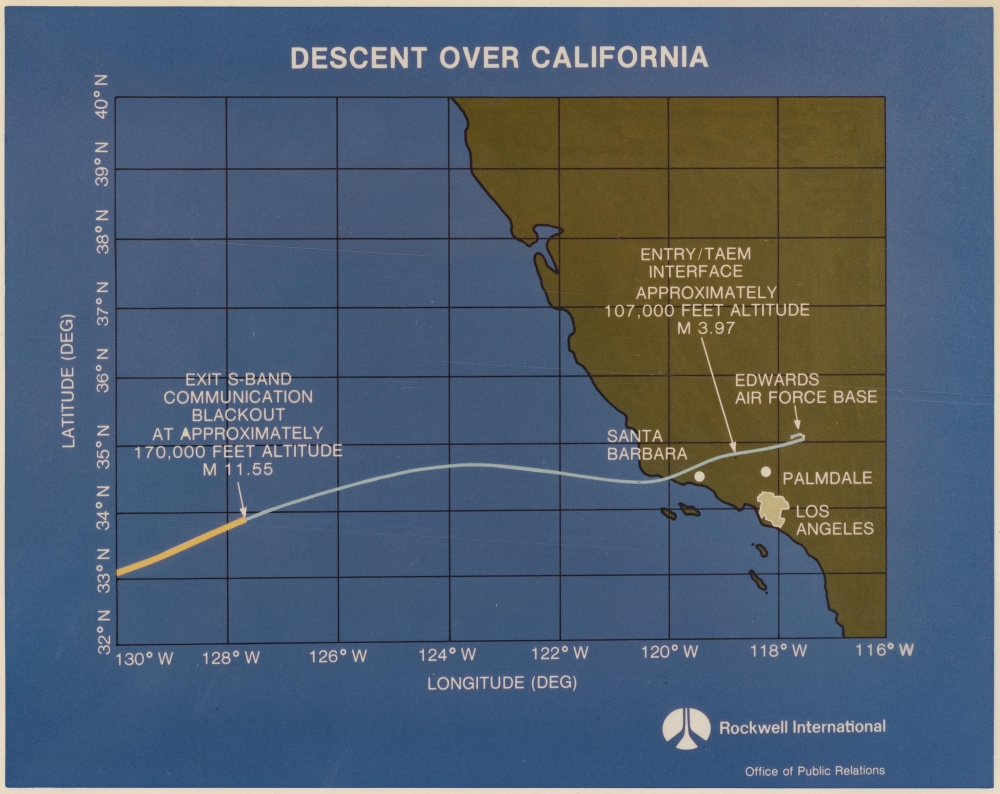
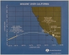
The third image depicts Challenger's descent from the end of the communication blackout phase to its landing at Edwards Air Force Base in California. Santa Barbara, Palmdale, and Los Angeles are labeled.
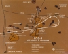
The final map illustrates Challenger's final approach to Edwards Air Force Base, detailing the final 5 minutes of the mission. A white line follows Challenger's projected flight path and notes that 4.5 minutes before landing, it would still be flying at 53,000 feet. Four points on the line mark the preflare 1/2 nautical mile before landing, when the command to lower the landing gear would be given (19 seconds before landing), when the landing gear should be down and locked (10 seconds before landing), and touchdown. Other locations marked on the map include Rosamond Lake (another airfield), several hills and buttes in the Mojave Desert, and Rosamond and Boron, California.
A Closer Look
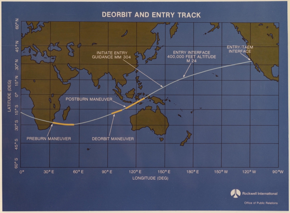
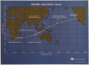
The most general image illustrates the entire deorbit and entry track from above Africa to Challenger's scheduled landing in California. Yellow highlights the preburn maneuver, the deorbit maneuver, and the postburn maneuver. The point where the crew would initiate entry guidance, when the shuttle would reach 400,000 feet, and the Entry/TAEM interface point off the California coast are also marked.The second image focuses on the entry track and plots it over a map of the Pacific. It marks changes in altitude from 400,000 feet to 170,000 feet, and yellow highlights the communication blackout portion of entry, from 320,000 feet to 170,000 feet.
The third image depicts Challenger's descent from the end of the communication blackout phase to its landing at Edwards Air Force Base in California. Santa Barbara, Palmdale, and Los Angeles are labeled.
The final map illustrates Challenger's final approach to Edwards Air Force Base, detailing the final 5 minutes of the mission. A white line follows Challenger's projected flight path and notes that 4.5 minutes before landing, it would still be flying at 53,000 feet. Four points on the line mark the preflare 1/2 nautical mile before landing, when the command to lower the landing gear would be given (19 seconds before landing), when the landing gear should be down and locked (10 seconds before landing), and touchdown. Other locations marked on the map include Rosamond Lake (another airfield), several hills and buttes in the Mojave Desert, and Rosamond and Boron, California.
STS-8 and the Space Shuttle Challenger
STS-8 launched on August 30, 1983, and was the 8th Space Shuttle mission. It was Space Shuttle Challenger's third flight. STS-8 was notable for being the first night launch and night landing for the Space Shuttle program. Challenger deployed an Indian communications and weather observation satellite called INSAT-1B, tested the shuttle's Canadarm, and conducted various scientific experiments. STS-8 was also notable because it was the first time an African American flew in space, Mission Specialist Guion Bluford. Challenger flew another 7 missions and was tragically lost on January 28, 1986, when it broke up 73 seconds after liftoff.Publication History and Census
These 4 maps/diagrams were created, published, and distributed by Rockwell International (Boeing) in 1983. This is the only known cataloged example of any of these pieces.Condition
Excellent. Printed on glossy photo paper.