1875 Fuchs View of Charlotte Amalie, St. Thomas
StThomas-fuchscharles-1875$300.00

Title
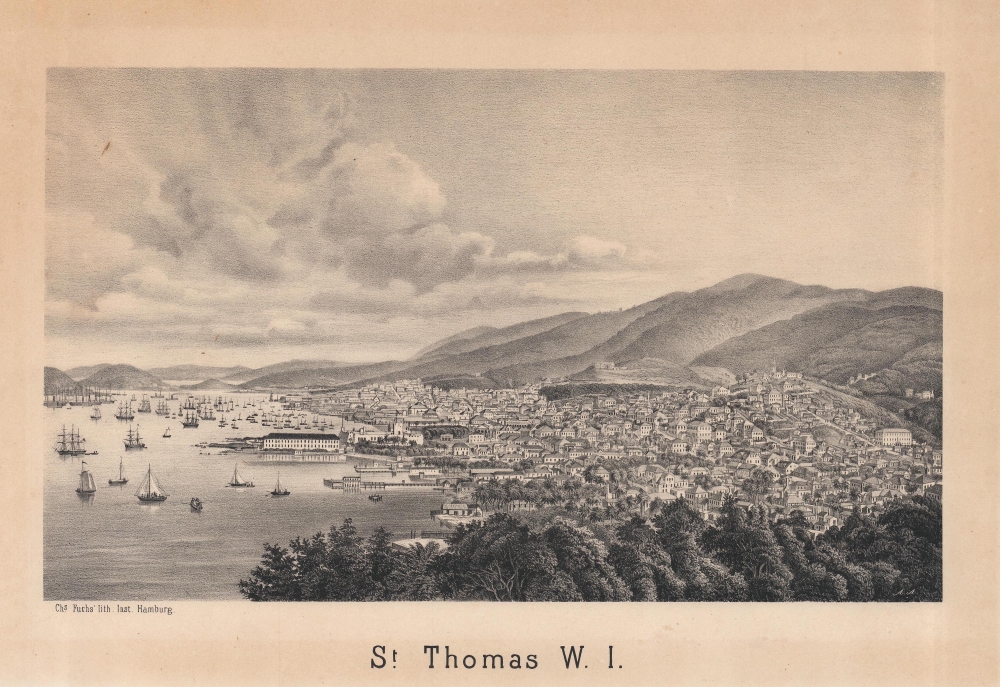
St. Thomas W. I.
1875 (undated) 8.5 x 12.5 in (21.59 x 31.75 cm)
1875 (undated) 8.5 x 12.5 in (21.59 x 31.75 cm)
Description
A scarce, unrecorded c.1875 view of the city of Charlotte Amalie, St. Thomas, U.S. Virgin Islands (then part of the Danish West Indies), printed by Charles Fuchs in Hamburg.
A Closer Look
Oriented towards the west, this view covers the city of Charlotte Amalie, today the capital of the U.S. Virgin Islands. The fortress at left-center is Fort Christian, built in the 1670s. The more modern structure to its left was a barracks for the Danish police, which today serves as the Legislative Building of the U.S. Virgin Islands. The fort and legislative building are key parts of the Charlotte Amalie Historic District, which contains several important historic buildings, including the St. Thomas Synagogue, built in 1796, the second-oldest synagogue in the United States. On the other hand, the view appears to have deliberately excluded Blackbeard's and Bluebeard's Castles, defensive towers (not really deserving of the name 'castle') built by the Danes which have a tenuous connection to the famed pirates.Danish America
Like many Caribbean islands, the U.S. Virgin Islands passed through a series of European colonial empires in the early modern period. Following Christopher Columbus and the Spanish, the French, English, Dutch, and even the Knights of Malta each made an appearance, leaving a permanent mark on the islands, in their placenames, if nothing else. Between the late 17th and early 18th century, the Danish gained control of St. Thomas and St. John and purchased St. Croix from France. The Danish administration of the colonies followed a similar pattern as other European Caribbean colonies, with sugar plantations worked by enslaved Africans and their descendants. In the mid-19th century, following several slave revolts and amid the broader emancipation movement, slavery was abolished, though strict labor laws remained to maintain the racial and labor hierarchy. Natural disasters also reduced the profitability of the islands for Denmark. By the late 1860s, the potential sale of the islands to the United States appeared to be a neat solution for both countries. However, it would take fifty years for agreements to be reached and then approved by the Danish Parliament and voters; ultimately, the threat of Germany's use of the islands in the First World War finally prompted the sale's approval in 1917.Publication History and Census
This view was printed by Charles Fuchs' Lithographisches Institut in Hamburg. It is undated, but the inclusion of the barracks (legislative building) indicates a date of 1874 or later. The view is unrecorded in institutional collections and has no known history on the market. Fuchs also produced a view of the St. Thomas synagogue ('View of the Synagogue in the Island of St. Thomas W.I.,' held by the College of Charleston William A. Rosenthall Judaica Collection), and the two works may be related. The use of English in the titles of both works is interesting, suggesting the works' intended audience.Cartographer
Charles Fuchs (October 28, 1803 - March 5, 1874), also known as Carl Friedrich Fuchs, was a German lithographer based in Hamburg. Born in Prague, he spent his childhood in Hamburg and then lived in Bordeaux and Strasbourg, training for a military career before switching to lithography. He trained with the father-son team Frédéric Sigismond Simon and Frédéric Emile Simon, and he married the former's daughter (upon which Fuchs began to use the French version of his given name). Fuchs opened his own lithographic print shop (institut) in Hamburg around 1832. He also ventured into photography and was known for his technique of using chromolithography to print color onto photographs. After Fuchs' death, his print shop continued to operate, led by his son-in-law, until the early 20th century. More by this mapmaker...
Condition
Good. 1.5 inch tear on left border professionally repaired. Wear and soiling along edge. Uneven toning in margin.