This item has been sold, but you can get on the Waitlist to be notified if another example becomes available, or purchase a digital scan.
1588 Ruscelli and Ptolemy Map of Southeast Asia
TabulaAsiaeXI-ruscelli-1599$125.00

Title
Tabula Asiae XI.
1599 (undated) 8 x 10.25 in (20.32 x 26.035 cm) 1 : 32000000
1599 (undated) 8 x 10.25 in (20.32 x 26.035 cm) 1 : 32000000
Description
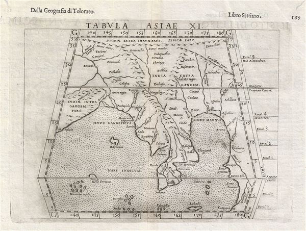
This is an uncommon 1588 Ptolemaic map of Southeast Asia and the Malay Peninsula issued for Girolamo Ruscelli's Italian edition of the Geografia di Tolomeo. Cartographically Ruscelli based this map on interpretations of Claudius Ptolemy's Geographica by Bernard Sylvanus and Sebastian Munster.
Although somewhat difficult to understand in the context of modern geography, this map rangers from the Ganges River in India east to cover all of Thailand, Burma, Vietnam and the China Sea, it extends southward to the tip of the Malay Peninsula, and north to the Himalayas. The Ganges can be clearly identified. To the east of this river the Kingdom of Anrea Regio appears to correspond to Burma. Anyone admiring the golden monuments of modern Burma would have no trouble understanding the name, Anrea Regio, which roughly translates to 'Kingdom of Gold.' Following the shore southwards we come to a gulf or bay identified as Sinus Sabarac, most likely the modern day Gulf of Martaban. Across the narrow isthmus, another gulf, the Sinus Perimulic, would therefore be the Gulf of Thailand. In Malaya itself the Chirsonaie Fleuve, no doubt refers to Cheronesus, an archaic name for the region. The city of Sabana is located roughly where Singapore is today though some speculate that the island that it rests on could only be Sumatra. The mountain range running down the middle of the region correctly corresponds to the mountainous divide separating modern day Thailand from Burma. Ptolemy refers to this region as
This map's most intriguing element is the southward extension of land running along the eastern edge of the map and extending beyond the border. This landmass reflects speculation, inspired by Ptolemy, that the Indian Ocean was landlocked. It was believed that this landmass extended far southwards before turning westward and connecting with eastern Africa. Though the exploits of Vasco de Gama and Magellan had proven that the Indian Ocean was not fully land locked, it was believed that a large tract of land, possibly even America, attached to Asia west of Malaya or the Cheronesus. Thus the 'Great Promontory' or 'Dragon's Tail' that appeared on many maps of this region well into the 16th century. The City of Cattigara, located here in the bottom right corner of the map, is cited by Ptolemy as southernmost known point. There has been considerable debate about the true location of Cattigara, certainly Magellan and the other great navigators failed to identify it, with some attaching the name to Hanoi or South China and others placing it on the shores of South America. Be as it may, the Ptolemaic model retained a great deal of influence well into the 16th century until Portuguese and Dutch navigators more fully explored the region.
A fine, collectable, and early piece essential for any serious collection focused on the cartographic emergence of Southeast Asia in European maps. Published in Girolamo Ruscelli's Italian 1588 edition of the Geografia di Tolomeo.
Although somewhat difficult to understand in the context of modern geography, this map rangers from the Ganges River in India east to cover all of Thailand, Burma, Vietnam and the China Sea, it extends southward to the tip of the Malay Peninsula, and north to the Himalayas. The Ganges can be clearly identified. To the east of this river the Kingdom of Anrea Regio appears to correspond to Burma. Anyone admiring the golden monuments of modern Burma would have no trouble understanding the name, Anrea Regio, which roughly translates to 'Kingdom of Gold.' Following the shore southwards we come to a gulf or bay identified as Sinus Sabarac, most likely the modern day Gulf of Martaban. Across the narrow isthmus, another gulf, the Sinus Perimulic, would therefore be the Gulf of Thailand. In Malaya itself the Chirsonaie Fleuve, no doubt refers to Cheronesus, an archaic name for the region. The city of Sabana is located roughly where Singapore is today though some speculate that the island that it rests on could only be Sumatra. The mountain range running down the middle of the region correctly corresponds to the mountainous divide separating modern day Thailand from Burma. Ptolemy refers to this region as
a habitat of tigers and elephants . . . lions and robbers and wild men who live in caves, having skins like the hippopotamus, who are able to hurl darts with ease.Between India and Malaya the Island of Bazacata most likely represents the Nicobar Islands. Ptolemy comments in his Geographica that the people of this island do not wear clothing; a convention commonly associated with the Nicobar Islands and reported by numerous travelers including Marco Polo, as well as Arab and Chinese navigators. The islands further south, Bone Fortune, Maneolae, and others, were believed to be highly magnetic such that the nails would be pulled from passing ships, causing them to sink while the hapless crews were devoured by the indigenous anthropophagi.
This map's most intriguing element is the southward extension of land running along the eastern edge of the map and extending beyond the border. This landmass reflects speculation, inspired by Ptolemy, that the Indian Ocean was landlocked. It was believed that this landmass extended far southwards before turning westward and connecting with eastern Africa. Though the exploits of Vasco de Gama and Magellan had proven that the Indian Ocean was not fully land locked, it was believed that a large tract of land, possibly even America, attached to Asia west of Malaya or the Cheronesus. Thus the 'Great Promontory' or 'Dragon's Tail' that appeared on many maps of this region well into the 16th century. The City of Cattigara, located here in the bottom right corner of the map, is cited by Ptolemy as southernmost known point. There has been considerable debate about the true location of Cattigara, certainly Magellan and the other great navigators failed to identify it, with some attaching the name to Hanoi or South China and others placing it on the shores of South America. Be as it may, the Ptolemaic model retained a great deal of influence well into the 16th century until Portuguese and Dutch navigators more fully explored the region.
A fine, collectable, and early piece essential for any serious collection focused on the cartographic emergence of Southeast Asia in European maps. Published in Girolamo Ruscelli's Italian 1588 edition of the Geografia di Tolomeo.
CartographerS
Claudius Ptolemy (83 - 161 AD) is considered to be the father of cartography. A native of Alexandria living at the height of the Roman Empire, Ptolemy was renowned as a student of Astronomy and Geography. His work as an astronomer, as published in his Almagest, held considerable influence over western thought until Isaac Newton. His cartographic influence remains to this day. Ptolemy was the first to introduce projection techniques and to publish an atlas, the Geographiae. Ptolemy based his geographical and historical information on the "Geographiae" of Strabo, the cartographic materials assembled by Marinus of Tyre, and contemporary accounts provided by the many traders and navigators passing through Alexandria. Ptolemy's Geographiae was a groundbreaking achievement far in advance of any known pre-existent cartography, not for any accuracy in its data, but in his method. His projection of a conic portion of the globe on a grid, and his meticulous tabulation of the known cities and geographical features of his world, allowed scholars for the first time to produce a mathematical model of the world's surface. In this, Ptolemy's work provided the foundation for all mapmaking to follow. His errors in the estimation of the size of the globe (more than twenty percent too small) resulted in Columbus's fateful expedition to India in 1492.
Ptolemy's text was lost to Western Europe in the middle ages, but survived in the Arab world and was passed along to the Greek world. Although the original text almost certainly did not include maps, the instructions contained in the text of Ptolemy's Geographiae allowed the execution of such maps. When vellum and paper books became available, manuscript examples of Ptolemy began to include maps. The earliest known manuscript Geographias survive from the fourteenth century; of Ptolemies that have come down to us today are based upon the manuscript editions produced in the mid 15th century by Donnus Nicolaus Germanus, who provided the basis for all but one of the printed fifteenth century editions of the work. More by this mapmaker...
Girolamo Ruscelli (1500 - 1566) was an Italian polymath, humanist, editor, and cartographer active in Venice during the early 16th century. Born in Viterbo, Ruscelli lived in Aquileia, Padua, Rome and Naples before relocating to Venice, where he spent much of his life. Cartographically, Ruscelli is best known for his important revision of Ptolemy's Geographia, which was published posthumously in 1574. Ruscelli, basing his work on Gastaldi's 1548 expansion of Ptolemy, added some 37 new "Ptolemaic" maps to his Italian translation of the Geographia. Ruscelli is also listed as the editor to such important works as Boccaccio's Decameron, Petrarch's verse, Ariosto's Orlando Furioso, and various other works. In addition to his well-known cartographic work many scholars associate Ruscelli with Alexius Pedemontanus, author of the popular De' Secreti del R. D. Alessio Piemontese. This well-known work, or "Book of Secrets" was a compilation of scientific and quasi-scientific medical recipes, household advice, and technical commentary on a range of topics that included metallurgy, alchemy, dyeing, perfume making. Ruscelli, as Alexius, founded a "Academy of Secrets," a group of noblemen and humanists dedicated to unearthing "forbidden" scientific knowledge. This was the first known experimental scientific society and was later imitated by a number of other groups throughout Europe, including the Accademia dei Secreti of Naples. Learn More...
Source
Ruscelli, G., La Geografia di Claudio Tolomeo Alessandrino…, (Venice: Heredi di Melchoir Sessa) 1599.
Beginning in 1561, Girolamo Ruscelli published this important, expanded edition of Giacomo Gastaldi's 1548 Ptolemy. Its maps, engraved in Venice by Giulio Sanuto, were in the main based directly upon those in Gastaldi's 1548 work. The maps were larger format than Gastaldi's, however, and Sanuto's engraving was far clearer and more legible than those appearing in the 1548 work. There are some important additions that distinguish Ruscell's Ptolemy from Gastaldi's. Ruscelli's work contained a map of the habitable world according to Ptolemy, which the Gastaldi lacked; also, the double-hemisphere map appearing in the Ruscelli was new and did not appear in the Gastaldi. Ruscelli's modern map of England was based on the work of George Lily, rather than the Waldseemüller-derived map appearing in the Gastaldi; the Ruscelli is the earliest generally acquirable map of England based on knowledge from someone who lived there. In a fateful innovation, Ruscelli's work included Septentrionalium partium nova tabula,the first copy of Nicolo Zeno's 1558 fraud Carta da Navegar, which introduced a novel mapping of the north parts of the world, including the phantom islands of Frisland, Icaria, Drogeo and Estotiland. Had Ruscelli not copied the Zeno - which had a narrow, brief publication - this preposterous geography would have probably not taken hold. Its inclusion in Ruscelli's beautiful, authoritative and popular work would lead to the adoption of the Zeno map by Mercator, Ortelius, Plancius and their successors, baffling scholars for centuries. Ruscelli's Ptolemy had a long publication history, cementing the influence of the work. It appeared both in Italian and Latin editions, all printed in Venice, throughout the latter 16th century:
- 1561 La Geographia di Claudio Tolomeo Alessandrino, Italian. Venice, Vincenzo Valgrisi.
- 1562 Geographia Cl. Ptolemaei Alexandrini, Latin. Venice, Vincenzo Valgrisi.
- 1564 La Geographia di Claudio Tolomeo Alessandrino, Italian. Venice, Giordano Ziletti.
- 1564 Geographia Cl. Ptolemaei Alexandrini, Latin. Venice, Giordano Ziletti.
- 1574 La Geographia di Claudio Tolomeo Alessandrino, Italian. Venice, Giordano Ziletti.
- 1598 Geographia di Claudio Tolomeo Alessandrino, Italian. Venice, heirs of Melchoir Sessa.
- 1599 Geographia di Claudio Tolomeo Alessandrino, Italian. Venice, heirs of Melchoir Sessa.
Condition
Very good condition. Some restoration to upper left and right margin. Else a fine example with a crisp dark impression.
References
Curtis, R. and Durand, Fr. Maps of Malaysia and Borneo: Discovery, Statehood and Progress, no. 2. OCLC 7470062.