This item has been sold, but you can get on the Waitlist to be notified if another example becomes available, or purchase a digital scan.
1895 Nakamura Map of Formosa - a diplomatic ploy to take over Taiwan!
TaiwanFormosa-nakamura-1895-2$5,500.00


Title
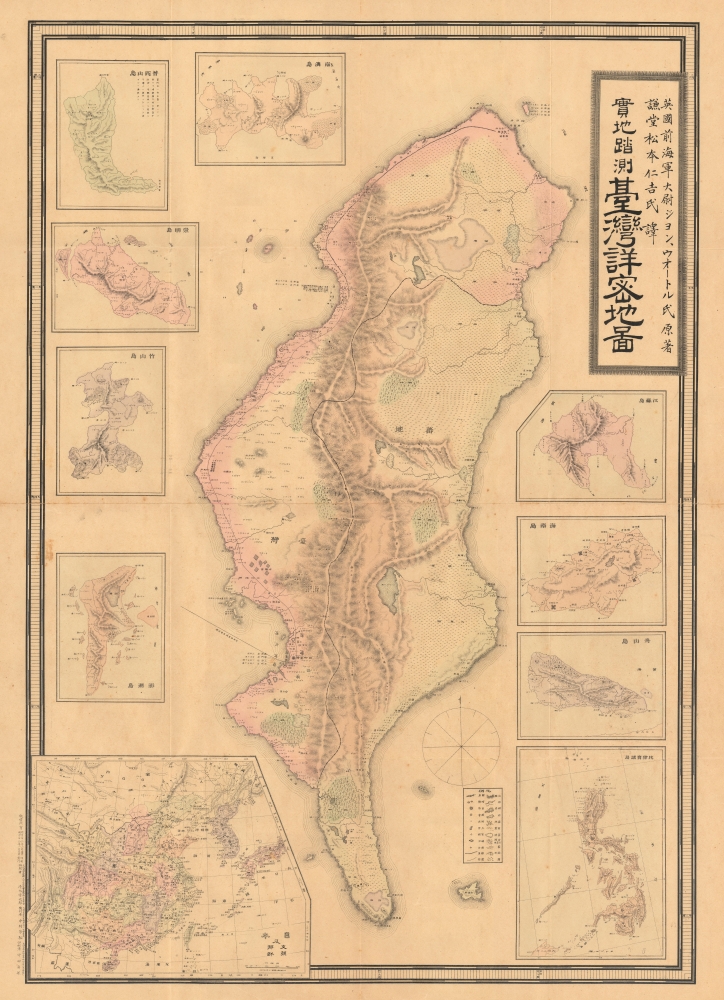
Detailed Map of Taiwan Field Survey. / 實地踏測台灣詳密地圖
1895 (dated) 40.5 x 29 in (102.87 x 73.66 cm) 1 : 438000
1895 (dated) 40.5 x 29 in (102.87 x 73.66 cm) 1 : 438000
Description
This 1895 Nakamura Yoshimatsu map of Taiwan is one of the most unsung but influential examples of persuasive cartography ever published. The large-scale map of Taiwan appeared at the end of the First Sino-Japanese War (August 1, 1894 - April 17, 1895), just prior to the Treaty of Shimonoseki (April 17, 1895) and the Japanese invasion of Taiwan (May 29, 1895 - October 21, 1895). The map, attributed to a likely fictional British naval officer named John Waters, employs creative cartography to reshape Taiwan, while retaining the overall area, effectivley reducing the size of Qing controlled Formosa and increasing the size of the ungoverned 'savage zones' - a ploy that played into the Japanese position that the Qing did not truly possess the island. It was likely presented at the Shimonoseki negotiations, where the Japanese were able to take advantage of Qing China's infamous lack of cartographic knowledge about Formosa to formally seize the island.
There are several hints that this is not the case. First, Formosa is mapped correctly in the inset regional map in the lower left. Moreover, we are aware that the Japanese had accurate European maps of Taiwan collected for the Japanese Punitive Expedition of 1874. Second, the enlarged bays correspond to the largest and most important harbors in Taiwan at the time, Tainan and Hsinchu. The mismapping of these harbors dually reduced the apparent size of western Formosa, which was predominantly Qing Chinese, and correspondingly increased the size of the 'uncivilized' tribal lands of eastern Formosa - long a thorn in the side of Qing provincial administrators.
While this map was printed near the end of the First Sino-Japanese War, in February 1895, the powers had yet to sit down at the Shimonoseki negotiating tables, which did not occur until March 20, 1895. Nonetheless, Japanese interest in Formosa was well-established. Near the end of the Sino-Japanese War, the U.S. Minister in Beijing, Colonel Charles Denby, wrote, 'China ceding Taiwan to Japan was sure to be a condition of any peace settlement.'
During the negotiations at Shimonoseki, the Qing were initially unwilling to surrender Taiwan, recognizing its strategic military and commercial potential. Nonetheless, they ultimately relented. One imagines the Japanese negotiator pulling out this map, proudly proclaiming that it was a 'new' survey made by a 'British Royal Navy' officer and so sure to be accurate. Then, saying, 'Look how small the area of western Formosa under your control is! Look at these dangerous tribal lands in the mountains, who are always at war with you! We are doing you a favor…'
A Closer Look
This map was likely a diplomatic and propaganda ploy prepared in anticipation of the Shimonoseki treaty negotiations, which included an Imperial Japanese demand for the Qing cession of Formosa/Taiwan. The map illustrates Taiwan/Formosa with a striking malformed shoreline and inaccurate interior, expanding Tainan and Hsinchu harbors into vast bites, adding corresponding projections to eastern Formosa, and shifting the Central Mountains westwards. Shimizu further misses the geography of the Tamsui River and Taipei entirely, instead placing Tamsui on the island's northwest coast, where Hsinchu is actually located. A note near the inaccurately placed Tamsui refers to the Sino-French War (1884 - 1885); fighting did indeed take place near Tamsui, but a map of the conflict should have pointed Shimizu to the harbor's correct location. The capital of Taiwan (台灣府城) is noted in large letters at present-day Tainan, while smaller text (台灣府) more correctly indicates its location at today's Taichung, though even this was inaccurate as the capital had moved on to Taipei from Taichung in 1887. The deviations from established Formosa cartography, much of which was available to the Japanese, indicate an insidious intent - a diplomatic deception intended to diminish the territorial significance of Qing-administered Formosa, then limited to the coastal lowlands west of the Central Mountain Range, while at the same time exaggerating the eastern ungoverned tribal regions and retaining the island's overall area.The Inaccuracies: Mistakes or Deceitful Propaganda?
The map is rife with errors and inaccuracies that are difficult to explain, especially when the inset regional map in the lower left presents a far more accurate picture of Taiwan/Formosa. We are also aware of c. 1874 manuscript maps collected by the Japanese that are far more accurate and detailed. Curiously, the errors are most pronounced on the historically well-mapped western or 'Chinese' side of the island. As previously noted, the cartographer exaggerates the size of Tainan and Hsinchu harbors, transforming them into vast bights, while at the same time mapping corresponding land projections on the eastern side of the island. Given that the western bays are mirrored by eastern projections, one might be tempted to assign this to a series of inaccurate measurements.There are several hints that this is not the case. First, Formosa is mapped correctly in the inset regional map in the lower left. Moreover, we are aware that the Japanese had accurate European maps of Taiwan collected for the Japanese Punitive Expedition of 1874. Second, the enlarged bays correspond to the largest and most important harbors in Taiwan at the time, Tainan and Hsinchu. The mismapping of these harbors dually reduced the apparent size of western Formosa, which was predominantly Qing Chinese, and correspondingly increased the size of the 'uncivilized' tribal lands of eastern Formosa - long a thorn in the side of Qing provincial administrators.
While this map was printed near the end of the First Sino-Japanese War, in February 1895, the powers had yet to sit down at the Shimonoseki negotiating tables, which did not occur until March 20, 1895. Nonetheless, Japanese interest in Formosa was well-established. Near the end of the Sino-Japanese War, the U.S. Minister in Beijing, Colonel Charles Denby, wrote, 'China ceding Taiwan to Japan was sure to be a condition of any peace settlement.'
During the negotiations at Shimonoseki, the Qing were initially unwilling to surrender Taiwan, recognizing its strategic military and commercial potential. Nonetheless, they ultimately relented. One imagines the Japanese negotiator pulling out this map, proudly proclaiming that it was a 'new' survey made by a 'British Royal Navy' officer and so sure to be accurate. Then, saying, 'Look how small the area of western Formosa under your control is! Look at these dangerous tribal lands in the mountains, who are always at war with you! We are doing you a favor…'
Japanese Occupation of Taiwan
Japan occupied Taiwan from 1895 to 1945. Japanese naval forces invaded Taiwan in May 1895, less than a month after the Treaty of Shimonoseki (April 17, 1895). The occupation of Taiwan fit into Imperial Japan's Nanshin-ron (南進論) or Southern Expansion Doctrine, which argued that Taiwan, Southeast Asia, and the Philippines were essential to Japan's economic and territorial growth. Katsura Taro (1747 - 1913), a Yamaguchi Samurai, wrote of Taiwan's significance, 'It is not only the most ideal location for expanding power to southern China, but also the islands of Southeast Asia.' Although there were some indigenous attempts at resistance and self-governance, including the founding of the 'Republic of Formosa,' Asia's first republic, the Japanese were quickly able to suppress Formosan nationalism. In less than 6 months, Japanese naval forces achieved, with the arguable exception of the tribal central highlands, full control of the island. Taiwan was Japan's first major extraterritorial holding, and Imperial Japan worked diligently to transform it into a showpiece 'model colony.' Japan lavished resources on the island's economy, including public works, industrial development, and cultural Japanization. After an initial period of unrest, the Japanese were generally effective in Taiwan, where they were, for the most part, approved of by the Taiwanese, who appreciated the advanced technology and economic growth. Of course, the darker side of Imperial Japanese investment in Taiwan was its planned essential role in supporting Japanese military aggression in the Asia-Pacific.The Mysterious Source: John Walter / Water
Text on the map claims the cartography is copied from work done by a former British Royal Navy officer named John Walter or Water (ジョン・ウォートル), who supposedly surveyed Taiwan in 1894. We have been unable to trace Walter/Water/Waters or any survey work completed by this individual. Certainly, the British Royal Navy was active in the waters around Formosa from 1817 and had successfully compiled a respectable map of the coast by 1867, but there is no record of 'Walter,' or any variant thereof, associated with any of the survey teams. We did identify a marine engineer by the name of 'John Walker' who was active in the Japan trade in 1894 when he was involved with a shipwreck of the Japanese-owned steamer Nagato Maru. Whoever 'Walter' was, he was either a terrible hydrographer or intentionally deceitful. Walter's map was translated into Japanese by Matsumoto Nikichi. It is likely that 'Walter' was a fiction created by the Japanese publisher Nakamura Yoshimatsu (中村芳松) to confer British legitimacy upon the map.The Inset Maps
From just under the title block, the insets are, clockwise,- 江蘇島 ('Jiangsu Island' - perhaps another cartographic myth that was seemingly meant to be located at the mouth of the Yangtze River)
- 海南島 (Hainan Island - also misshapen, though not as badly as Taiwan on the main map)
- 舟山島 (Zhoushan Island, oriented with east at top)
- 菲律賓群島 (Philippine Islands, north oriented)
- 澎湖島 (Penghu Island - supposedly, does not clearly resemble any of the Penghu Islands, and indicating a field for fishing sardines or herring 鰯魚場 off the east coast)
- 竹山島 (Zhushan Island - probably meant to represent three close islands of Upper, Middle, and Lower Zhushan 上竹山岛, 中竹山岛, 下竹山岛 off the coast of Ningbo).
- 崇明島 (Chongming Island)
- 普陀山島 (Putuoshan Island - identified as Putuoshan, but more closely resembles nearby Zhuijiajian Island, a strange error given the island's long connection with Japanese Buddhism; north oriented)
- 南澳島 (Nan'ao Island) - Small Island in Shantou County, directly west of Taiwan on China coast - oriented to the south.
Publication History and Census
This map was prepared (edited) by Shimizu Tsunetaro and printed by Nakata Sadanori (中田貞矩), seemingly an employee of the publisher, Nakamura Yoshimatsu (中村芳松). As mentioned above, it is supposedly based on a British map by John Walter or Waters, as translated by Matsumoto Nikichi. The map was published in Osaka, Japan, on February 1, 1895 (Meiji 28) and released shortly thereafter on February 5. The map had a small print run and a very short period, less than a month, of relevancy, making it quite rare. There were also smaller editions published, which are slightly more common. Of this wall map size, we are aware of examples at the National Diet Library, Waseda University, the National Archives of Japan, the National Museum of Taiwan History, and the Taiwan National Archives.CartographerS
Nakamura Yoshimatsu (中村芳松; fl. c. 1882 - 1906) was a major Japanese book and map publisher active in Osaka during the late 19th and early 20th centuries. The firm's output varied, but mostly consisted of maps, geographical texts, and works discussing or glorifying the military. More by this mapmaker...
Shimizu Tsunetaro (清水常太郎; fl. c. 1892 - 1897) was a Japanese cartographer active in the 1890s based in Kyoto and Osaka. Little else is known about his life and work. His maps coincided with Japan's imperial expansion, focusing on Taiwan, Korea, and China, though he also produced maps of Japanese cities such as Nagasaki and Saga. Learn More...
Matsumoto Nikichi (松本仁吉; fl. c. 1892 - 1897) was a Japanese geographer, translator, and educator based in Osaka. Little is known about his life, but Matsumoto was quite active during the 1890s, authoring several school textbooks and translating maps, including a very early Japanese map of Taiwan after the island was annexed in 1895. He also published a detailed geography of the islands of Taiwan the same year (臺灣島地誌撮要附錄), indicating he was something of a Taiwan expert just as Japan took control of the territory. The following year, he prepared the New Pocket Atlas (袖珍萬國地圖), based on John Bartholomew's Pocket Atlas of the World, which Matsumoto translated into Japanese and slightly modified. He also appears to have co-authored a four volume series of commentaries on Tang Dynasty poetry the same year, reflecting a broad range of interests and talents. Learn More...
Condition
Very good. Slight wear on old fold lines.
References
OCLC 675441082. National Taiwan History Museum 0000228540. Kyoto University Comprehensive Museum Collection. Keating, J. F., The Mapping of Taiwan: Desired Economies, Coveted Geographies, page 98. National Diet Library: YG913-2251. Hiroshima University Central Library: 033:180100013771.