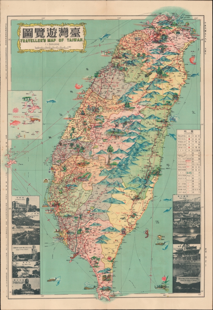
Title
台灣遊覽圖 / Traveller's Map of Taiwan.
1969 (dated)
30.5 x 20.75 in (77.47 x 52.705 cm)
1 : 500000
Description
A 1969 (Minguo 58) bilingual pictorial map of Taiwan, as vibrant as the island itself, edited by Ch'en I-jen, drawn by Chou I-li, and published by Nan-hua Publishing House in Taipei.
A Closer Look
The map covers the main island of Taiwan (Formosa) and nearby islands, functionally equivalent to the Republic of China since 1949. A tremendous amount of information on roads, railways, air routes, administrative boundaries, mountain foot paths, shipping routes, hot springs, beaches, lighthouses and more are noted in a bilingual legend at right. Some place names are transliterated into Latin letters, including the names of counties, which are color-shaded for easy distinction. Throughout, colorful illustrations depict local attractions, products, and landmarks.
An inset at left provides more detail on the Penghu Islands in the Taiwan Straits (though the heavily militarized Kinmen County, directly off the coast of mainland China, is not referenced or depicted). At bottom are black-and-white photographs of major government buildings, natural sites, and cultural landmarks with both Chinese and English names.
The map gives a clear sense of the concentration of cities and infrastructure around Taipei and down the island's west coast. Little direct mention is made of the island's indigenous inhabitants, though some do appear in illustrations in the island's mountainous interior and on the east coast - the Kuomintang-led government at the time pursued assimilationist policies and suppression of indigenous languages and culture. The government, paranoid about Communist spies and a citizenry that had lived under Japanese rule for fifty years, also maintained martial law, reflected in the map's official registration information (i.e. approval by censors) at top-left.
The inclusion of some English on the map is notable. Several thousand American missionaries, advisors, academics, aid workers, and troops lived in Taiwan at this time. Many more troops serving in Vietnam and elsewhere in Asia would visit the island when on 'R and R' (rest and recuperation), and they were likely the most numerous among the map's intended audience. The 1960s also saw efforts by the Republic of China government to attract foreign investors, who began visiting Taiwan in much larger numbers as a result.Publication History and Census
This map was edited by Ch'en I-jen (陳逸人), illustrated by Chou I-li (周宜立) and published by the Nan-hua Publishing House in 1969 (Minguo 58). Maps with this title published by Nan-hua and edited by Chen date from the early 1960s into the 1990s, but the older editions especially are difficult to find today. There are no example of the present edition in institutional collections, with the nearest matches being a 1967 (Minguo 56) example held by the National Museum of Taiwan History, a 1968 (Minguo 57) example held by the Chinese University of Hong Kong as part of the Li Junyi (Lee Chun-Yi) Papers (李君毅書信文件), and a 1972 (Minguo 61) edition held by the National Central Library
CartographerS
Ch'en I-jen (陳逸人; fl. c. 1964 - 1987) was a cartographer based in Taiwan who primarily made maps of Taiwan's cities and counties, though he occasionally forayed into other subjects, such as such as Malaysia. His major achievement was collection of maps of counties in Taiwan (台灣省各縣地圖), published by Nan-hua ch‘u-pan-she (南華出版社) in several editions in the 1960s and 1970s. More by this mapmaker...
Nan-hua ch‘u-pan-she (南華出版社; fl. c. 1937 - 1993) was a publisher of maps and books originally based in Shanghai that relocated to Taipei in the late 1940s. Its maps mostly focused on Taiwan, while its books covered a wide range of topics, primarily in the fields of geography and politics. The company was operated and likely named after Wei Nan-hua (魏南華). Learn More...
Condition
Good. Wear along original fold lines. Verso repairs to fold separations and at fold intersections. Slight loss at fold intersections. Closed tear extending 1 inch into printed area from top margin professionally repaired on verso. Light foxing.
References
National Museum of Taiwan History Registration No. 2004.028.4415. Chinese University of Hong Kong HK CVU 0112/PER/LiJY. OCLC 856774913 (1972 ed.).