
This item below is out of stock, but another example (left) is available. To view the available item, click "Details."
Details
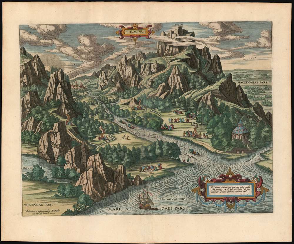
1590 / 1603 Ortelius View of The Paradise of Tempe at the foot of Mount Olympus
$750.00
1603 Ortelius View of The Paradise of Tempe at the foot of Mount Olympus
Tempe-ortelius-1603$750.00

Title
Tempe.
1603 (dated) 14 x 18.75 in (35.56 x 47.625 cm)
1603 (dated) 14 x 18.75 in (35.56 x 47.625 cm)
Description
This is a lush example of Ortelius' 1590 engraving of the Vale of Tempe in Greece, overshadowed by Mount Olympus. The narrow valley of Tempe, or Témbi as it is now known, is a river valley situated on the coast of the Aegean Sea, and pierces the mountainous border between ancient Macedonia to the north and Thessaly to the south. The view centers on the river Pineiós (Peneus on the view) and its tributaries, and is oriented to the west. To the south is depicted mount Ossa; to the north, mighty mount Olympus towers over the valley. The mountains and their forbidding cliffs frame the beautifully wooded river Pineiós, emptying into the Aegean. In legend, this rift was formed by an earthquake caused by a blow from Poseidon's trident. (Geologists call it a fracture ravine, caused by the action of the river and its tributaries.) The verdant beauty of the valley - and it is still so - led the ancient Greeks to dedicate the valley to the cult of Apollo. (Ortelius has also included a temple to Jove, at the mouth of the river.) Along the banks, in the woods and in meadows are shown groups of people offering burned sacrifice, dancing, playing music, and plunging naked into the stream. Ortelius describes the scene as a place 'where people dwell, meet in companies, and having done divine service and ceremonies in due form and manner, they banquet and make merry.'
Another Way to Look at a Valley
What is not depicted in the view is that this beautiful valley represented - as the best access between the coast of Macedonian Greece to the plains of Thessaly - a natural and traditional invasion route. Byzantine Greeks called this lovely place 'The Wolf's Mouth.' Ortelius, in choosing to emphasize the classical and mythological aspects of the place, declines to show the ruined castles and fortifications dating from the Roman era to the Middle Ages that were to be found here even during the second World War.By the Hand of the Master
Ortelius's depiction, drawn primarily from classical historical and literary sources such as Ovid, Varro, Herodotus and Pliny, is remarkable in being one of the engravings entirely his own work. While Ortelius was notable for his assiduous presentation of the best available contemporary geographical sources, he relied on his own composition when it came to the maps and views pertaining to ancient history, biblical history and classical myth.Publication History and Census
This engraving was first printed in 1590 as a separate issue, and then included both in Ortelius' Parergon and in his Theatrum Orbis Terrarum. There are two known states of this piece: In 1601, the plate was reworked to improve both the engraving of the sky and the trees. This second state example was included in the 1603 Theatrum which its publisher, Vrients, called 'Editio Ultimo' (As it happened, four further editions would be published.) About twenty examples of the map appear in OCLC as a separate. Ortelius' atlas is well represented in institutional collections.Cartographer
Abraham Ortelius (April 14, 1527 - June 28, 1598) also known as Ortels, was a cartographer, geographer, and cosmographer of Brabant, active in Antwerp. He was the creator of the first modern atlas, Theatrum Orbis Terrarum and is a seminal figure in the history of cartography. Along with Gerard Mercator and Gemma Frisius, he was a founder of the Netherlandish school of cartography. His connections with Spain - culminating in his 1575 appointment as Royal Cartographer to King Phillip II of Spain - gave him unmatched access to Spanish geographical knowledge during a crucial period of the Age of Discovery. Ortelius was born in 1527 in Antwerp. In 1547 he entered the Antwerp Guild of Saint Luke as an illuminator of maps. He began trading in books, prints, and maps, traveling regularly to the Frankfurt book and print fair, where in 1554 he met Mercator. He accompanied Mercator on journeys throughout France in 1560 and it was at this time, under Mercator's influence, that he appears to have chosen his career as a scientific geographer. His first published geographic work appeared in 1564, an eight-sheet cordiform world map. A handful of other maps preceded the 1570 publication of the first edition of the Theatrum Orbis Terrarum, which would prove to be his life work. Appearing with but 53 maps in its first edition, Ortelius' work expanded with new maps added regularly. By 1592, it had 134 maps. Many of Ortelius' maps remained the standard for nearly a century. He traveled extensively, but his genius was as a compiler, locating the best informed maps on which to base his own. His contacts throughout Europe and extending even (via the Portuguese) to the Far East were formidable. Moreover, many of his maps were based on his own scholarship, particularly his historical works. His theories of geography were particularly ahead of his time with respect to the notion of continental drift, the possibility of which he mused on as early as 1596, and which would be proven correct centuries later.
In a sense his greatest achievement was his successful navigation of the religious and political violence endemic to his city throughout his adult life: The Dutch Revolt, or Eighty Years' War (1568 - 1648), fully embroiled Antwerp. Although outwardly and officially recognized as Catholic (Arias Montanus vouched for Ortelius' Catholic orthodoxy prior to his appointment as Royal Geographer), Ortelius was able to separate himself from the religious furor which characterized the war in the low countries. Ortelius showed a glimpse of himself in a letter to a friend, regarding humanist Justus Lipsius: 'I do not know whether he is an adherent of the Pope or a Calvinist, but if he has ears to hear, he will neither be one nor the other, for sins are committed on both sides'. Ortelius' own explorations of Biblical history in his maps, and the Christogram contained in his own motto, suggest him to be a religious man, but his abjuration of political religious authorities mark him as an individualist. His tombstone at St Michael's Præmonstratensian Abbey in Antwerp bears the inscription, Quietis cultor sine lite, uxore, prole. ('served quietly, without accusation, wife, and offspring.') More by this mapmaker...
Source
Ortelius, A., Theatrum Orbis Terrarum, (Antwerp) 1603.
Abraham Ortelius' magnum opus, Theatrum Orbis Terrarum, was the world's first regularly produced atlas, which 'set the standards for later atlases . . . It was the first undertaking of its kind to reduce the best available maps to an uniform format.' (Koeman) A modestly-sized work of fifty-three maps in its first edition of May 1570, it was an immediate success: there were three further editions that year, and the work remained in print for a total of 32 editions, the last of which was 1641, well after its author's 1598 death. Ortelius added to his atlas constantly, and by 1595 the Theatrum contained 147 maps. Ortelius is renowned generally as an editor, and indeed much of the Theatrum is compiled from a variety of sources: in such cases, Ortelius was scrupulous in naming his sources. But Ortelius was also a mapmaker in his own right: many of his maps are a distillation of various sources into his own work, and there were many maps - particularly in his atlas of Biblical and ancient history Parergon - which were entirely Ortelius' work. In his role as an editor, Ortelius followed in the footsteps of Munster, whose Cosmographia was, until Ortelius, the best window on the world for the curious European reader. In terms of the artistry of his maps, Ortelius oversaw the first great flourishing of copperplate engraving in the service of cartography to occur in Northern Europe. Ortelius' work provided the model for the atlases of Mercator, Hondius, Blaeu and all their progeny in the 17th century - many of whom were to produce faithful editions of Ortelius' maps in their own productions.
Condition
Excellent condition. Fine hand color; marginal mend at left not affecting image, else fine.
References
OCLC 837691033. van den Broecke 231.2.