This item has been sold, but you can get on the Waitlist to be notified if another example becomes available, or purchase a digital scan.
1685 Bormeester Map of the World
TerrarumOrbis-bormeester-1685$4,000.00

Title
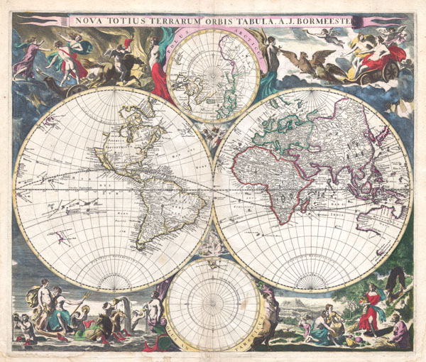
Nova Totius Terrarum Orbis Tabula. A. J. Bormeester.
1685 (undated) 20 x 22 in (50.8 x 55.88 cm)
1685 (undated) 20 x 22 in (50.8 x 55.88 cm)
Description
An extremely scarce 1684 double hemisphere world by Dutch map publisher Joachim Bormeester. Depicts the world on hemisphere projection with polar projections to the top and bottom of the main map. Surrounded by allegorical images and border decorations with a classical theme. Heavily based upon, but much rarer than, the Visscher world map of 1658, with similar cartography and Nicholas Berchem's border designs.
We begin our survey of this map in North America. California is depicted as an island. The American northwest is largely blank and unexplored though the land of Anian does appear in the extreme northwest. Anian, first mentioned in the journals of Marco Polo, is the semi-mythical land one arrives at having transited the Northwest Passage. Heading east, the Great Lakes are shown as a single massive inland lake with no western boundary. Southward finds us in South America where both the Amazon and the Rio de la Plata meet in a great lake. Another mysterious and vast inland lake appears in what is roughly modern day Guiana and Venezuela. The Pacific offers a few interesting destination. New Zealand appears only as a line of coast with no northern southern or eastern borders. Several islands dot the South Pacific, but any connection with true geography here seems entirely conjectural. In the Eastern Hemisphere, Africa is displayed according to the 17th century conceptions of the interior. The source of the Nile depicted here conforms to the Ptolemaic double lake theory prevalent at the time. The Niger River system passes through several enormous lakes which are entirely conjectural. Other interior detail in the African continent is extensive but wholly inaccurate. In Asia the Great Wall of China is displayed. Korea is shown as an island. Kamtschaka is not present though Siberia does extend eastward slightly into the Western Hemisphere. Further south, Australia is recognizable if only sketchily mapped. Antarctica remains undiscovered. In the northern polar projection no suggestion is made of Northwest Passage.
Surrounded by elaborate classical motif border images originally drawn by Berchem for Visscher's map. These include the Rape of Persephone, Zeus in his chariot, Demeter offering the gifts of the Earth, and Poseidon riding his chariot out of the sea.
An extremely scarce find. This map has only appeared twice in the last 30 years and appears in the catalogs of almost no major collections.
CartographerS
Joachim Bormeester (16?? - 1702) was an engraver, printer and publisher working in Amsterdam during the late 1600s. Bormeester appears to have worked on occasion with Danckerts and other Dutch publishers of the period. His cartographic works are extremely scarce and rarely appear on the market. More by this mapmaker...
Claes Jansz Visscher (1587 - 1652) established the Visscher family publishing firm, which were prominent Dutch map publishers for nearly a century. The Visscher cartographic story beings with Claes Jansz Visscher who established the firm in Amsterdam near the offices of Pieter van den Keer and Jadocus Hondius. Many hypothesize that Visscher may have been one of Hondius's pupils and, under examination, this seems logical. The first Visscher maps appear around 1620 and include numerous individual maps as well as an atlas compiled of maps by various cartographers including Visscher himself. Upon the death of Claes, the firm fell into the hands of his son Nicholas Visscher I (1618 - 1679), who in 1677 received a privilege to publish from the States of Holland and West Friesland. The firm would in turn be passed on to his son, Nicholas Visscher II (1649 - 1702). Visscher II applied for his own privilege, receiving it in 1682. Most of the maps bearing the Visscher imprint were produced by these two men. Many Visscher maps also bear the imprint Piscator (a Latinized version of Visscher) and often feature the image of an elderly fisherman - an allusion to the family name. Upon the death of Nicholas Visscher II, the business was carried on by the widowed Elizabeth Verseyl Visscher (16?? - 1726). After her death, the firm and all of its plates was liquidated to Peter Schenk. Learn More...
Nicolaes Pieterszoon Berchem (October 1, 1620 – February 18, 1683) was an important Dutch painter working in the middle part of the 17th century. Bercham was born in Haarlem and studied under both Jan va Goyen and Cornelis van Poelenburgh. He is credited with over 800 paintings and is mostly known for his bucolic Italian landscapes. Berchem's partnership with Jan Visscher in the production of Visscher's world atlas was a seminal moment in cartography. Shirley describes Berchem's engraving work, particularly focused on the elaborate borders of Visscher's maps, as "the master forerunner for a number of highly decorative Dutch maps". The work of Berchem and Visscher inspired Dutch cartographers and map publishers for the next 60 years. Learn More...
Source
Independent Issue.
Condition
Very good condition. Original centerfold. Original platemark visible. A couple of minor closed tears to border, none of which extend into the printed area. Minor printing crease about 1 inch left of centerfold. Original hand color.
References
Shirley, Rodney W., The Mapping of the World: Early Printed World Maps 1472-1700, #527.