This item has been sold, but you can get on the Waitlist to be notified if another example becomes available.
1968 'Engineering Branch' Manuscript Map of Vietnam / Tet Offensive
TetOffensiveVietnam-pjv-1968$750.00

Title
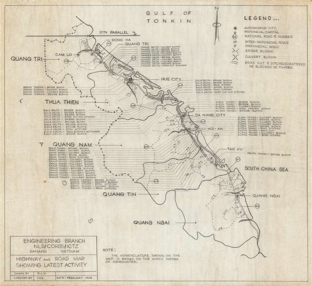
Highway and Road Map Showing Latest Activity.
1968 (dated) 17.25 x 19 in (43.815 x 48.26 cm) 1 : 843000
1968 (dated) 17.25 x 19 in (43.815 x 48.26 cm) 1 : 843000
Description
History as it was happening, this is a February 1968 manuscript map of northern Vietnam highlighting the damage done to Vietnam Highway 1 at the height of Tet Offensive. The map was drawn by P. J. V. of the Engineering Branch of CORDS, a civilian partnership with the U.S. military in Vietnam. By blowing bridges along the strategically critical highway, the North Vietnamese effectively disrupted American supply lines. Transportation along Highway 1 was not completely restored until March 1968. Sixty-five locations along the highway highlight blown bridges and culverts as well as 'cut and ditched' zones. Each section of highway is termed phonetically, ie. 'Alpha Tango', 'Yankee Delta', and 'Bravo Tango' 'based on the MACV system of coordinates'. Da Nang, Hue, Quang Ngai, and Dong Ha are labeled, along with several smaller towns and villages.
The New Life Development Division of the Office of Civil Operations and Rural Development Support
The New Life Development Division was part of the Office of Civil Operations and Rural Development Support (CORDS), which had offices in every military region in Vietnam. Each CORDS office coordinated pacification and rural development. The New Life Development Division, abbreviated NLD, was a CORDS subdivision responsible for coordinating advisory efforts including education, logistics, agriculture, and public works. NLD was deactivated in mid-1969 and its duties transferred to the newly-created Government Development Division and the Economic Development Division. The present map was created by the office in Military Division 1, also known as the I Corps Tactical Zone.The Tet Offensive
The Tet Offensive (January 30, 1968 - September 23, 1968), one of the largest North Vietnamese / Vietcong offensives of the Vietnam War, began on January 30, 1968. The Offensive comprised of coordinated surprise attacks targeting both military and civilians. All told, the North Vietnamese struck more than 100 towns and cities, including Saigon, the capital of South Vietnam, and 36 of 44 provincial capitals. U.S. forces were caught unprepared and by the second week of February had suffered over 9000 casualties.The Vietnam War
The Vietnam War, known in Vietnam as the Resistance War Against America or simply the American War, raged between November 1, 1955, and April 30, 1975, when Saigon fell to the North Vietnamese. A complicated conflict with an even more complicated history and legacy, the Vietnam War pitted the North Vietnamese, led by Ho Chi Minh, against the South Vietnamese. The South Vietnamese were supported by the United States, while the Soviet Union and China supported the North Vietnamese. American anti-communist dogma and fear that 'if one country fell to Communism, then more would fall' drove participation in the far-off civil war. As the conflict grew, American involvement became increasingly overt. Finally, in 1964, American ground troops were sent into combat. When this map was drawn, in 1968, U.S. troop strength in Vietnam reached its maximum at 549,500 soldiers. The same year saw the Tet Offensive, the most successful North Vietnamese campaign against American forces, and a waning of American home front support. U.S. forces withdrew in January 1973, and Saigon fell to the North Vietnamese on April 30, 1975.Publication History and Census
This map was drawn by P. J. V. and checked by D.R.Z of the Engineering Branch of the New Life Development Division of the Office of Civil Operations and Rural Development Support in the I Corps Tactical Zone in February 1968. This map is manuscript and therefore unique. There is no suggestion that it was ever published, but the production style, on a thin waxed paper, suggest it may have been internally reproduced in small quantities - perhaps 10 - 20 at most. The map's content was time-sensitive in nature, and the piece is intended for immediate wartime use, suggesting extreme ephemerality.Condition
Very good. Hand drawn in pencil on wax paper. Exhibits some light soiling.