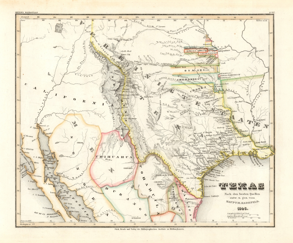
1846 Radefeld Map of the Republic of Texas
Texas-radefeld-1846$1,500.00

Title
Texas nach den besten Quellen entw. u. gez. vom Hauptm. Radefeld.
1846 (dated) 12 x 14 in (30.48 x 35.56 cm) 1 : 7509000
1846 (dated) 12 x 14 in (30.48 x 35.56 cm) 1 : 7509000
Description
An important 1846 first edition of Joseph Meyer and Carl Christian Franz Radefeld's map of the Republic of Texas in its final days, just before joining the United States. This map was issued shortly before the outbreak of the Mexican-American War (1846 - 1848) and, as such, constitutes the fullest expression of independent Texas, including a unique configuration incorporating New Orleans. Texas was of great interest to Meyer's primarily German audience, to whom immigration was actively promoted through a number of Texas-booster societies, some of which were legitimate and others which were outright cons.
A Closer Look
Coverage embraces the Republic of Texas with its fullest boundaries and then some: mysteriously incorporating New Orleans, extending west to include Santa Fe and Albuquerque, and reaching amorphously north well into modern-day Wyoming. The map includes a detailed accounting of American Indian reserves established in the wake of forced relocations of the 1830s - the Trail of Tears. Roads, settlements, and topography, as well as a confusing array of boundaries and explorer's tracks are noted.Texas including New Orleans?
The map is somewhat based on the seminal 1844 Emory map of Texas, the definitive US Government mapping of Texas during its period as a Republic. This map, nonetheless, features a unique configuration incorporating New Orleans. The reasoning behind this boundary is unclear. We see no evidence that Texas ever laid claim to New Orleans; however, it is undisputed that ties between the Republic and New Orleans ran deep and ranged from financing to popular support and significant military support, including disastrously at the Alamo.The Republic of Texas
The Republic of Texas was a short-lived nation established in March 1836 when it seceded from Mexico. Following the independence of Mexico from Spain, the American Stephen Fuller Austin led a group of 300 Empresarios to settle Texas, near Austin, where they received a grant from the Mexican government. As more Americans moved to Texas, resentment and strife began to build between the American settlers and Mexican authorities. This and other factors ultimately led to the Texan Revolution in 1835 and the declaration of Texan independence in 1836. Texas remained an independent republic until it joined the United States ten years later in 1846.Texas Borders
The borders of the Republic of Texas were in dispute from the earliest days of the Texan Revolution. The Republic-claimed borders followed the Treaties of Velasco between the newly created Texas Republic and Mexican leader, Antonio López de Santa Anna. The treaties established an eastern boundary following the 1819 Adams-Onís Treaty between the United States and Spain, which established the Sabine River as the eastern boundary of Spanish Texas and the western boundary of the Missouri Territory. The Republic's southern and western boundary with Mexico was more nuanced. Texas claimed the Rio Grande del Norte as its western and southernmost border, while Mexico argued for a boundary much further east at the Nueces River. When Texas was annexed into the United States, the agreement followed the Republic-claimed boundary, thus absorbing Mexican-claimed territory as far west as Santa Fe. This escalated already existing tensions between the United States, the former Republic of Texas, and Mexico, ultimately triggering the Mexican-American War (1846 - 1848). The present map is the only map we are aware of to include New Orleans within the boundaries of Texas.Publication History and Census
This is one of several unique maps prepared by Carl Christian Franz Radefeld for the 1846 edition of Meyer's Grosser Hand-Atlas. This example is the first edition. The map was updated regularly in multiple editions, reflecting new discoveries and political changes through 1860. The first edition is extremely rare, as we note no history of the map on the market and few examples in institutional collections - often difficult to assess as many examples bear the same title and date despite significant updates.CartographerS
Joseph Meyer (May 9, 1796 - June 27, 1856) was a German industrialist, merchant, and publisher, active in Germany in the early to mid 19th century. He is best known for publishing the encyclopedia Meyers Conversation-Lexicon. Born in Gotha, Germany, Meyer was educated as a merchant in Frankfurt am Main. He moved to London in 1816, but returned to Germany in 1820 after his stock speculations and business adventures fell through. Once back in Germany, he began by investing in the textile trade (1820 - 24). Meyer began creating business plans concerning how to start railways soon after the first steam-hauled railway began operation in December 1835. He founded the Deutsche Eisenbahnschienen-Compangie auf Actien (German Railway Rail joint stock company) in 1845. Meyer also found great success as a publisher, utilizing the system of serial subscriptions to publications, a new idea for the time. He founded a company, Bibliographisches Institut in Gotha in 1825, which published several versions of the Bible, works of classical literature, atlases, the world in pictures on steel engravings, and an encyclopedia. He moved the Institut from Gotha to Hildburghausen in 1828. He published several atlases, including Meyer's Groẞer Hand-Atlas (1843 - 1860). In 1848, he supported the Springtime of the Peoples Revolutions that took place throughout Germany and much of Europe. When the revolutions failed in 1849, Meyer was briefly imprisoned for his support of revolutionary activities. The revolutions also began to take a toll on Meyer's business interests, and when he died, in 1856, the Bibliographisches Institut was struggling financially. His son, Herrmann Julius Meyer, took over the firm, spearheading a rapid recovery. This, and other businesses prospered under Herrmann Julius (April 4, 1826 - March 12, 1909) and when he died in 1909, he led the richest family in Saxony, with more total wealth than the King of Saxony More by this mapmaker...
Carl Christian Franz Radefeld (1788 - 1874) was a German lawyer and cartographer. Radefeld was born in Jena, Germany, where he studied law and theology and began working as a lawyer in 1811. He became interested in cartography in the 1840s when he became involved with map and atlas publisher Joseph Meyer (1796 - 1856). From 1846, he contributed maps to Meyer's Groẞer Hand-Atlas (1843 - 1860). Learn More...
Source
Meyer, J., Grosser Hand-Atlas uber alle Theile der Erde, (Hildburghausen: Bibliographischen Instituts) 1846.
Meyer's Grosser Hand-Atlas is Meyer’s most ambitious work, a true tour de force, featuring some 170 maps at its peak. These include 50 maps of the Americas. Among these, 33 are derived from the Tanner/Mitchell Universal Atlas, encompassing various U.S. States and Territories, Canada, and South America, with dates ranging from 1844 to 1854, predominantly from 1844 or 1845. Many maps in this atlas cite Philadelphia as their place of publication, along with other cities, suggesting a potential arrangement with Tanner and/or Mitchell for copying the maps. The U.S. maps dated 1844-46 derive from a late 1830s edition of Tanner’s Universal Atlas. U.S. maps dating from 1850-54 are based on 1850-54 Mitchell and Thomas Cowperthwait issues of the Universal Atlas. Exceptions are new maps of Texas, Iowa, and Wisconsin, which are unique to Meyer's atlas and feature content not found elsewhere. These maps appeared in editions of the atlas from 1846 to 1860, with changes reflecting new discovery and evolving political boundaries. Espenhorst also identifies a separate atlas published in 1860 featuring only these U.S. maps, titled Grosse und vollstandiger Auswanderungs-Atlas fur Nordamerika.
Condition
Very good. Slight edge toning.
References
Rumsey, 4807.165.