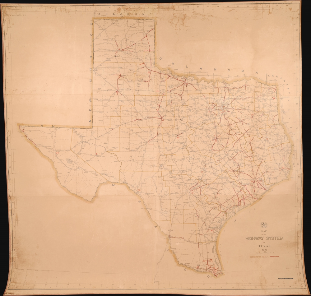
1932 Stene Wall Map of the Texas Highway System
TexasHighways-stene-1932$4,500.00


Title
Map of the Highway System o Texas 1932.
1932 (dated) 70 x 70 in (177.8 x 177.8 cm) 1 : 750000
1932 (dated) 70 x 70 in (177.8 x 177.8 cm) 1 : 750000
Description
This is a massive 1932 wall map of the Texas Highway System drafted by Robert Martin Stene - featuring manuscript updates suggesting that the map was issued for internal use only. It captures a critical early phase in the development of the highway system as it transitioned old dirt and macadamized roads to concrete. It is the largest planning phase highway map of Texas known to survive.
A Closer Look
This impressive map covers all of Texas. The state is divided into counties, themselves grouped into larger districts - presumably for the purpose of Highway Management. Red manuscript highlights the extent of concrete roads, most of which appear in the more populated parts of eastern Texas.Highways of Texas
Given Texas's enormous size and general lack of navigable rivers, transportation infrastructure issues plagued the state from its earliest days. Even railroads, which linked major cities, were limited by the enormous cost of developing long-distance trackage over largely empty land. The rise of automotive technology in the early 20th century offered a solution. The Texas Highway Department was established in 1917 to provide a centralized authority to oversee road development and maintenance. Initially, funding was scarce, and many roads were little more than dirt tracks, prone to becoming impassable in bad weather. However, with the Federal Highway Act of 1921, Texas began receiving federal funds, accelerating the construction and improvement of its highways. Texas was early in adopting new engineering techniques and materials, like concrete, that gradually replaced the dirt tracks of the past, with modern highways - as illustrated here.Publication History and Census
This map was compiled by Robert Martin Stene for the Texas Highway Department. We are aware of other official highway maps of Texas as early as 1922, however, we have come across no earlier map comparable in terms of scale. A note in the lower right states that this map was updated to October 31, 1932, so there is presumably an earlier issue, but we see no record of such surviving in any collection. As a side, the first publicly distributed official map of Texas highways, also drafted by Stene for the Texas Highway Department, was published in 1936 (HighwaySystem-stene-1936).Cartographer
Robert Martin Stene (May 23, 1872 - August 10, 1954) was an American cartographer and photographer. Born on a farm outside Norway Lake, Minnesota, his first job was as a station agent for the Great Northern Railway in Norway Lake. Then, in Fargo, North Dakota, he worked for the Hanson Studio, where he demonstrated a gift for operating a telegraph. This earned him a job as a telegraph operator. He moved to Texas for his health sometime before 1900 and settled in Austin where he worked as a photographer in Journey's Studio. Stene then worked as an advertising agent and telegraph operator for the Santa Fe railroad in Dallas and Galveston for several years before moving to San Francisco to study mapping. From there he joined mining engineers in Arizona and California as a map draftsman. Then, Stene started working as a hydraulic and mining engineer in Arizona, where he surveyed rivers and canyons for dam sites. He also founded a mining company to mine copper in Arizona. At some point during his time in Arizona, Stene organized the Williams River Corporation with the goal of building a dam and generating electricity. Unfortunately for Stene, after he had done the work to find financiers and supporters to build the dam, the project became public, and a different company was formed that took over the project. Stene was out and lost everything. At this point, around 1927, he moved back to Texas and joined the Texas Highway Department as a cartographer. He retired from the Highway Department in 1950. More by this mapmaker...
Condition
Very good. Laid down on pH neutral linen. Some discoloration and toning.