1800 George Burn / Laurie and Whittle Nautical Chart of the Thames River Entrance, England
ThamesEntrance-lauriewhittle-1800-2$650.00

Title
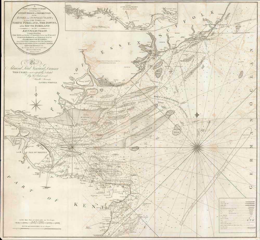
A New and Correct Chart extending from London Bridge to Orford Ness on the Essex and Suffolk coast and from the Nore to the North Foreland, the Downs, and South Foreland on the Kentish coast : comprehending the Swin and King's Channel, with the Wallet, Harwich Harbour, and Horsley Bay, to Aldborough Knapes, also the Five Fathom and South Channels, with the Oaze Deeps, Nubs and Queen's Channel, Kentish Knock etc., etc. By George Burn and several other masters and pilots in the Royal Navy.
1800 (dated) 35.5 x 39 in (90.17 x 99.06 cm) 1 : 5500000
1800 (dated) 35.5 x 39 in (90.17 x 99.06 cm) 1 : 5500000
Description
An impressive 1800 George Burn and Laurie and Whittle large format blueback nautical map of the entrance to the Thames River, England.
The map is dedicated to Lord Viscount Adam Duncan (1731 - 1804). Duncan was a British admiral famous for defeating the Dutch fleet off Camperton on October 11 of 1797. Duncan was awarded the Large Naval Gold Medal and an annual pension of £3,000, to himself and the next two heirs to his title - this was the biggest pension ever awarded by the British government. Additionally, he was given the freedom of several cities, including Dundee and London. Laurie and Whittle, no doubt sensing a potential patron with influence at the Hydrographic Office, chose this apt map to court his attention.
A Closer Look
The map covers parts of Kent, Essex, and Suffolk. It details the Entrance to the Thames River with its many shoals and coastal communities. A small inset map at the top of the chart continues the map westward from Canvey Island to London, with depth soundings and river towns noted. Throughout there are thousands of depth soundings in fathoms.The map is dedicated to Lord Viscount Adam Duncan (1731 - 1804). Duncan was a British admiral famous for defeating the Dutch fleet off Camperton on October 11 of 1797. Duncan was awarded the Large Naval Gold Medal and an annual pension of £3,000, to himself and the next two heirs to his title - this was the biggest pension ever awarded by the British government. Additionally, he was given the freedom of several cities, including Dundee and London. Laurie and Whittle, no doubt sensing a potential patron with influence at the Hydrographic Office, chose this apt map to court his attention.
Blueback Charts
Blueback nautical charts began appearing in London in the late 18th century. Bluebacks, as they came to be called, were privately published large-format nautical charts known for their distinctive blue paper backing. The backing, a commonly available blue manila paper traditionally used by publishers to wrap unbound pamphlets, was adopted as a practical way to reinforce the low-quality paper used by private chart publishers to cut costs. That being said, not all blueback charts are literally backed with blue paper, some are unbacked or backed with linen. Moreover, as blueback charts which were typically composed of multiple sheets, they were designed in a modular fashion, so that multiple charts could be joined to create truly massive custom maps suited for specific voyages. The earliest known blueback charts include a 1760 chart issued by Mount and Page, and a 1787 chart issued by Robert Sayer. The tradition took off in the early 19th century, when British publishers like John Hamilton Moore, Robert Blachford, James Imray, William Heather, John William Norie, Charles Wilson, David Steel, R. H. Laurie, and John Hobbs, among others, rose to dominate the chart trade. Bluebacks became so popular that the convention was embraced by chartmakers outside of England, including Americans Edmund March Blunt and George Eldridge, as well as Scandinavian, French, German, Russian, and Spanish chartmakers. Blueback charts remained popular until the late 19th century, when government-subsidized organizations like the British Admiralty Hydrographic Office and the United States Coast Survey, began issuing their own superior charts on high-quality paper that did not require reinforcement.Publication History and Census
This map drawn by George Burn, a master in the British Navy, and was issued as chart 2 in the 1800 Laurie and Whittle's Channel Pilot.Cartographer
Laurie and Whittle (fl. 1794 - 1858) were London, England, based map and atlas publishers active in the late 18th and early 19th century. Generally considered to be the successors to the Robert Sayer firm, Laurie and Whittle was founded by Robert Laurie (c. 1755 - 1836) and James Whittle (1757-1818). Robert Laurie was a skilled mezzotint engraver and is known to have worked with Robert Sayer on numerous projects. James Whittle was a well-known London socialite and print seller whose Fleet Street shop was a popular haunt for intellectual luminaries. The partnership began taking over the general management of Sayer's firm around 1787; however, they did not alter the Sayer imprint until after Sayer's death in 1794. Apparently Laurie did most of the work in managing the firm and hence his name appeared first in the "Laurie and Whittle" imprint. Together Laurie and Whittle published numerous maps and atlases, often bringing in other important cartographers of the day, including Kitchin, Faden, Jefferys and others to update and modify their existing Sayer plates. Robert Laurie retired in 1812, leaving the day to day management of the firm to his son, Richard Holmes Laurie (1777 - 1858). Under R. H. Laurie and James Whittle, the firm renamed itself "Whittle and Laurie". Whittle himself died six years later in 1818, and thereafter the firm continued under the imprint of "R. H. Laurie". After R. H. Laurie's death the publishing house and its printing stock came under control of Alexander George Findlay, who had long been associated with Laurie and Whittle. Since, Laurie and Whittle has passed through numerous permeations, with part of the firm still extant as an English publisher of maritime or nautical charts, 'Imray, Laurie, Norie and Wilson Ltd.' The firm remains the oldest surviving chart publisher in Europe. More by this mapmaker...
Source
Stephenson, J., and Burn, G., Laurie and Whittle's Channel Pilot; comprehending the harbors, bays and roads, in the British Channel…, (London: Laurie and Whittle) 1800.
Condition
Very good. Blueback chart. Exhibits some transference.
References
Library of Congress, Map Division, 79696093. OCLC 43216322, 6170751. Maps and Plans in the Public Record Office: I. British Isles, c.1410-1860, (London, 1967), entry 1304.