This item has been sold, but you can get on the Waitlist to be notified if another example becomes available, or purchase a digital scan.
1790 Kummer Map of Tibet, Bhutan, and Nepal - a milestone!
Tibet-kummer-1790$1,250.00

Title
Carte von Tibet nach den neuesten Nachrichten entworfen.
1790 (dated) 12.5 x 18 in (31.75 x 45.72 cm) 1 : 5000000
1790 (dated) 12.5 x 18 in (31.75 x 45.72 cm) 1 : 5000000
Description
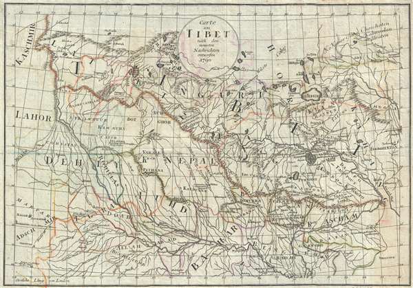
This is a remarkable and rare 1790 map of Tibet, a milestone in the mapping of that region, and one of the first maps of Tibet, Nepal, and Bhutan with any pretense at accuracy. The map was prepared by Paul Gotthelf Kummer to illustrate Matthias Christian Sprengel and Johann Reinhold Forster's Neue Beiträge zur Völker- und Länderkunde (New Contributions to International and Geography). The map covers Tibet, Bhutan, Nepal, and parts of northern India. Bhutan, appearing in the lower right quadrant, is identified as Bramsong, Bramshion and Bredshiong. The title translates roughly to 'Tibet from all the latest information,' and is remarkable cartographic achievement given the largely unexplored an inaccessible nature of the region at the end 18th century.
Early European Mapping of Tibet
European mapping of Tibet was very limited until the 19th century. Jesuit and Capuchin missionaries were active in Tibet from the 17th century, but little of their information reached European cartographers, then primarily based in Amsterdam, until the 18th century. Guillaume De L'Isle published the first map of Central Asia to have any ready detail from these missions in 1706, naming several actual sites in Tibet that had no mention on earlier maps, including Ü-Tsang, Lhasa, and Kuti (Nyalam), among others. Nonetheless, although De L'Isle knew that such places existed, he had no idea of their placement, which was pure speculation. Jean Baptiste Bourguignon d'Anville, another French cartographer, relying on later Jesuit missionaries who mapped Tibet from China, produced a superior and far more accurate map, which accompanied his 1737 Nouvel Atlas de la Chine. Afterwards, mapping attempts from India, ordered by James Rennell, improved geographical knowledge of adjoining Nepal and Bhutan. Similarly, the French cartographer and missionary, Joseph Tiefenthaler, with his detailed mapping of the rivers of upper India and speculations on the sources of the Brahmaputra and Ganges, also added to the cartographic picture. Later, in the early 18th centuries, cartographers, disguised as humble monks, worked their way into Tibet, with surveying tools disguised inside prayer wheels and other tools of Buddhist monastic tradition, produced a more accurate survey of the region.
An unrecognized milestone in mapping of Tibet
It is thus not by chance alone that Sven Heiden focused on this unusual map of Tibet, rarely seen today, as significant and as his starting point for the modern mapping of the region. The cartographer here, for the first time, synthesizes the cartographic work of D'Anville, Rennell, and Tiefenthaler, into a systematic whole superior to any earlier map of Tibet. That this map is not counted as one of the great cartographic milestones in the development of a sound cartographic overview of Tibet, Nepal, and Bhutan, is due solely to its extreme rarity.
Sven Heiden's Description of the Map
The inestimable Sven Heiden references it as one of the earliest maps of Tibet to contribute real geographical knowledge, and describes the map in detail, in his Southern Tibet: Discoveries in former times compared with my own researches in 1906-1908, in Volume VII of History of the Exploration in the Kara-Koraum Mountains (Leipzig, 1922) (Chapter XIII).
Before proceeding any farther in our historical account, we have to consider a few maps embracing a period of 30 years, or from 1790 to 1819. Of a few of these maps which seemed to be of greater interest than the rest, I have reproductions made. . . . I have only picked out a few which would give quite a sufficient idea of the cartographical picture of Tibet at this epoch. I begin with a German map, the original of which is to be found at the State Library of Berlin. Its title is: 'Carte von Tibet nach den neuesten Nachrichten entworfen 1790' (PI. XIII). It is a very rough and clumsy sketch from a technical point of view, but it is interesting as a representation of geographical detail. The sources are not mentioned but, as far as Tibet is concerned, we easily find traces of D'Anville, Tieffenthaler and Rennell. On the Upper Indus we find Tschasircong, Latak and Pitoc exactly as on d'Anville's map, and the river joins the branch from the lakes forming the Ganges, though the name 'Ganga ou Fleuve', is not entered on the river which in reality is the Sadej. On the latter, Latang, Tsaprong and Tschumurti are entered. North of the Latak River, which in reality is the Upper Indus, there is a latitudinal range of hills, from which a ramification is directed N. E. with Rutuh on its southern and See Tsarin on its northern side; exactly like d'Anville.This map is rare, with only 2 other examples, at Harvard's Pusey Library and at the Herzogin Anna Amalia Bibliothek in Weimar, Germany. According to Sven Heiden, another exists in the State Library of Berlin, although we have not been able to positively identify the catalog record. The map was issued by Paul Gotthelf Kummer in Leipzig to illustrate Matthias Christian Sprengel and Johann Reinhold Forster's Neue Beiträge zur Völker- und Länderkunde.
The eastern continuation of the principal range is called Kiangli oder Kangli Berge, corresponding to d'Anville's Kiancri M., all three of course standing for Kangri or Ice Mountain, usually written Gangri. The sources of the Tsangpo or Brahmaputra are taken from d'Anville; even the Nauk. is present.
In this general situation created by the Lamas of Kang Hi and digested by D'Anville, the map of 1790 has adopted the hydrographical views of Tieffenthaler, so far as the two famous lakes are concerned.' But Tieffenthaler makes the Satlej take its origin from Mansaroar (See Mansaroar oder Mapang on the map), whereas the map of 1790 combines Tieftenthaler and d'Anville, and lets the Satlej of the former be the same river as the Ganga of the latter. The river from the Lanka Dhe is in both cases the Gagra. The temple of Mahadeo, i. e. Tugu-gompa is adopted. On the other hand the draftsman has not been able to accept the bifurcation of Tieffenthaler, who lets the Brahmaputra take its origin from Manasarovar. In this case he finds it more safe to follow d'Anville. The regions farther east are all taken from the French cartographer.
Cartographer
Paul Gotthelf Kummer (December 29, 1750 - February 25, 1835) was a Leipzig based German bookseller, printer, engraver, and publisher. Kummer was born in Mutzschen, near Freiberg, the son of pastor Georg Friedrich Kummer (1708-1771) and Christiana Elisabeth. He apprenticed in the book trade under Johann Samuel Heinsius the Younger (1734-1807) and afterwards worked with the bookseller Johann Gottfried Dyck in Leipzig. He opened his own Leipzig commission bookshop in 1776 and, meeting with some success by 1777, took over the Saalbach Publishing House. By 1800 he was well established and married Sophie Cichorius (1800), sister of the well-respected professor of anatomy in Dorpat Ludwig Emil Cichorius (1740-1829). Around 1813 he expanded again, acquiring the Stahl'schen Bookstore in Jena. Kummer was socially popular in academic circles and was regarded as 'honest and true-hearted, at times a little primitive.' and his wife had 11 children, of which Eduard Kummer inherited his bookstore, which he ran until his death in 1860. More by this mapmaker...
Source
Forster J. R., and Sprengel, Matthias C., Neue Beiträge zur Völker- und Länderkunde, (Leipzig) 1790.
Condition
Very good. A few minor verso reinforcements. Old color.
References
OCLC 646404224. Harvard University, HOLLIS, 012523074.