
This item below is out of stock, but another example (left) is available. To view the available item, click "Details."
Details
1913 Crow City Map or Plan of Tianjin / Tientsin, China
1921 (undated) $220.00
1915 Japanese Bi-lingual Railway Map of Tientsin or Tianjin, China
Tientsin-japanese-1915$100.00

Title
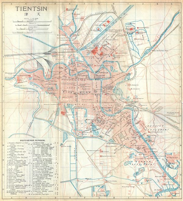
Tientsin.
1915 (undated) 11.5 x 10.5 in (29.21 x 26.67 cm) 1 : 35000
1915 (undated) 11.5 x 10.5 in (29.21 x 26.67 cm) 1 : 35000
Description
This is an appealing 1915 bi-lingual railway map if Tientsin or Tianjin, China, issued by the Imperial Japanese Government Railways. The map depicts Tianjin, the fourth most populous city in China, in great detail. Several streets, individual buildings, rivers, railways and other topographical features are noted. This map was issued as part of An Official Guide to Eastern Asia Trans-Continental Connections between Europe and Asia Vol. IV China and printed at the Tokyo Tsukiji Type Foundry in 1915. All text is in English and Chinese.
Source
The Imperial Japanese Government Railway, An Official Guide to Eastern Asia Trans-Continental Connections between Europe and Asia Vol. IV China, 1915.
Condition
Very good. Minor wear along original folds. Printed on thin paper.