This item has been sold, but you can get on the Waitlist to be notified if another example becomes available, or purchase a digital scan.
1548 Gastaldi Map of The East Coast
TierraNueva-gastaldi-1548$4,000.00


Title
Tierra Nueva.
1548 (undated) 5 x 6.75 in (12.7 x 17.145 cm)
1548 (undated) 5 x 6.75 in (12.7 x 17.145 cm)
Description
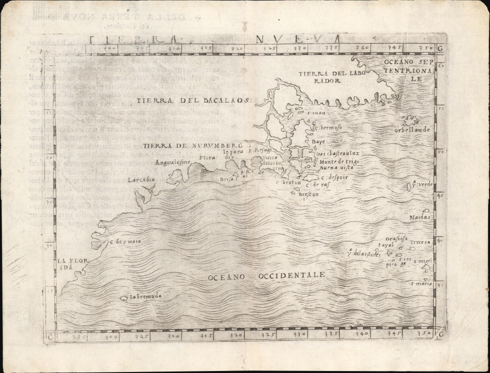
This is Giacomo Gastaldi's 1548 map of the eastern coast of North America. It is considered the first printed map specifically of the American eastern coastline and the first obtainable map to illustrate Narragansett Bay, Block Island, New York Harbor, Long Island, the Outer Banks, and Bermuda.
A few years later, in 1562, an English slave ship wrecked in the Gulf of Mexico. David Ingram, one of the survivors, claimed to have trekked overland from the Gulf Coast to Nova Scotia, where he was rescued by a passing French ship. Possibly inspired by Mexican legends of El Dorado, Cibola, and other lost cities, Ingram returned to Europe to regale his drinking companions with boasts of a fabulous city rich in pearls and built upon pillars of crystal, silver, and gold. The idea caught on in the European popular imagination, and expeditions were sent to search for the city - including that of Samuel de Champlain.
The legend of Norumbega thus seems to have transitioned from Allefonsce's most likely factual description of a lively American Indian trading center to Thevet's French trading post to Ingram's fabulous paradise of dripping wealth. Allefonsce's description of the American Indians he encountered in Norumbega corresponds well with those of Hudson, who also met a tall, well-proportioned people. Sadly, only a few years later, many of these tribes began to die off at extraordinary rates (over 90% of the population perished) due to outbreaks of smallpox and other diseases carried by the unwitting European explorers. It seems reasonable that Allefonsce may have stumbled upon a periodic or semi-permanent indigenous fur trading center on the Penobscot. It also seems reasonable that French colonists may have set up their fur trading post at the same site, for it was fur, not gold, that was the real wealth of New England and Norumbega. Alas, it was Ingram's fictitious account, though wholly the product of a drunken sailor's imagination, that produced the most enduring image of Norumbega.
A Closer Look
Coverage embraces the eastern coastline of North America from roughly upper Florida north past Cabo de Santa Maria to Larcadia (Kitty Hawk), Angoulesme (New York Harbor), Narragansett Bay, Newfoundland, Nova Scotia, and Labrador. The territory is divided into four distinct regions: Tierra del Labrador, Tierra del Bacalaos, Tierra de Nurumberg, and La Florida. There is no additional inland detail, reflecting the extent to which this remained an unknown territory.Understanding the Toponomy
Cartographically, this map offers a fascinating look at early cartographers' attempts to reconcile the discoveries of Giovanni Verrazzano with those of Jacques Cartier. Based upon 20th-century readings of the Cellere Codex, a contemporaneous account of Verrazzano's voyage, we can interoperate the toponomy thus:- Arcadia - Named by Verrazzano for its forested beauty, now assumed to have been somewhere near Kitty Hawk.
- Angoulesme - The place name Verrazzano gave to New York Harbor (although Andre Thevet, writing in 1550, also took credit for the term).
- Flora - Most likely the south coast of Long Island.
- Brisa - Block Island.
- Pt. Refuge - Narragansett Bay.
Verrazzano and Cartier
Gastaldi's efforts to connect and reconcile the discoveries of Giovanni Verrazzano and Jacques Cartier run afoul of the fact that Cartier's voyage did not reach as far south as Verrazzano's did north, with the result that a vast swath of New England is omitted from the present work. Cartier never sailed south of Prince Edward Island, and Verrazzano barely skirted the southern tip of Nova Scotia; thus, 'C. Breton' (Cape Breton Island) appears where one might expect to find Cape Cod. The mass of islands and rivers, with names like 'Isola de Demoni' (Island of Demons) and 'Terra Nova,' is an early effort to comprehend the coast of Maine around the Penobscot River, Nova Scotia, Newfoundland, the Gulf of St. Lawrence, and Labrador. Labrador, here labeled as 'Tierra del Labrador,' is vaguely recognizable. 'Orbellanda,' a term derived from Arthurian legend, is similarly recognizable as Newfoundland. Both reference Cartier's explorations.Nurembega - the El Dorado of New England
Of some interest is the land of Noranbega (Nurembega), located here just north of Long Island. This mysterious land appeared on maps of New England as early as Verrazano's 1529 manuscript. He used the term 'Oranbega,' which in Algonquin means 'lull in the river.' The first detailed reference to Noranbega, or as it is more commonly spelled Norumbega, appeared in the 1542 journals of the French navigator Jean Fonteneau dit Alfonse de Saintonge. Allefonsce was a well-respected navigator who, in conjunction with the French nobleman Jean-François de la Roque de Roberval's attempt to colonize the region, skirted the coasts south of Newfoundland in 1542. He discovered and sailed some distance up the Penobscot River, encountering a fur-rich American Indian city named Norumbega - somewhere near modern-day Bangor, Maine.The river is more than 40 leagues wide at its entrance and retains its width some thirty or forty leagues. It is full of Islands, which stretch some ten or twelve leagues into the sea... Fifteen leagues within this river there is a town called Norombega, with clever inhabitants, who trade in furs of all sorts; the town folk are dressed in furs, wearing sable.... The people use many words which sound like Latin. They worship the sun. They are tall and handsome in form. The land of Norombega lies high and is well situated.Though Roberval's colony lasted only two years, Andre Thevet, writing in 1550, records encountering a French trading fort at the site of Norumbega.
A few years later, in 1562, an English slave ship wrecked in the Gulf of Mexico. David Ingram, one of the survivors, claimed to have trekked overland from the Gulf Coast to Nova Scotia, where he was rescued by a passing French ship. Possibly inspired by Mexican legends of El Dorado, Cibola, and other lost cities, Ingram returned to Europe to regale his drinking companions with boasts of a fabulous city rich in pearls and built upon pillars of crystal, silver, and gold. The idea caught on in the European popular imagination, and expeditions were sent to search for the city - including that of Samuel de Champlain.
The legend of Norumbega thus seems to have transitioned from Allefonsce's most likely factual description of a lively American Indian trading center to Thevet's French trading post to Ingram's fabulous paradise of dripping wealth. Allefonsce's description of the American Indians he encountered in Norumbega corresponds well with those of Hudson, who also met a tall, well-proportioned people. Sadly, only a few years later, many of these tribes began to die off at extraordinary rates (over 90% of the population perished) due to outbreaks of smallpox and other diseases carried by the unwitting European explorers. It seems reasonable that Allefonsce may have stumbled upon a periodic or semi-permanent indigenous fur trading center on the Penobscot. It also seems reasonable that French colonists may have set up their fur trading post at the same site, for it was fur, not gold, that was the real wealth of New England and Norumbega. Alas, it was Ingram's fictitious account, though wholly the product of a drunken sailor's imagination, that produced the most enduring image of Norumbega.
Publication History and Census
This map was engraved by Gastaldi in Venice in 1548. It appears in a single edition in La Geografia. Well represented institutionally but scarce on the market.Cartographer
Giacomo Gastaldi (c. 1500 - October, 1566) was an Italian astronomer, cartographer, and engineer active in the second half of the 16th century. Gastaldi (sometimes referred to as Jacopo or Iacobo) began his career as an engineer, serving the Venetian Republic in that capacity until the fourth decade of the sixteenth century. During this time he traveled extensively, building a large library relating to voyages and exploration. From about 1544 he turned his attention to mapmaking, working extensively with Gextantiovanni Battista Ramusio, Nicolo Bascarini, and Giovanbattista Pedrezano, as well as taking private commissions for, among others, Venice's Council of Ten. He is credited with the fresco maps of Asia and Africa still extant in the map room of the Doge's Palace. Gastaldi was also one of the first cartographers to embrace copper plate over woodblock engraving, marking an important development in the history of cartography. His 1548 edition of Ptolemy's Geographia was the first to be printed in a vernacular; it was the first to be printed in copperplate. As with his Swiss/German contemporary Münster, Gastaldi's work contained many maps depicting newly discovered regions for the first time, including the first map to focus on the East Coast of North America, and the first modern map of the Indian Peninsula. His works provided the source for the vast majority of the Venetian and Roman map publishers of the 1560s and 70s, and would continue to provide an outsize influence on the early maps of Ortelius, De Jode, and Mercator. More by this mapmaker...
Source
Gastaldi, G., La Geografia, (Venice: Pedrezzano) 1548.
Giacomo Gastaldi's 1548 La Geografia was one of the most important early editions of Claudius Ptolemy's foundational geographical work. It was the first small-format, portable edition of a Ptolemy, and the first of the 16th century to be executed with copperplate maps. It was the most complete, modernized, edition of Ptolemy yet attempted, with 34 tabulae modernae included to correspond with the classic 26 Ptolemaic maps. Of the first Ptolemies, Gastaldi's 1548 work was the first to include separate regional maps of the Americas, most notably a map of the American east coast derived from the explorations of Verrazzano and Cartier. Perhaps most importantly, Gastaldi's Ptolemy was the first to be published in a vernacular language, Italian. This work is a testament to the humanist correspondence of the 16th century: many of the modern maps were derived from those of the German-Swiss geographer Sebastian Münster, who provided Gastaldi with commentary in the text of the new translation as well. Although Gastaldi's Ptolemy would only be published in one edition, it provided the basis for Girolamo Ruscelli's editions beginning in 1561.
Condition
Very good. Centerfold wear. Minor wormhole repair upper margin. Printer's crease, lower right corner. Weak impression, upper left corner.
References
Burden, P., The Mapping of North America, #16. Palmer, M., Mapping of Bermuda, A Bibliography of Printed Maps and Charts 1548-1970, p. 4, 14. McCorkle, B. B, New England in Early Printed Maps 1513 - 1800, #548.1. Suarez, T., Shedding the Veil, #25.