This is a 1943 Ernest Dudley Chase pictorial map of the world during World War II (1939 - 1945). It is one of a series of maps Chase produced to illustrate the war as it developed.
A Closer Look
The map depicts the world with political boundaries predating the war. Approximate distances between New York and points worldwide, such as Sydney, Melbourne, Manila, and Bombay, are provided. Symbols mark global naval bases and possessions of the British, Americans, Japanese, French, and Dutch. Illustrations of submarines, battleships, and even an ocean liner fill the seas while American fighter and bomber aircraft patrol the skies. Vignettes appear along the top and bottom borders and illustrate a tank, artillery pieces, a B-17 Flying Fortress, and anti-aircraft gun mounts aboard a Navy ship. Morse Code for the letter 'V' (for 'Victory') of three dots and a dash create the border.The Verso: The Victory War Map
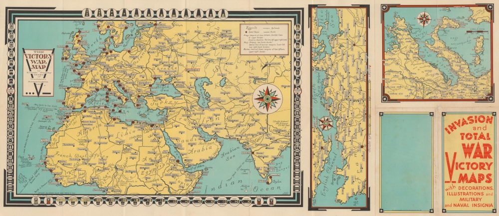
The Victory War Map occupies over half of the verso and depicts from southern Scandinavia to central Africa and from the Atlantic Ocean to India. Anchors mark naval bases. Cities are labeled throughout, with small crosses marking capitals. Railroads wind across Europe and Asia into the Indian Subcontinent. Very few railroads are illustrated in Africa. Insignia of the U.S. Army, Navy, and Marine Corps appear on the border. Two smaller maps appear to the right. One illustrates the northern coast of continental Europe from Brittany to the Jutland Peninsula. This vast region was presumed to be the theater of the expected Allied invasion of continental Europe, but no one knew exactly where or when that would occur. The other smaller map focuses on Italy, Sicily, the Adriatic Sea, and the Balkans. The Allies invaded Italy in the fall of 1943, which made this region's geography of even greater interest to Chase's audience.Publication History and Census
This map was created and published by Ernest Dudley Chase in 1943 with the 1942 'Total War Battle Map' on the recto. We note an example of the present map in the David Rumsey Map Collection. One example is cataloged in OCLC, which is part of the collection at the National Library of Australia.
Cartographer
Ernest Dudley Chase (July 26, 1878 - August 25, 1966) was an American illustrator of greeting cards and pictorial maps active in the first half of the 20th century. From his studio in Winchester, Massachusetts, Chase became famous for his elaborately illustrated pictorial maps. He was born in Lowell, Massachusetts, and attended the Lowell Textile School and the Vesper George Art School. He took work with Butterfield Printing Company in 1900. In 1906, he moved to the W. T. Sheehan Printing Firm. He began producing postcards and greeting cards on his own account in 1908. This initial imprint was Des Arts Publishers, but later, he changed it to Ernest Dudley Chase Publishers. Chase is best known today for his distinctive pictorial maps, most of which he published privately, characterized by dense vignette images of important locations. The biographical pamphlet A Meticulous Maker of Maps describes Chase's attention to detail wherein, pursuing a 'passion for perfection' by stippling his images 'dot-by-dot, with tiny pens' under a magnifying glass. His impressive corpus includes nearly 50 maps focusing on various parts of the United States and Europe, as well as other international locations and novelty pieces. Most are thematic, focusing on topics such as wonders of the world, stamps, aviation, and war. Others, such as his map of The United States as viewed by California and Loveland are satirical. All, in their original editions, are coveted by a dedicated following of modern collectors. More by this mapmaker...
Very good. Light wear along original fold lines. Verso repairs to fold separations at 2 fold intersections. Slight loss at 2 fold intersections. The Victory War Map on verso.
Rumsey 8702.002 and 8702.003. OCLC 421766867.