1789 Conder Map of the American Colonies, Anburney's Account of the American Revolution
TravelsAmerica-anburey-1789$3,000.00


Title
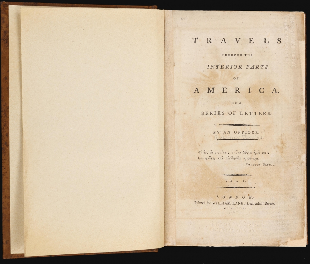
Map for the Interior Travels through America delineating the March of the Army. / Travels through the interior parts of America. In a series of letters. By an officer.
1789 (dated) x in (0 x 0 cm)
1789 (dated) x in (0 x 0 cm)
Description
A fine example of Thomas Conder's 1789 map of the American colonies and the accompanying 2-volume Thomas Anburey travelogue. The fascinating work, Travels Through the Interior Parts of America. In a Series of Letters. By an Officer, records Anburey's travels in Canada and the former British Colonies in North America.
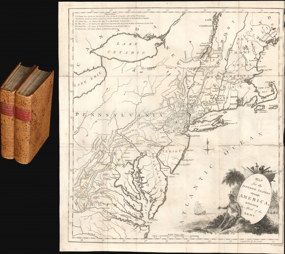
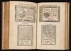
Aside from the marches, towns, settlements, and forts are noted throughout, including those that were significant to the conflict, such as Valley Forge, Fort Ticonderoga, and Saratoga. Mountains are illustrated, and major waterways are labeled, often with spellings that would become atypical in the following years (such as 'Potowmack River'). The decorative cartouche at bottom-right presents a Native American resting with a musket, gesturing towards a ship off the coast, sailing away (perhaps a representation of Britain's flagging prospects in the New World), and a group of soldiers (presumably British, perhaps Anburey's woebegone Convention Army) at right.
We note 4 examples of the separate map cataloged in OCLC, which are part of the collections at the Library of Congress, the Boston Athenaeum, Brown University, and the Library of Virginia. The book is well represented in institutional collections across the United States and Canada, though OCLC records comingle physical examples with microform and digital copies, making a census difficult to establish.
A Closer Look - A Map and a Travelogue
The map depicts from Casco Bay in Maine south to Norfolk and the James River and from Stanton, Virginia, east to the Atlantic Ocean. Created to accompany Anburey's book, the map highlights 6 marches (listed at top-left) he made during his time in the American Colonies during the American Revolutionary War. Anburey's book consists of a series of letters from before landing in Canada through the Saratoga Campaign, his captivity as a prisoner of war, his parole, and his return to England. Chronologically, the first route highlights the marches of the British Army during the Saratoga Campaign, when Anbury served as an officer under General John Burgoyne. After Burgoyne's surrender at Saratoga on October 17, 1777, Anburey became part of the Convention Army, the remnants of Burgoyne's troops (nearly 6,000 at the outset), that were marched to and fro throughout the colonies in the following years, suffering from disease and miserable conditions in the process, until the conflict's end. However, unlike rank-and-file troops, as an officer, Anburey was included as part of a prisoner exchange in 1781 and returned to England.Aside from the marches, towns, settlements, and forts are noted throughout, including those that were significant to the conflict, such as Valley Forge, Fort Ticonderoga, and Saratoga. Mountains are illustrated, and major waterways are labeled, often with spellings that would become atypical in the following years (such as 'Potowmack River'). The decorative cartouche at bottom-right presents a Native American resting with a musket, gesturing towards a ship off the coast, sailing away (perhaps a representation of Britain's flagging prospects in the New World), and a group of soldiers (presumably British, perhaps Anburey's woebegone Convention Army) at right.
Controversy
From the time of publication, the veracity of Anburey's account has been questioned. The subscriber's list was noted as being decidedly anti-American, noted The Monthly Review, which also cited a passage that was lifted wholesale from the Annual Register, a yearly record of history, literature, and politics. Another publication, The Critical Review, stated, 'From a careful comparison we can pronounce this work, in its most essential parts, to be an ill-digested plagiarism from general Burgoyne's Narrative, and from the Account of the Prosecution of Colonel Henley.' Anburey also 'borrowed' liberally from Andrew Burnaby's Travels through the Middle Settlements in North-America, the Narrative of John F. D. Smyth. However, these early charges were mainly ignored, and the book became an essential source concerning Burgoyne's American expedition. Over time, scholars revived questions about the authenticity of Anburey's writing. In a 1943 study, Whitfield Bell found over 60 'borrowed' passages from over a dozen sources. Canonical texts such as Wright Howes U.S.IANA, 1650-1950 similarly wrote off Anburey's account as plagiarism. There is even doubt about whether or not Thomas Anburey was a real person. A Thomas Anbury (without the e) appears in a few British military records and an Ensign Hanbury (no first name) is in Burgoyne's Orderly Book in August 1777. The signature of a British officer, Thos. Anbury, appears in the Parole of Honor, Cambridge, December 13, 1777. Other than that, Anburey has disappeared from the historical record. Nevertheless, some historians have found use for the non-plagiarized portions of the text, whatever the identity of their author, for providing additional granular detail on the attitudes prevalent in the colonies in the early phase of the revolution.Publication History and Census
This map was drawn and engraved by Thomas Conder and published in 1789 in Thomas Anburey's book Travels Through the Interior Parts of America. In a Series of Letters. By an Officer. The original 1789 publication of Anburey's book was followed by a French edition (Voyage dans les parties intérieures de l'Amérique septentrionale…, 1790), a German edition (Reisen im Inneren von Nordamerika…, 1792), and a second French edition (Journal d'un voyage fait dans l'intérieure de l'Amérique septentrionale…, 1793). Anburey's book should not be confused with Jonathan Carver's Travels through the interior parts of North-America, documenting a trip in the late 1760s, which was also published in several editions on both sides of the Atlantic in the 1780s and 1790s.We note 4 examples of the separate map cataloged in OCLC, which are part of the collections at the Library of Congress, the Boston Athenaeum, Brown University, and the Library of Virginia. The book is well represented in institutional collections across the United States and Canada, though OCLC records comingle physical examples with microform and digital copies, making a census difficult to establish.
Cartographer
Thomas Conder (1747 - June 1831) was an English map engraver and bookseller active in London during the late 17th and early 18th centuries. From his shop at 30 Bucklersbury, London, Conder produced a large corpus of maps and charts, usually in conjunction with other publishers of his day, including Wilkinson, Moore, Kitchin, and Walpole. Unfortunately few biographical facts regarding Conder's life have survived. Thomas Conder was succeeded by his son Josiah Conder who, despite being severely blinded by smallpox, followed in his father's footsteps as a bookseller and author of some renown. More by this mapmaker...
Condition
Very good. Two volumes, rebound in full mottled calf, period style. Vol 1, 467 pages. Vol 2, 538 pages. Archival repairs to first two pages of volume 1, including the title page. Two torn pages, 241/242 of volume 2, and 135/136 of volume 1. Some stains to pages, volume 1, pages 119 - 123. All called for illustrations present. Light foxing here and there. Title pages of both volumes bear blindstamps from Trinity College Library Burlington Vermont and Mark Skinner Library, Manchester, Vermont. The Mark Skinner Library, the last to hold this map, closed its doors in 2014 and is now a fine dining restaurant. Map and all other fold-out illustrations are laid down on older linen. Most exhibit wear on old fold lines. Map exhibits minor damage along centerfold.
References
OCLC 5408594. Sabin, J., A Dictionary of Books Relating to America: from its Discovery to the Present Time, 1366-67. TPL 541. Bibliotheca Americana (Stevens), p. 27. Howes, W., U.S.iana (1650-1950): A Selective Bibliography in which are Described 11,620 Uncommon and Significant Books Relating to the Continental Portion of the United States, A-226. Dunning, E., 'Thomas Anburey at the Battle of Hubbardton: How a Fraudulent Source Misled Historians,' Vermont History Vol. 78, No. 1 (Winter/Spring 2021) Vermont Historical Society.