1590 Adrichem Map of Tribe of Asher, Israel (Western Galilee, Mount Hermon)
TribeAser-adrichem-1590$500.00

Title
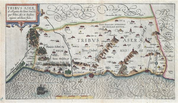
Tribus Aser id est, portio illa Terrae Sancta, quae Tribui Aser in diuisione regionis attributa fuit.
1590 (undated) 9 x 16 in (22.86 x 40.64 cm) 1 : 350000
1590 (undated) 9 x 16 in (22.86 x 40.64 cm) 1 : 350000
Description
This is a beautiful example of Christian van Adrichom's rare 1590 map of the lands granted to the Tribe of Asher at the time of Joshua's division of the Twelve Tribes. The map is oriented to the east and covers western Galilee from the city of Acre (called Ptolemais or Acon in ancient times) northward past the city of Tyre (Tyrus) toward Sidon and Mouth Hermon. A number of important biblical sites are identified pictorially including the site of the episode of Saint George and the Dragon where Saint George, the brave martyr, kills a dragon (signifying the devil) to rescue a princess (signifying God's Holy Truth). After the Kingdom of Israel was conquered by Assyria, the northern tribes including Dan, Ephraim, Manasseh, Asher and Zebulun were spared. The tribe of Asher would return to worship at the Temple of Jerusalem.
This map is the first of ten maps of the Holy Land prepared by Christian van Adrichem for publication in his Theatrum Terrae Sanctae. Adrichem's maps for the Theatrum were prepared between 1580 and 1585, but were published posthumously by his associate, Gerardis Brunius of Koln, in 1590. The publication went through several later editions and served as a basis for most subsequent maps of the Holy Land well into the 18th century.
This map is the first of ten maps of the Holy Land prepared by Christian van Adrichem for publication in his Theatrum Terrae Sanctae. Adrichem's maps for the Theatrum were prepared between 1580 and 1585, but were published posthumously by his associate, Gerardis Brunius of Koln, in 1590. The publication went through several later editions and served as a basis for most subsequent maps of the Holy Land well into the 18th century.
Cartographer
Christian Kruik van Adrichem (February 13, 1533 - June 20, 1585), alternatively known as Christianus Crucius Adrichomius was a Dutch theologian active in the second half of the 16th century. Adrichem was born in Delft of a wealthy family - at one point his father, Adriaen Claesz, was mayor of Delft. Adrichem was ordained in 1566. He served as the director of the Convent of St. Barbara in Delft until expelled by the Protestant Reformation. Fleeing the anti-Catholic sentiment of the Reformation, Adrichem reestablished himself in Cologne (Koln) where compiled various religious works including his important historical atlas, the Theatrum Terrae Sanctae et Biblicarum Historiarum. Adrichem's important atlas was published posthumously by his associate Gerardis Brunius in 1590. The work went through numerous editions and served as the foundation of most subsequent maps of the Holy Land well into the 18th century. More by this mapmaker...
Source
Adrichem, Christian van, Theatrum Terrae Sanctae et Biblicarum Historiarum (Gerardus Brunius, Koln) 1590.
Condition
Very good. Original platemark visible. Blank on verso. Minor wear along original fold lines.
References
Laor, E., Maps of the Holy Land: Cartobibliography of Printed Maps, 1475 - 1900, #9.