This item has been sold, but you can get on the Waitlist to be notified if another example becomes available, or purchase a digital scan.
1822 Admiralty Chart of Newfoundland from Trinity Harbor to Cape Freels
TrinityFreels-admiralty-1822$1,000.00


Title
A Survey of the Coast of Newfoundland from Trinity Harbour to Cape Freels.
1822 (dated) 31.5 x 24.5 in (80.01 x 62.23 cm) 1 : 1478340
1822 (dated) 31.5 x 24.5 in (80.01 x 62.23 cm) 1 : 1478340
Description
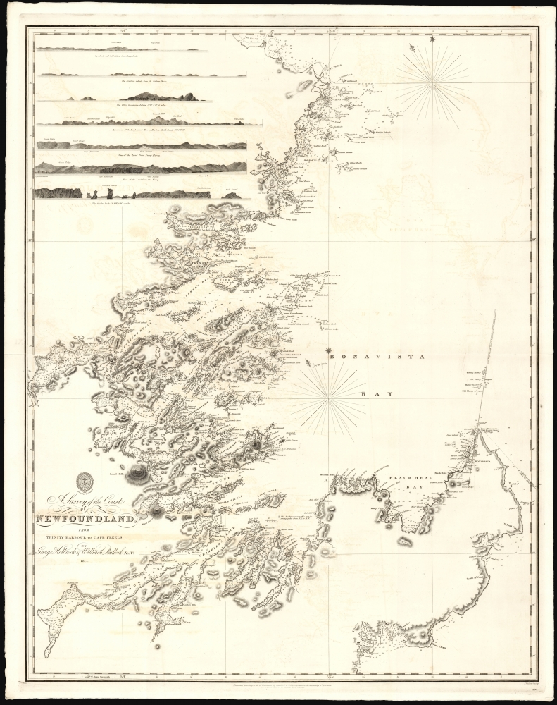
This is a large and rare 1822 British Admiralty Hydrographic Office nautical map of the east coast of Newfoundland, from Trinity Harbor to Deadman's Bay. It follows in the wake of the 1818 Rush-Bagot Agreement, which redefined shipping and fishing rights between America and Great Britain off the coast of Newfoundland and in the Grand Banks in the wake of the war of 1812.
A Closer Look
The chart contains the fruits of exhaustive 1917 coastal surveys by George Papps Holbrook and William Bullock. It focuses primarily on Bonavista Bay and the baffling fjords from Chandler Reach to Indian Bay, including today's Terra Nova National Park. The chart incorporates a multitude of soundings (fathoms), anchorages, hazards, and shallows. In the upper left are seven beautifully executed coastal profiles, keyed to specific locations on the chart. As is typical of Admiralty charts, coastal detail pertaining to heights along the littoral is indicated with hachure. The chart is graced with an elegant compass rose, indicating the magnetic variation for the year 1820.Diplomatic Context
The need to survey these waters sharpened in the wake of the War of 1812 (1812 - 1815). While the Rush-Bagot Agreement (April 28 and 29, 1817; ratified in 1818) is primarily noted for its historic arms limitations on the Great Lakes and Lake Champlain, it also confirmed the right of the United States to fish off the coasts of Labrador and Newfoundland, necessitating the need for a host of new charts.Publication History and Census
This nautical map was published by the British Admiralty's Hydrographic Office in 1822 (number 293), having been engraved by the prolific John Walker (fl. 1783 - 1831). We are aware of one example of this chart surviving in institutional collections: the British Library. We see no prior record of it on the market.CartographerS
William Bullock (January 12, 1797 - March 7, 1874) was a British naval officer, clergyman, and hymn writer. He was born in Essex, England, and died in Halifax, Nova Scotia. He was educated at a Bluecoat School (a school for the poor) in London. He entered the navy in 1815, during which he saw active duty in the bombardment of Algiers in 1816. Eventually, he became sailing master's mate and assistant surveyor aboard the Brig Snap, which did extensive hydrographic surveys around the coasts of Newfoundland - some in conjunction with George Papps Holbrook, future Surveyor General of Newfoundland. His ill health led to his discharge from the navy in 1821. During his service in Newfoundland, he came to believe the spiritual needs of the people of Newfoundland were not being met, and following his discharge, he chose to stay on in Newfoundland as a missionary for the Society for the Propagation of the Gospel. Bullock was ordained deacon in 1822 and raised to the priesthood two weeks later. He was appointed missionary at Trinity Bay, Newfoundland, in 1822. In 1823 he married Mary Clinch, daughter of the former missionary at Trinity; they had ten children. Bullock remained in Trinity as a successful and popular pastor, doctor, and magistrate until 1840. In 1841, he moved on to join a mission in Digby, Nova Scotia, where he built four new churches. He would become curate of St. Paul's Cathedral in Halifax in 1847. Eventually, he was appointed dean of the new cathedral of St. Luke, where he finally settled. In 1854, he published a collection of 166 hymns, one of which ('We love the place, O God') would be incorporated into the official hymnbook of the Church of England. More by this mapmaker...
George Papps Holbrook (1770 - March 18, 1832) was a British hydrographic surveyor who lived and worked in Newfoundland and Nova Scotia. He was born in Cornwall, England. Between 1814 and 1820, as a master in the Royal Navy, Holbrook commanded the Brig Sydney in order to survey the east coast of Newfoundland; between 1817 and 1820, he was assisted by astronomical surveyor William Bullock. He later commanded the Brig Snap, but would be relieved of that command in 1821. 1822 saw the birth of a son in Halifax. By the time of his death, he had become Surveyor General of Newfoundland. Learn More...
Condition
Excellent. Some marginal soiling, else fine.