This item has been sold, but you can get on the Waitlist to be notified if another example becomes available, or purchase a digital scan.
1809 Heywood Nautical Map of Macao (Macau), China
TypaMacao-heywood-1809$3,750.00

Title
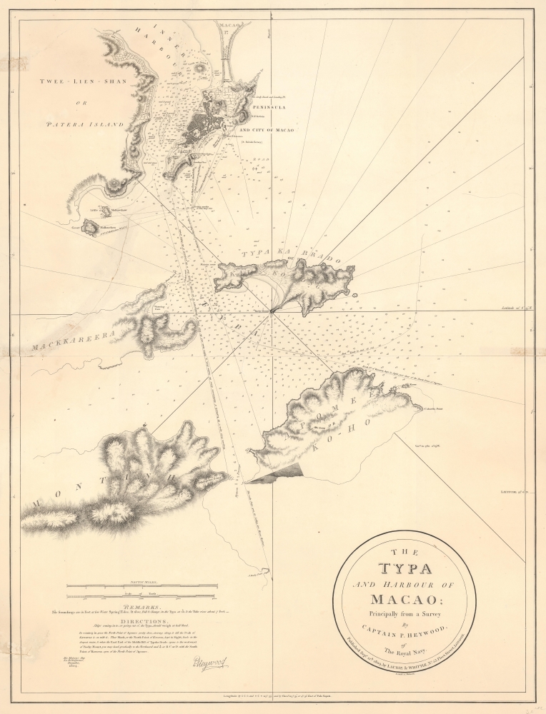
The Typa and Harbour of Macao; Principally from a Survey by Captain P. Heywood, of The Royal Navy.
1809 (dated) 28.75 x 22 in (73.025 x 55.88 cm) 1 : 24000
1809 (dated) 28.75 x 22 in (73.025 x 55.88 cm) 1 : 24000
Description
This is the only known example of the 1809 Laurie and Whittle first edition of Peter Heywood's seminal survey of Macau (Macao) and nearby Taipa. This survey, conducted independently while Heywood's ship, the La Dedaigneuse, was being refitted in Macau, is the most important mapping of Macau since the 1778-79 survey of Heywood's erstwhile hydrography instructor, captain, and lifelong nemesis, Captain William Bligh of Bounty infamy. The survey appeared in the context of the Napoleonic Wars, when Franco-Spanish fleets were plaguing East India Company (EIC) fleets, and the British were keen to establish a foothold in the Pearl River Delta. Taipa, being a long-established EIC mooring point, was the prime target.
With Goa and Macau threatened, the British pushed the Portuguese governors of Goa, who also technically administered far off Macau, to allow British forces to defend the colonies. Although unable to fully defend themselves, the Portuguese in Goa and Macau were reluctant to acquiesce to British aid, knowing it was but a stepping stone to losing their sovereignty. Goa ultimately accepted British reinforcements and sent orders for Macau to do the same. The fanatically Portuguese political powers in Macao, as well as the powerful and affluent Chinese merchant population, had other ideas, and infighting turned elements of the colonial government hostile to the British and French alike. Eager nonetheless to defend their trade interests, the British proceeded to patrol the waters around Macau.
When Heywood conducted his survey, the Taipa was not part of Macau and would have been considered fair game to the British. The British keenly desired a secure naval base in the Pearl River Delta, an area that, with ready access to Guangzhou (Canton), was considered key to the China Trade. Control of the Taipa would not only have given the British a defensible port but would also have allowed them to control access to Macao, potentially sidelining the Portuguese colony.
While critical to British economic and maritime interests, Heywood may have conducted the present 1804 survey on his own accord or perhaps at the instigation of British or Pro-British elements in Macau. Far from central authorities and without long-distance communication, Royal Navy captains were encouraged to think and act independently to secure British interests. According to the United Service Journal, Heywood's ship, La Dedaigneuse, lost its mast in a typhoon and was refitting in Macau when the surveys were conducted, presumably on a borrowed vessel.
It is of note that the title of the survey gives preeminence to the 'The Typa,' not to Macau, for it was the former that was of greater interest to the British, both as 'free' land and as a staging anchorage for East India Company ships.
In 1847, in the wake of the First Opium War (1839 - 1842) and the establishment of Hong Kong, Macau Governor João Maria Ferreira do Amaral sought to strengthen Portuguese control over Macau by annexing Taipa and constructing Taipa Fortress to defend against pirates. These actions were part of a broader strategy to expand Macau's territory, eventually incorporating Taipa, Ilha Verde, Coloane, and parts of Hengqin (Montanha) into the colony, solidifying Portugal's influence.
This is the only known example of the first edition. A later edition, with updates to 1855, is digitally archived in the Spanish Biblioteca Virtual del Ministerio de Defensa. However, it is unclear where their scan might have come from, as they do not record a physical holding. The British Admiralty published Heywood's survey in a completely new chart, with multiple updates, in 1840, followed by numerous subsequent editions. We also note in the British Library an 1860 map with a similar but modified title, also published by R. H. Laurie. There are no known examples of the present map.
A Closer Look
Coverage embraces from Macau's Inner Harbor and isthmus, south to include Colane and Dahengqin Islands. The meticulous comprehensiveness of the work underscores Heywood's excellent hydrographic training, likely under William Bligh. The hydrography is anchored to a control network of observed positions, enabling comprehensive sounding coverage. The focus and centerpiece of the survey is Taipa (Typa) Island, the primary gathering point for the annual British East India China fleets en route from Canton (Guangzhou) to Europe. 'The Typa' (Taipa) refers to both the island, here labeled Kaikong, and the passage between it and Mackkareenra Island (as here, today part of Hengqin (横琴岛)). The map features dense soundings illustrating the route from Macao's inner harbor through the narrow channel between Mackkareera and Typa Ka Brado (Kaikong), also called 'The Typa.' It highlights routes best followed to avoid the two large rocks that plagued ships navigating into Macao Harbor, Pedra Meo and Pedra Areeka. It also notes the 'Best Track in and out,' not to Macao, but to EIC anchorage points in the Typa Channel.Historical Context
Heywood's survey was conducted in the context of the Napoleonic Wars (1803 - 1815). Powerful Franco-Spanish fleets actively patrolled the Indian Ocean and East Indian waters in an attempt to disrupt the lucrative British East India Trade. Although generally avoiding direct attacks on well-defended British coastal forts, ships at sea were fair game. Moreover, the French recognized the significance of the long-standing Portuguese-British alliance and the critical nature of both Goa and Macau to the East India trade. French plans to seize Portuguese Diu (near Bombay) were leaked in 1796 and during the Macau Incident of 1799, French and British forces engaged in an abortive naval confrontation near Macau that threatened the annual East India China Fleet, transporting a combined wealth of nearly a 900,000,000 USD in modern terms.With Goa and Macau threatened, the British pushed the Portuguese governors of Goa, who also technically administered far off Macau, to allow British forces to defend the colonies. Although unable to fully defend themselves, the Portuguese in Goa and Macau were reluctant to acquiesce to British aid, knowing it was but a stepping stone to losing their sovereignty. Goa ultimately accepted British reinforcements and sent orders for Macau to do the same. The fanatically Portuguese political powers in Macao, as well as the powerful and affluent Chinese merchant population, had other ideas, and infighting turned elements of the colonial government hostile to the British and French alike. Eager nonetheless to defend their trade interests, the British proceeded to patrol the waters around Macau.
When Heywood conducted his survey, the Taipa was not part of Macau and would have been considered fair game to the British. The British keenly desired a secure naval base in the Pearl River Delta, an area that, with ready access to Guangzhou (Canton), was considered key to the China Trade. Control of the Taipa would not only have given the British a defensible port but would also have allowed them to control access to Macao, potentially sidelining the Portuguese colony.
While critical to British economic and maritime interests, Heywood may have conducted the present 1804 survey on his own accord or perhaps at the instigation of British or Pro-British elements in Macau. Far from central authorities and without long-distance communication, Royal Navy captains were encouraged to think and act independently to secure British interests. According to the United Service Journal, Heywood's ship, La Dedaigneuse, lost its mast in a typhoon and was refitting in Macau when the surveys were conducted, presumably on a borrowed vessel.
It is of note that the title of the survey gives preeminence to the 'The Typa,' not to Macau, for it was the former that was of greater interest to the British, both as 'free' land and as a staging anchorage for East India Company ships.
In 1847, in the wake of the First Opium War (1839 - 1842) and the establishment of Hong Kong, Macau Governor João Maria Ferreira do Amaral sought to strengthen Portuguese control over Macau by annexing Taipa and constructing Taipa Fortress to defend against pirates. These actions were part of a broader strategy to expand Macau's territory, eventually incorporating Taipa, Ilha Verde, Coloane, and parts of Hengqin (Montanha) into the colony, solidifying Portugal's influence.
Publication History and Census
This map is based on surveys of Macau and the Typa (氹仔/ Taipa) conducted by Peter Heywood in 1804 as captain of the H.M.S. La Dedaigneuse. The surveys remained unpublished until 1809 when this map was engraved by Benjamin Smith and published by Laurie and Whittle.This is the only known example of the first edition. A later edition, with updates to 1855, is digitally archived in the Spanish Biblioteca Virtual del Ministerio de Defensa. However, it is unclear where their scan might have come from, as they do not record a physical holding. The British Admiralty published Heywood's survey in a completely new chart, with multiple updates, in 1840, followed by numerous subsequent editions. We also note in the British Library an 1860 map with a similar but modified title, also published by R. H. Laurie. There are no known examples of the present map.
CartographerS
Peter Heywood (June 6, 1772 - February 10, 1831) was a British naval officer and hydrographer active in the late 18th and early 19th centuries. He was born in Douglas, Isle of Man, England. Heywood is best remembered for his association with William Bligh, the highly capable but notorious captain of the mutinous H.M.S. Bounty. At the beginning of the Bounty's fateful voyage, Bligh recognized Heywood, then just 15 and a family friend, along with Fletcher Christian, as smart and capable sailors, of which he wrote, 'These two had been objects of my particular regard and attention, and I had taken great pains to instruct them.' It is thus likely that Heywood was taught hydrography and marine surveying directly under Bligh. He was nonetheless among those who mutinied against Bligh on April 28, 1789 - Bligh's testimony even named him an instigator. He was captured in Tahiti, tried as a mutineer, condemned to death, and, in a remarkable twist of fate, pardoned, after which he returned to a long and privileged naval career. Historian Caroline Alexander suggests that Heywood suffered a sense of guilt over his pardon, knowing that he had 'perjured himself' in saying that he was kept below and therefore prevented from joining Bligh. He nonetheless remained in the Royal Navy for the next 29 years, putting Bligh's hydrographic training to good use in Ceylon (1803), India, Macao (1804), Morocco, South America, Sumatra, and northwestern Australia. His work received high praise from James Horsburgh, Hydrographer to the East India Company, who wrote that Heywood 'essentially contributed to making my Sailing Directory for the Indian navigation much more perfect than it would otherwise have been.' Heywood retired from Navy life in 1816, settling near Highgate, London. In retirement, he compiled a Tahitian language dictionary, compiled his papers, and corresponded widely with the luminaries of his generations, including Francis Beaufort and Charles Lamb. More by this mapmaker...
Richard Holmes Laurie (December 2, 1777 - January 19, 1858) was a British map and chart publisher and seller. Born in London to publisher Robert Laurie and his wife Esther Jouret, R. H. Laurie took over his father's share of the Laurie and Whittle publishing firm upon his father's retirement in 1812 and began trading as Whittle and Laurie. After Whittle died in 1818, Laurie continued the business by himself, trading under the imprint R. H. Laurie. During the 1820s and 1830s, Laurie expanded the nautical chart business until he was overtaken by Admiralty charts. Laurie married Susan Ann Coates on February 6, 1814 and later married Mary Ann Dennison on October 15, 1833. He left his business and all his property in trust for his two surviving daughters (both of whom were minors) with his principal engraver, Alexander George Findlay. Findlay continued the business in Laurie's name after acquiring its equity from his daughters. Learn More...
Benjamin Smith (1774 - 1817) was a British engraver and publisher active from about 1799 to his death in 1817. Smith was born in London to Benjamin Smith, the elder (1754 - 1833), also an engraver. He apprenticed as an engraver and stationer under Joseph Ellis. In 1799, he partnered with Edward Jones, publishing as alternatively 'Jones and Smith' or 'Smith and Jones.' Around 1801, a third partner, Joseph Bye, was added, and the imprint changed to 'Jones, Smith and Bye' or 'Jones Smith and Company.' Around 1804, the partnership dissolved as Smith and Bye were on their way to Portugal for business when their ship was seized by French privateers, and they were imprisoned in France for the next four years. Gaining their freedom in 1814, Smith and Bye jointly moved to Edinburgh where they took work as engravers for the William and Daniel Lizars firm. Meanwhile, they developed aliases as James Johnson and George Williams, under which they began issuing forged Margate Bank notes. They were arrested, convicted, and sentenced to death at Dover on November 3, 1817. Learn More...
Condition
Average. Laid on archival tissue to stabilize several large tears, including one running through the Inner Harbor to mid-page. Centerfold reinforcement.
References
Hariharan, S., 'Macao and the English East India Company in the Early Nineteenth Century: Resistance
and Confrontation', Portuguese Studies, 2007, Vol. 23, No. 2 (2007), pp. 135-152. Tagart, E., Memoir of the late Captain Peter Heywood, R. N., (1836), pages 173, 334.