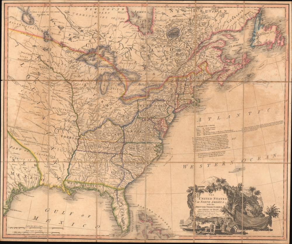
1809 Faden Map of the United States w/ State of Franklin and American Indian Rights
UnitedStates-faden-1809$6,500.00

Title
The United States of North America: with the British Territories and Those of Spain.
1809 (dated) 21 x 25 in (53.34 x 63.5 cm) 1 : 6350000
1809 (dated) 21 x 25 in (53.34 x 63.5 cm) 1 : 6350000
Description
This is Faden's 1808 map of the United States, representing the new nation as it was struggling to resolve issues of state vs. federal sovereignty, land rights, American Indian relations, domestic and foreign speculators, and frontier opportunism. It includes the ephemeral proto-state of Franklinia and the colony of New Iberia.
The present example is, according to the Stevens and Tree cartobibliography, the third state of the desirable 1793 variant, all of which are significant for their inclusions of 'Franklinia' and 'Morgania' ('New Iberia'). It is the second state to include the new 'Tanessee Government' and 'Washington, or the Federal City.'
A Closer Look
Coverage embraces the United States shortly after the Louisiana Purchase (1803), extending from, roughly, Galveston Bay and Lake Winnipeg to the Eastern Seaboard and from James Bay and Labrador to Florida and the Bahamas. The map captures a time of endless possibility, where the ambitious could stake out settlements and build trade empires on loosely policed frontiers. This map includes one such colony, Franklinia, as well as a wealth of other land schemes, frontier settlements, and grants. These include the Ohio Company, the Illinois Company, Colonel Simms Donation lands, the Seven Ranges, troop reservations for North Carolina and Virginia soldiers, and more. It also includes in-depth documentation of the ongoing conflicts with various American Indian Nations throughout the region.Franklinia
The State of Franklinia was an extra-legal proto-state located in what is today eastern Tennessee. Franklinia was offered to Congress by North Carolina in partial payment of its Revolutionary War debt. It was assumed that Franklinia would become the 14th state with its capital at Jonesborough, so in 1785, a provisional government was established. The new Franklinia government ran contentiously in parallel with the established North Carolina bureaucracy, neither recognizing the legitimacy of the other. The creation of Franklin is novel in that it resulted from both a 'cession' (an offering from North Carolina to Congress) and a 'secession' (seceding from North Carolina when its offer to Congress was ignored and the original cession rescinded). Franklinia was the brainchild of Arthur Campbell and John Sevier, who adopted the name Franklin to garner Benjamin Franklin's influential support in Congress. Unfortunately for Franklinia, Franklin himself was in Europe at the time and was unwilling (and unable) to fully back the fledgling state. The North Carolina cession to the federal government stipulated that Congress would have to accept responsibility for the area within two years. Franklinia could not secure the 2/3rds vote required by the Articles of Confederation for admission as a new state without significant Congressional support. By 1789, after considerable conflict, momentum for Franklinia declined, and it was folded into the new state of Tennessee, which gained statehood in 1796.Respecting Native American Sovereignty
This map includes a fascinating discussion supporting the political and territorial claims of American Indians. These somewhat arbitrary borders, outlined in purple, refer to a series of treaties between Britain and later the United States, and various American Indian Nations laid down between 1765 and 1798, here collectively described as the Convention of 1798. Faden is likely referencing the 1798 First Treaty of Tellico with the Cherokee, the 1798 Convention Between the State of New York and the Oneida Indians, the 1798 Cherokee Treaty, and a 1765 British treaty with the Florida Creek establishing East Florida as a Britsh colony open to settlement. Of these lands, the cartographer notes sympatheticallyThe Aborigines or Indians and Boundaries of the Lands which they have Granted {The Whole of the Countries not actually settled by Europeans, should belong by right to the Aborigines, but our Intention has been only to Indicate the few Limits that are known of their respective Possessions, as well as the Boundaries of Lands granted by them, or those with the Several States, to which they have agreed}.This apparent cartoadvocacy for American Indian Rights reflects less on British compassion for indigenous peoples and more on anti-American sentiment in England in the decades following the Louisiana Purchase. The British viewed the Louisiana Purchase with ambiguity - as this map clearly illustrates. On one hand, British forces were deeply enmeshed in the Napoleonic Wars (1803 - 1815) and welcomed any diminishment of French influence in America. On the other, long-term thinkers in England recognized the threat U.S. westward expansion held for the remaining British colonies in North America - a threat that eventually devolved into the War of 1812 (1812 - 1815). The purple boundaries laid out here reflect what many British considered to be the rightful western limit of U.S. expansion despite this map clearly indicating active settlement as far west as the Mississippi and beyond.
Faden's Maps of the United States
Faden's sequence of maps of the United States is, in the aggregate, a tour de force, chronicling the heady early days of the American Republic, its struggles, and early expansion. In all, there are some 14 maps in the series, including editions and variant states, each rigorously updated to reflect fast-paced political and social changes. The first state appeared in 1777, shortly following the outbreak of the American Revolutionary War. The series was rigorously updated in stages throughout the war and in the postwar years, and, through Wyld's takeover of Faden's firm, until 1843, making the whole a comprehensive record of one the most dynamic periods of American history.The present example is, according to the Stevens and Tree cartobibliography, the third state of the desirable 1793 variant, all of which are significant for their inclusions of 'Franklinia' and 'Morgania' ('New Iberia'). It is the second state to include the new 'Tanessee Government' and 'Washington, or the Federal City.'
Publication History and Census
This map was issued by Wiliam Faden in 1809. It is Steven's and Tree's 7th edition, or the third state of the 1793 edition. All examples of this map are rare to the market if well represented institutionally.Cartographer
William Faden (July 11, 1749 - March 21, 1836) was a Scottish cartographer and map publisher of the late 18th century. Faden was born in London. His father, William MacFaden, was a well-known London printer and publisher of The Literary Magazine. During the Jacobite Rebellion (1745 - 1746), MacFaden changed his family name to Faden, to avoid anti-Scottish sentiment. Faden apprenticed under the engraver James Wigley (1700 - 1782), attaining his freedom in 1771 - in the same year that Thomas Jefferys Sr. died. While Thomas Jefferys Sr. was an important and masterful mapmaker, he was a terrible businessman, and his son, Jefferys Jr., had little interest in building on his father's legacy. MacFaden, perhaps recognizing an opportunity, purchased his son a partnership in the Jefferys firm, which subsequently traded as 'Faden and Jefferys'. Jefferys Jr. also inherited Jefferys Sr.'s title, 'Geographer to the King and to the Prince of Wales'. With little interest in cartography or map publishing, Jefferys Jr. increasingly took a back seat to Faden, and by 1776, he had withdrawn from day-to-day management, although he retained his financial stake. The American Revolutionary War (1775 - 1783) proved to be a boom for the young 'Geographer to the King', who leveraged existing materials and unpublished manuscript maps to which he had access via his official appointment to publish a wealth of important maps, both for official use and the curious public - this period of prosperity laid the financial underpinning for Faden, who by 1783, at the end of the war, acquired full ownership of the firm and removed the Jefferys imprint. In 1801, he engraved and published the first maps for the British Ordnance Survey. By 1822, Faden published over 350 maps, atlases, and military plans. He retired in 1823, selling his plates to James Wyld Sr. Faden died in 1836. More by this mapmaker...
Condition
Good. Dissected and laid down on original linen. Some verso reinforcement to old linen. Slight foxing and even overall toning.
References
Stevens, H. and Tree, R., 'Comparative Cartography', in Tooley, R. V., The Mapping of America, #80 (1809) G.