This item has been sold, but you can get on the Waitlist to be notified if another example becomes available, or purchase a digital scan.
1861 Goldthwait Map of the United States w/ Confederate Arizona
UnitedStates-goldthwait-1861
Title
1861 (dated) 28.25 x 33.25 in (71.755 x 84.455 cm) 1 : 7800000
Description
A Closer Look
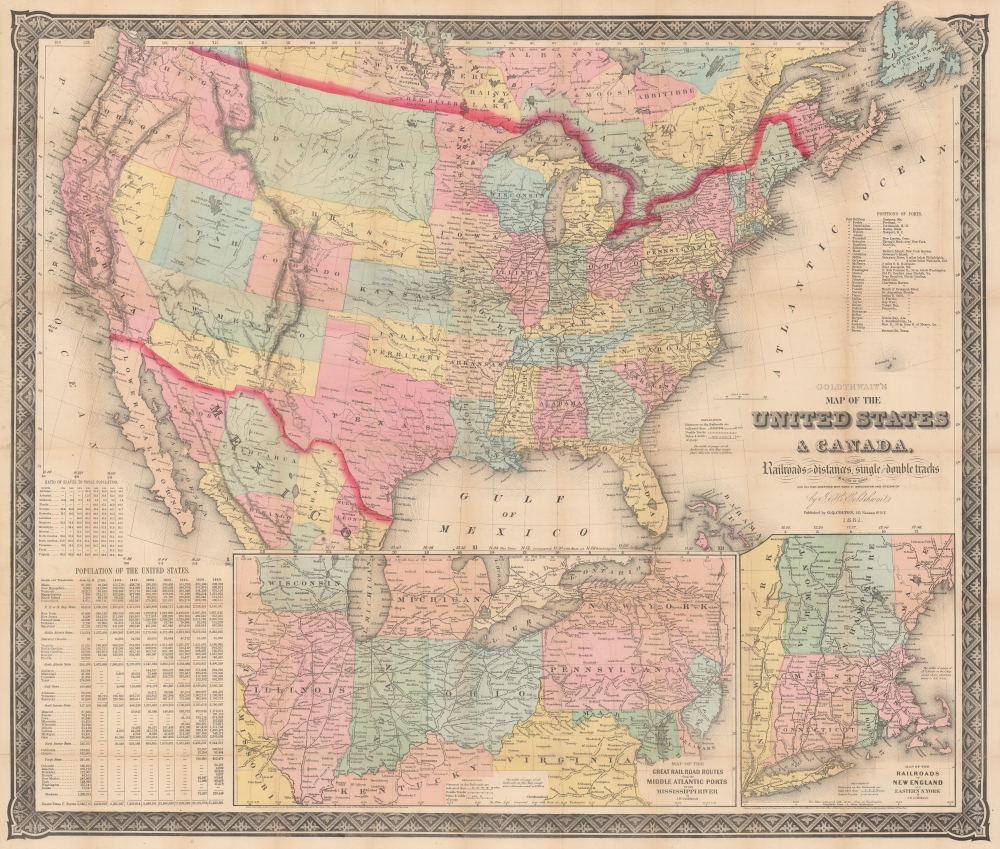
Goldthwait retains the prewar borders of Virginia and includes the Nevada, Dakota, and Colorado Territories, created just on the eve of the conflict. Notably, he divides the New Mexico territory in half, indicating the Confederate Arizona Territory (discussed below). The mapping of Canada is also unusual in that the territory of Rupert's Land is divided into territories named by local Native American groups, along with the Red River Colony.Railroads, waterways, and mountains (in the Western U.S. and Mexico) are indicated. Railroads are noted as being single or double-tracked and the width of their gauge is also recorded, all details of military importance. At right, a list of forts is provided with their locations. Inset maps at bottom focus on the railroads of New England and the Midwest. Tables at bottom-left list the population of the states and territories along with the ratio of slaves to free population through successive censuses. Local times across the county are compared with that in Washington, D.C. (time zones were not instituted until 1883).
Confederate Arizona
Confederate Arizona was a territory claimed by the Confederate States of America from 1861 until 1865. The idea for an Arizona Territory appears as early as 1856, when the government of the Territory of New Mexico began to express concerns about being able to effectively govern the southern part of the territory, as it was separated from Santa Fe by the Jornada del Muerto, a particularly unforgiving stretch of desert. The New Mexico territorial legislature acted on these concerns in February 1858, approving a resolution in favor of creating an Arizona Territory, with a north-south border to be defined along the 32nd meridian (from Washington). Impatiently waiting for Congress to approve the creation of the new territory, thirty-one delegates met at a convention in Tucson in April 1860 and drafted a constitution for the 'Territory of Arizona', which was to be organized out of the New Mexico Territory below the 34th parallel. The convention even elected a territorial governor and a delegate to Congress. Congress, however, was reluctant to act. Anti-slavery representatives knew that the proposed territory was located below the line of demarcation set forth by the Missouri Compromise for the creation of new slave and free states, and they were not inclined to create yet another slave state. Thus, Congress never ratified the proceedings of the Tucson convention, and the Provisional Territory was never considered a legal entity.At the beginning of the American Civil War (1861 - 1865), support for the Confederacy ran high in the southern parts of the New Mexico Territory. Local concerns drove this sentiment, including a belief that the war would lead to an insufficient number of Federal troops to protect the citizens from the Apache, while others simply felt neglected by Washington. Also, the Butterfield Overland Mail Route (an overland mail and stagecoach route from Memphis and St. Louis to San Francisco) was closed in 1861, depriving the people of Arizona of their connection to California and the East Coast.
All of these factors and others led to the people of the southern New Mexico Territory, or the Arizona Territory, to formally call for secession, and a convention adopted a secession ordinance on March 16, 1861, with a subsequent ordinance ratified on March 28, establishing the provisional territorial government of the Confederate 'Territory of Arizona'. The Confederate Arizona Territory was officially proclaimed on August 1, 1861, following Lieutenant-Colonel J. R. Baylor's victory over Union forces in the First Battle of Mesilla It was officially recognized by the government of the Confederacy on February 14, 1862. Nonetheless, by July 1862, Union forces from California known as the 'California Column' were marching on the territorial capital of Mesilla. Sent to protect California from a possible Confederate incursion, the 'California Column' drove Confederate forces out of the city, allowing them to retreat to Franklin, Texas. The territorial government fled as well and spent the rest of the war in 'exile'. First, they retreated to Franklin, then, after Confederate forces abandoned Franklin and all of West Texas, to San Antonio, where the 'government-in-exile' would spend the rest of the war. Confederate units from Arizona would fight for the rest of the war, and a delegate from Arizona attended both the First and Second Confederate Congresses.
Publication History and Census
This map was drawn by Jonathan Hale Goldthwait and published by 'G. Q. Colton' in New York in 1861. The identity of this little-known publisher is disputed. He might have been a member of the family of Joseph Hutchins Colton, whose firm was in a state of upheaval at this time, leading to a confusing mix of Colton publications from the early war period. But 'G. Q. Colton' is generally considered to be Gardner Quincy Colton, who briefly took up publishing before becoming a pioneer in the field of dentistry (a fuller biography is provided below). This map is held by the New York Public Library, Yale University, the Connecticut State Library, Brigham Young University, and the University of Texas at Arlington (which catalogs the publisher as G. Woolworth Colton, perhaps an alternate edition, but more likely a cataloging error).CartographerS
Jonathan Hale Goldthwait (May 21, 1811 - January 26, 1870) was an American engraver and publisher. Born in Longmeadow, Massachusetts, to Hannah and Erastus Goldthwait, he went to Boston to apprentice with a bank note engraver at the age of seventeen in 1828. He stayed in Boston until at least March 1834. He resurfaced in Springfield, Massachusetts, where he engraved a wall map of Springfield for his cousin George Colton (1793 - 1839). Charlotte Goldthwaite, in her genealogy of the Goldthwaite family, described Jonathan Hale Goldthwait as 'an artist in temperament, possessing a very intuitive sense of the beautiful and of the incongruous, and his fine taste and excellent judgment in such matters were very much sought and valued'. Another genealogy describes Goldthwait in this manner, 'He was a man of fine artistic temperament, a very expert copper-plate map engraver, and without an equal in the branches of small lettering and cutting 'rippled water', both as to rapidity and effect. He was also a good musician, and for many years played upon the organ in some leading church, where he was at the time residing.' Goldthwait married Susan Loud Joy on November 17, 1840, with whom he had three children. More by this mapmaker...
Gardner Quincy Colton (1814 - 1898) is best known as an innovator in the field of dentistry, namely for being an early and vocal proponent of the use of laughing gas (nitrous oxide) as an anesthetic. However, he led a much more colorful and variegated life than this simple fact might suggest. Born in Vermont, Colton initially worked odd jobs, including as a chairmaker, married and had one child, who sadly died at a young age. In 1842, he came to New York and studied with the renowned surgeon Willard Parker at the Crosby Street College of Physicians and Surgeons. During his medical studies, he became interested in the potential use of nitrous oxide as an anesthetic and began to travel the country giving demonstrations of its effects, administering the gas to members of the audience. As was common for the time, Colton was as much as showman as a medical man, and his audiences were enthralled by the amusing effects of the gas more so than its potential anesthetic properties. But he did attract the interest of some dentists and physicians, including Horace Wells, and Colton is credited with overseeing what may have been the first use of nitrous oxide as an anesthetic in a dental procedure, when one of Wells' teeth was extracted in 1844. In the following years, he pursued other scientific interests, including the telegraph (he befriended Samuel Morse) and electric motors (one of his models now sits in the Smithsonian). In 1849, he moved to California to join his brother Walter, a clergyman, publisher of California's first newspaper, The Californian, and the Alcade of Monterey, essentially the governor of California. G. Q. Colton sought a fortune in gold mining and in the process also became a justice of the peace in San Francisco, perhaps the first such office holder in California. In this capacity, he began selling lots in the city against the wishes of the town council, which opened legal proceedings against him. Whether undertaken due to a misunderstanding or deliberate skullduggery, Colton's land sales remained a sore issue in the city for years afterwards. For his part, Colton quickly returned to New York with a considerable sum of money, presumably from the land sales, and invested it all in a mining operation in Syracuse, which went bust. Around this time, he became a newspaper journalist and appears to have briefly moved into publishing, including lithographic prints and maps (he was a distant relative of Joseph Hutchins Colton, though it is unclear if this was his path into map publishing), which he looks to have given up in 1861 - 1862 (his autobiographical writings provide little information on this period). At this point, he returned to traveling the country to extol the virtues of nitrous oxide and in 1863 established an office at the Cooper Institute in New York. He eventually became known as the leading authority on the use of nitrous oxide in dental procedures in the city and administered the gas to thousands of patients. He later travelled internationally to further promote the procedure and died on one such trip while in Europe. Colton also dabbled in other fields and lectured widely on topics including chemistry, natural philosophy, and the analysis of Shakespeare from a Christian perspective. Learn More...


