
This item below is out of stock, but another example (left) is available. To view the available item, click "Details."
Details
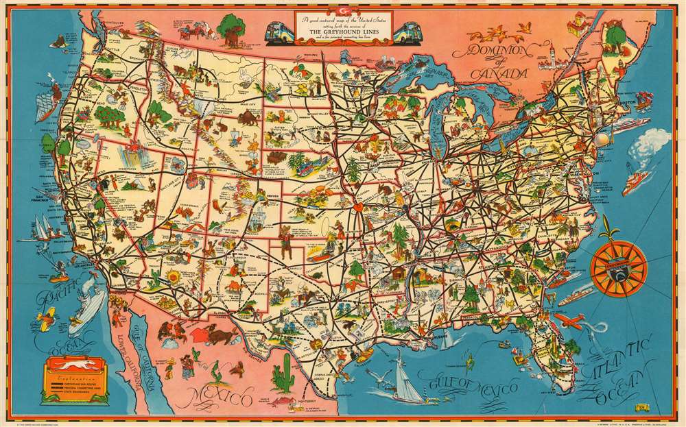
1939 Greyhound Pictorial Map of the United States
$200.00
1939 Greyhound Pictorial Map of the United States
UnitedStates-greyhound-1939$100.00

Title
A Good - Natured Map of the United States Setting Forth the Services of The Greyhound Lines and a Few Principal Connecting Bus Lines
1939 (undated) 11.25 x 18.5 in (28.575 x 46.99 cm)
1939 (undated) 11.25 x 18.5 in (28.575 x 46.99 cm)
Description
This is a charming 1939 pictorial map of the United States, produced as a pamphlet by the Greyhound Company to promote their line as a comfortable and affordable means of tourist travel - with a special focus on the upcoming New York World's Fair.
What 'Good Natured' Means in the 1930s
Like many of the most desirably pictorial maps, this one is filled with little cartoon vignettes meant to make humorous reference to the various regions depicted. Death Valley, for example, features a skeleton fanning itself and declaring 'Boy! Sure is hot!' A camel is shown near Alamagordo, New Mexico, saying 'Just like home!' In Reno, Nevada, we see a man, a woman, and a judge; the woman jauntily calling, 'So long, old dear, I'll be suing you.' (Reno, with a lenient residency requirement and accommodating courts, was famous as the divorce capital in the thirties and forties.)These jests are harmless enough, though the depictions of Native Americans, African Americans and Mexicans on the map frequently cross the line from 'Good Natured Humor' to 'Commentary on 20th Century American Racial Attitudes' and even approaching 'Wow! That's Racist.'An Updated Edition
The map's imagery is largely unchanged from the earlier issues, but it adds a stylized depiction of the architectural symbols of the 1939 fair, the Trylon and the Perisphere, replacing the previous depiction of the Statue of Liberty that previously appeared here.KD? KO?> Kappa Delta?
The author of this map is not known, in spite of it having been signed. In a banner in the lower right are the stylized initials KD (or KO, or the Greek letters Kappa Delta) but we have found no note in the admittedly sparse literature on these 20th century pictorials to indicate what these initials might stand for. OCLC shows a similar lack of success on the part of library cataloguers, who list 'Greyhound' and the 'Reserve Lithographing and Printing Company,' and call it a day.Publication History and Census
This 1939 small-format version of the map was printed by Cleveland's Reserve Lithographing & Printing Company, one of that city's many midcentury printing establishments. OCLC shows no other product from Reserve, apart from editions of this map and its larger progenitor. OCLC lists two examples only of the 1934 first issue of the full size map, and eight of the 1937 reissue. This 1939 issue, issued as a folding pamphlet, appears to have survived poorly: only two appear in OCLC, at the Biblio et Archives National de Quebec and the University of South Carolina.Condition
Very good condition. Original folds as issued. Else excellent with no mends or stains.
References
OCLC 44567187.