This item has been sold, but you can get on the Waitlist to be notified if another example becomes available, or purchase a digital scan.
1787 Le Rouge Map of the United States of America
UnitedStates-lerouge-1787$600.00

Title
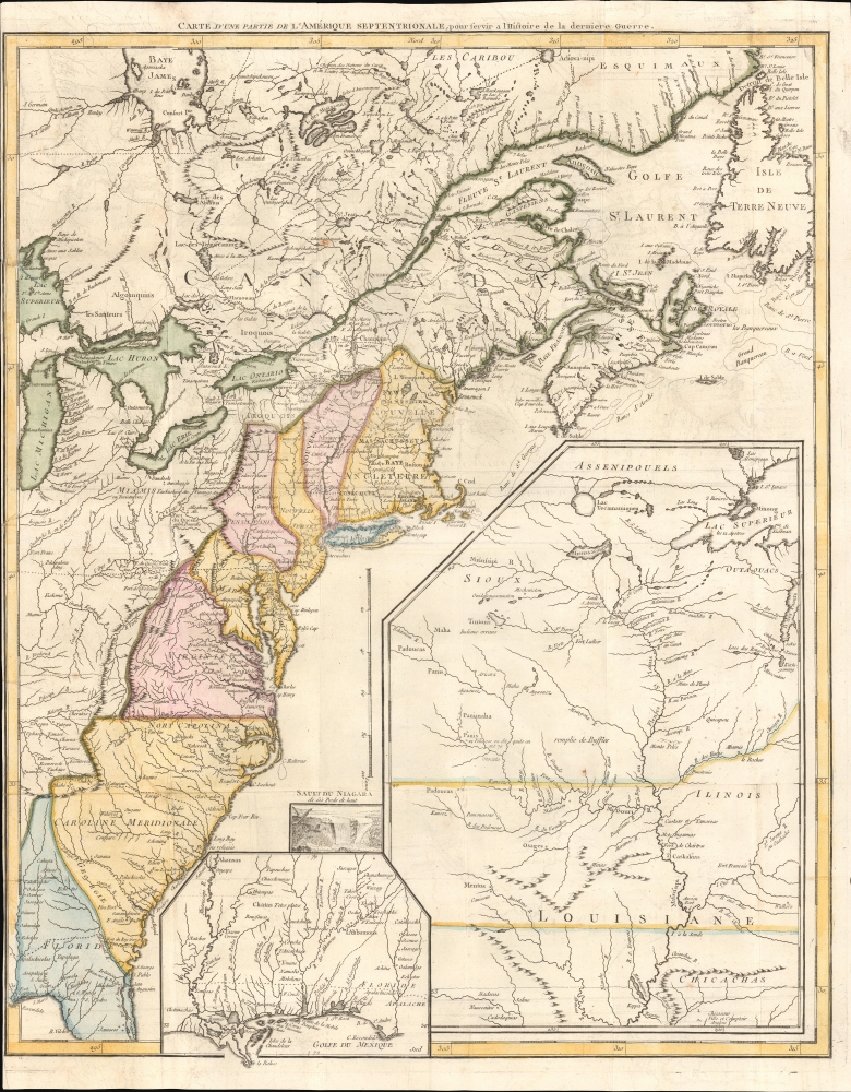
Carte d'une partie de l'Amérique Septentrionale, pour servir à l'histoire de la dernière guerre.
1787 (undated) 25 x 20 in (63.5 x 50.8 cm) 1 : 4500000
1787 (undated) 25 x 20 in (63.5 x 50.8 cm) 1 : 4500000
Description
An example of Louis Le Rouge's 1787 map of North America, prepared soon after the conclusion of the American Revolutionary War (1775 - 1783), making it among the earliest published maps of the new country. It is notable for some curious cartographic choices on the part of Le Rouge, as well as the inclusion of many Native American tribes and settlements on the American frontier.
Le Rouge employs curious borders, with New Jersey, New York, Pennsylvania, and Massachusetts extending far northwards into northern New England. New Hampshire is noted as such (not as Nouvelle Hampshire), and other Anglicized placenames such as 'Indian Town' and 'Nort Carolina' (rather than Caroline Septentrionale) give a hint at Le Rouge's sources (namely Jefferys' 1755 North America from the French of Mr. D'Anville… which incorporated British surveys to improve on d'Anville's existing work). In addition to the present map, Le Rouge had also prepared a much larger Amerique Septentrionale avec les Routes, Distances en miles, a French translation of the famous Mitchell Map (Map of the British and French dominions in North America etc., also offered by us, AmeriqueSept-lerougemitchell-1777). Thus, between d'Anville, Jefferys, Mitchell, Le Rouge, and others, we can see the dialogue between French and British cartography in the 18th-century mapping of North America.
Like New Hampshire, Connecticut and Rhode Island are labeled though not demarcated by their own borders, while Vermont is eschewed entirely, and the area around Lake Champlain is retained entirely by Quebec. (This omission might also be the result of Vermont's status as an unrecognized independent republic at the time). The colorist has made some interesting choices as well, shading Georgia and a small portion of Florida the same as the Carolinas but Long Island differently from New York. New York state is oddly divided in half by a border. Le Rouge himself acknowledges uncertainties, such as the differing location of 'Fort du Quesne' according to d'Anville and Jefferys, or a group of Native American villages on a branch of the Missouri River in the inset at right ('12 villages on dit quils en ont 70' - '12 villages they say there are 70').
In demarcating the borders of the new republic, Le Rouge is restrictive and more generous to the claims of Native American groups, cutting off Virginia, Pennsylvania, and other states at the Appalachian Mountains, far short of their claimed western boundaries (to say nothing of the westward claims of some colonies/states, such as Connecticut's Western Reserve, that theoretically extended all the way to the Mississippi River). This is unsurprising given the alliance between the French and many Native American groups on the frontier of British colonial America. Similar to William Faden's seminal map of the new American Republic (recently offered by us, UnitedStates-faden-1809), Le Rouge's presentation of the border is guided by both a desire for accuracy and an unspoken political agenda that would have been obvious enough to contemporary observers, with Le Rouge's original aim being to buttress French and allied Indian claims against the British during the French and Indian War, and Faden's goal being to undermine the westward expansion of the new American Republic.
A Closer Look
Covering the eastern coast of North America between Newfoundland and Florida, this map highlights the former British colonies whose independence as the United States of America had recently been confirmed. Settlements, forts, and Native American tribes are labeled throughout, as are rivers, lakes, mountains, and, on the ocean, sand banks. Three insets towards the bottom-right present Lower Louisiana (including much of today's Alabama and Mississippi), the Louisiana Territory writ large, and a small illustration of Niagara Falls. The locations of some battles of the French and Indian War (1754 - 1763) are referenced with crossed swords. Le Rouge adds some noteworthy descriptive text, such as 'remplie des buffles' (full of bison) just west of the Mississippi River in the inset at the bottom right.Le Rouge employs curious borders, with New Jersey, New York, Pennsylvania, and Massachusetts extending far northwards into northern New England. New Hampshire is noted as such (not as Nouvelle Hampshire), and other Anglicized placenames such as 'Indian Town' and 'Nort Carolina' (rather than Caroline Septentrionale) give a hint at Le Rouge's sources (namely Jefferys' 1755 North America from the French of Mr. D'Anville… which incorporated British surveys to improve on d'Anville's existing work). In addition to the present map, Le Rouge had also prepared a much larger Amerique Septentrionale avec les Routes, Distances en miles, a French translation of the famous Mitchell Map (Map of the British and French dominions in North America etc., also offered by us, AmeriqueSept-lerougemitchell-1777). Thus, between d'Anville, Jefferys, Mitchell, Le Rouge, and others, we can see the dialogue between French and British cartography in the 18th-century mapping of North America.
Like New Hampshire, Connecticut and Rhode Island are labeled though not demarcated by their own borders, while Vermont is eschewed entirely, and the area around Lake Champlain is retained entirely by Quebec. (This omission might also be the result of Vermont's status as an unrecognized independent republic at the time). The colorist has made some interesting choices as well, shading Georgia and a small portion of Florida the same as the Carolinas but Long Island differently from New York. New York state is oddly divided in half by a border. Le Rouge himself acknowledges uncertainties, such as the differing location of 'Fort du Quesne' according to d'Anville and Jefferys, or a group of Native American villages on a branch of the Missouri River in the inset at right ('12 villages on dit quils en ont 70' - '12 villages they say there are 70').
In demarcating the borders of the new republic, Le Rouge is restrictive and more generous to the claims of Native American groups, cutting off Virginia, Pennsylvania, and other states at the Appalachian Mountains, far short of their claimed western boundaries (to say nothing of the westward claims of some colonies/states, such as Connecticut's Western Reserve, that theoretically extended all the way to the Mississippi River). This is unsurprising given the alliance between the French and many Native American groups on the frontier of British colonial America. Similar to William Faden's seminal map of the new American Republic (recently offered by us, UnitedStates-faden-1809), Le Rouge's presentation of the border is guided by both a desire for accuracy and an unspoken political agenda that would have been obvious enough to contemporary observers, with Le Rouge's original aim being to buttress French and allied Indian claims against the British during the French and Indian War, and Faden's goal being to undermine the westward expansion of the new American Republic.
Publication History and Census
This map was prepared by George-Louis Le Rouge in 1787 for Francois Soules' Histoire des troubles de l'Amerique Anglais. It is the third iteration of the map, which Le Rouge first prepared in 1755, reflecting a French perspective on the territorial division of North America in the early days of the French and Indian War. It was then reworked soon after the start of the American Revolution and retitled Theatre de la Guerre en Amerique before being adapted again to the state seen here. This edition of the map is independently cataloged among the holdings of McGill University, the University of Michigan, the New York Public Library, and the University of Wisconsin-Milwaukee (in the latter two cases, attributed to the publisher of Soules' work, Brisson, in the catalog listing rather than Le Rouge).Cartographer
Georges-Louis Le Rouge (c. 1707 - c. 1790) was a Paris based map publisher operating in the middle part of the 18th century. Le Rouge was born in Hanover Germany as Georg Ludwig, where he was educated and employed as a military engineer and surveyor. His father may have been the French architect Louis Remy de la Fosse (1659 - 1726), which would explain his early education in both engineering and draftsmanship. He assisted his father on a large-scale plan of Darmstadt, which he completed following his father's death in 1726. He may have remained in Darmstadt, but little is known of his life from 1726 - 1736, when he appears in Paris. Le Rouge acquired a position as military and civil engineer for King Louis XV and Louis XVI. Around this time, he Francophied his name to 'Le Rouge'. In 1840, he set up shop on the Rue Des Grands Augustins as an engraver, book publisher, and map publisher. He partnered with the English cartographer and engineer John Rocque (1709 - 1762), who became an important source for English maps, which Le Rouge re-engraved for French use. Despite being born German and adopting Paris as his home, Le Rouge was an ardent Anglophile and spent much of his time translating English books and maps into French. During his active period of roughly forty years Le Rouge produced thousands of maps and diagrams ranging from city and town plans, to atlases, plans of military campaigns and sea charts. He was a friend and correspondent of Benjamin Franklin (1706 - 1790), with whom he produced the important 1769 Franklin/Folger Map of the Gulf Stream. Franklin, who met Le Rouge in Paris, writes that 'He [Le Rouge] is, I believe, a proper person.' He was awarded for his diligence with the impressive but unstipended honorific 'Geographe du Roi'. They may not have served him swell during the French Revolution (1789 - 1799), as his last known work was published in 1789, just before the storming of the Bastille. The exact date of Le Rouge's death remains a mystery. By most estimates, he is believed to have been alive in 1790, but may have lived as long as 1794. More by this mapmaker...
Source
Soulés, F., Histoire des troubles de l'Amerique Anglais, (Paris: Buisson) 1787.
Condition
Good. Creasing and some wear along fold lines and at intersections. Offsetting.
References
OCLC 49048122, 79091746, 425960254. McCorkle #755.23.