Digital Image: 1867 General Land Office Map of the United States w/ Mineral Deposits
UnitedStates2-landoffice-1867_d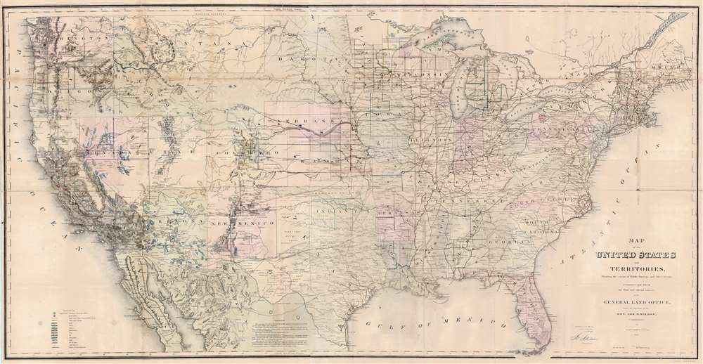

Title
Map of the United States and Territories, Showing the extent of Public Surveys and other details, Constructed from the Plats and official sources of the General Land Office.
1867 (dated) 28.75 x 56 in (73.025 x 142.24 cm) 1 : 3800000
1867 (dated) 28.75 x 56 in (73.025 x 142.24 cm) 1 : 3800000
Description
FOR THE ORIGINAL ANTIQUE MAP, WITH HISTORICAL ANALYSIS, CLICK HERE.
Digital Map Information
Geographicus maintains an archive of high-resolution rare map scans. We scan our maps at 300 DPI or higher, with newer images being 600 DPI, (either TIFF or JPEG, depending on when the scan was done) which is most cases in suitable for enlargement and printing.
Delivery
Once you purchase our digital scan service, you will receive a download link via email - usually within seconds. Digital orders are delivered as ZIP files, an industry standard file compression protocol that any computer should be able to unpack. Some of our files are very large, and can take some time to download. Most files are saved into your computer's 'Downloads' folder. All delivery is electronic. No physical product is shipped.
Credit and Scope of Use
You can use your digial image any way you want! Our digital images are unrestricted by copyright and can be used, modified, and published freely. The textual description that accompanies the original antique map is not included in the sale of digital images and remains protected by copyright. That said, we put significant care and effort into scanning and editing these maps, and we’d appreciate a credit when possible. Should you wish to credit us, please use the following credit line:
Courtesy of Geographicus Rare Antique Maps (http://www.geographicus.com).
How Large Can I Print?
In general, at 300 DPI, you should at least be able to double the size of the actual image, more so with our 600 DPI images. So, if the original was 10 x 12 inches, you can print at 20 x 24 inches, without quality loss. If your display requirements can accommodate some loss in image quality, you can make it even larger. That being said, no quality of scan will allow you to blow up at 10 x 12 inch map to wall size without significant quality loss. For more information, it is best consult a printer or reprographics specialist.
Refunds
If the high resolution image you ordered is unavailable, we will fully refund your purchase. Otherwise, digital images scans are a service, not a tangible product, and cannot be returned or refunded once the download link is used.
Cartographer S
The General Land Office (GLO) (1812 - 1946) was an independent agency of the United States government responsible for public domain lands in the United States. Created in 1812, it took over functions previously conducted by the Department of the Treasury. The GLO oversaw the surveying, platting, and sale of public lands in the western United States. It also administered the Preemption Act of 1841, which allowed individuals who were already living on federal land to purchase up to 160 acres of land before it was offered for sale to the general public, if they met certain requirements. Following the passage of the Homestead Act in 1862, which was also administered by the GLO, claims under the Preemption Act sharply decreased. The GLO became a part of the newly-created Department of the Interior in 1849. In 1891 Grover Cleveland and Congress created 17 forest reserves, due to public concern over forest conservation, which were initially managed by the GLO, until they were transferred to the Forest Service in 1905. In 1946 the Government Land Office was merged with the United States Grazing Service to become the Bureau of Land Management. Today the Bureau of Land Management administers the roughly 246 million acres of public land remaining under federal ownership. More by this mapmaker...
Joseph Shields Wilson (c. 1806 - June 23, 1874) was an Irish-American immigrant who held positions in the U.S. Department of the Treasury and the U.S. Department of the Interior. Born in Ireland, Wilson immigrated to the United States as a child and settled in Washington, D.C. He took a job as a messenger in the Department of the Treasury and was eventually promoted to a position as a Clerck. When the Department of the Interior was organized in 1849, Wilson was appointed Chief Clerk of the General Land Office. He served as the Commissioner of the General Land Office from 1860 to 1861 and again from 1866 to 1871. Wilson died in Washington, D.C. on June 23, 1874. Learn More...
John T. Bowen (b. c. 1801 - 1856) was a lithographer active in Philadelphia during the mid-19th century. Born in England, Bowen immigrated to the United States in 1834 and worked as a colorist and lithographer in New York City before moving to Philadelphia in 1838, most like with his collaborator and lithographic artist Alfred Hoffy. Once in Philadelphia, Bowen took over the business of Wild and Chevalier, located at 94 Walnut Street, and began publishing History of the Indian Tribes by McKenney and Hall. He also acquired the rights to Wild and Chevalier's series of views of Philadelphia, which he reissued at the end of 1838 and again in a hand colored edition in 1848. By the early 1840s, Bowen's work was garnering praise, and gained a reputation as one of the best lithographers in Philadelphia. He published the 'Architect's Digest' in 1839 and printed plates for Audubon's Quadrupeds (1845 - 1848) and the octavo edition of Birds of America (1839 - 1844). Despite numerous successes, Bowen field for bankruptcy in 1842, though it did not prove to be too much of a hindrance to his career, as, after 1844, he began working predominantly with Audubon and his sons on their works. Over the course of his career, Bowen became the preeminent Philadelphia lithographer and the most important mid-19th century American publisher of publication plates. By Bowen's death in 1856, he had a fairly substantial estate and a prosperous business. His wife, Lavinia, with whom he had a son, took over the business after her husband's passing and the firm Bowen and Company operated until around 1870. Learn More...
References
Library of Congress G3701.B5 1867 .U52. Boston Public Library, Leventhal Map Center, G3701.B5 1867 .U55. OCLC 11211281.