This copy is copyright protected.
Copyright © 2025 Geographicus Rare Antique Maps
Digital Image: 1752 Buache / Guettard 'First' Geological Map of the United States
UnitedStatesGeological-buache-1752_d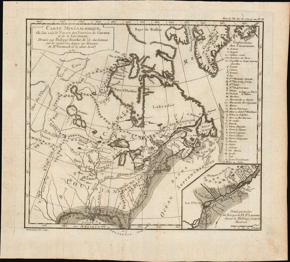

FOR THE ORIGINAL ANTIQUE MAP, WITH HISTORICAL ANALYSIS, CLICK HERE.
Digital Map Information
Geographicus maintains an archive of high-resolution rare map scans. We scan our maps at 300 DPI or higher, with newer images being 600 DPI, (either TIFF or JPEG, depending on when the scan was done) which is most cases in suitable for enlargement and printing.
Delivery
Once you purchase our digital scan service, you will receive a download link via email - usually within seconds. Digital orders are delivered as ZIP files, an industry standard file compression protocol that any computer should be able to unpack. Some of our files are very large, and can take some time to download. Most files are saved into your computer's 'Downloads' folder. All delivery is electronic. No physical product is shipped.
Credit and Scope of Use
You can use your digial image any way you want! Our digital images are unrestricted by copyright and can be used, modified, and published freely. The textual description that accompanies the original antique map is not included in the sale of digital images and remains protected by copyright. That said, we put significant care and effort into scanning and editing these maps, and we’d appreciate a credit when possible. Should you wish to credit us, please use the following credit line:
Courtesy of Geographicus Rare Antique Maps (http://www.geographicus.com).
How Large Can I Print?
In general, at 300 DPI, you should at least be able to double the size of the actual image, more so with our 600 DPI images. So, if the original was 10 x 12 inches, you can print at 20 x 24 inches, without quality loss. If your display requirements can accommodate some loss in image quality, you can make it even larger. That being said, no quality of scan will allow you to blow up at 10 x 12 inch map to wall size without significant quality loss. For more information, it is best consult a printer or reprographics specialist.
Refunds
If the high resolution image you ordered is unavailable, we will fully refund your purchase. Otherwise, digital images scans are a service, not a tangible product, and cannot be returned or refunded once the download link is used.
Phillipe Buache (February 7, 1700 - January 24, 1773) was a late 18th century French cartographer and map publisher. Buache began his cartographic career as the workshop assistant and apprentice to the important and prolific cartographer Guillaume de L'Isle. Upon De L'Isle's untimely death, Buache took over the publishing firm cementing the relationship by marrying De L'Isle's daughter. Over the years, Bauche republished many of De L'Isle's maps and charts. Buache was eventually appointed Premier Geographe du Roi, a position created-for and previously held by Guillaume de L'Isle. Buache is most respected for his introduction of hachuring as a method from displaying underwater elevation on a two dimensional map surface. Buache compiled maps based upon geographic knowledge, scholarly research, the journals of contemporary explorers and missionaries, and direct astronomical observation. Nevertheless, even in 18th century Paris geographical knowledge was severely limited - especially regarding those unexplored portions of the world, including the poles, the Pacific northwest of America, and the interior of Africa and South America. In these areas the Buache, like his primary rival Robert de Vaugondy, must be considered a speculative geographer or 'positive geographer'. Speculative geography was a genre of mapmaking that evolved in Europe, particularly Paris, in the middle to late 18th century. Cartographers in this genre would fill in unknown areas on their maps with speculations based upon their vast knowledge of cartography, personal geographical theories, and often dubious primary source material gathered by explorers and navigators. This approach, which attempted to use the known to validate the unknown, naturally engendered many rivalries. Buache's feuds with other cartographers, most specifically Didier Robert De Vaugondy, resulted in numerous conflicting papers being presented before the Academie des Sciences, of which both were members. The era of speculatively cartography effectively ended with the late 18th century explorations of Captain Cook, Jean Francois de Galaup de La Perouse, and George Vancouver. Buache was succeeded by his nephew Jean-Nicholas Buache de Neuville. More by this mapmaker...
François Desbruslins (1709 - 17xx) was a French map and line engraver active in Paris during the mid-18th century, from approximately 1719 until 1757. His is known for architectural plans, maps, and scientific diagrams. He engraved numerous maps for several famous French cartographers, including Philippe Buache and Jacques-Nicolas Bellin. Learn More...
Jean-Étienne Guettard (September 22, 1715 - January 7, 1786) was a French mineralogist, naturalist, and geologist active in Paris in the middle to late 18th century. Guettard was born in Étampes, near Paris. His maternal grandfather, François Descurain, an apothecary and doctor based in Étampes, encouraged him in the study of pants and medicines. He later became a medical doctor, but botany and geology remained his primary passion. From 1843, he was a member of the Paris Académie Royale des Sciences to which he submitted his first paper, to great acclaim, in 1746. In 1747, Guettard was offered the position of médecin botaniste to Louis, Duc d’Orléan. The sponsorship continued under the duke's son, Louis-Philippe, and Guettard received housing at the Palais-Royal. He was the first to survey and map the geologic features of France and to study the exposed bedrock of the Paris Basin. He was also produced the first geological maps of the United States (although he never visited) and Switzerland (which he did visit). As a scientist, he avoided making grand theories, instead, focusing on collecting and organizing data. Beyond science, was a devout Jansenist, a Catholic fringe sect that emphasized original sin, human depravity, the necessity of divine grace, and predestination. Guettard died in Paris in 1786. Learn More...
Copyright © 2025 Geographicus Rare Antique Maps | Geographicus Rare Antique Maps
This copy is copyright protected.
Copyright © 2025 Geographicus Rare Antique Maps