Digital Image: 1801 Bode Celestial Chart or Star Map of Ursa Major Constellation (Big Dipper) (elep
UrsaMajorLeoMinor-bode-1801_d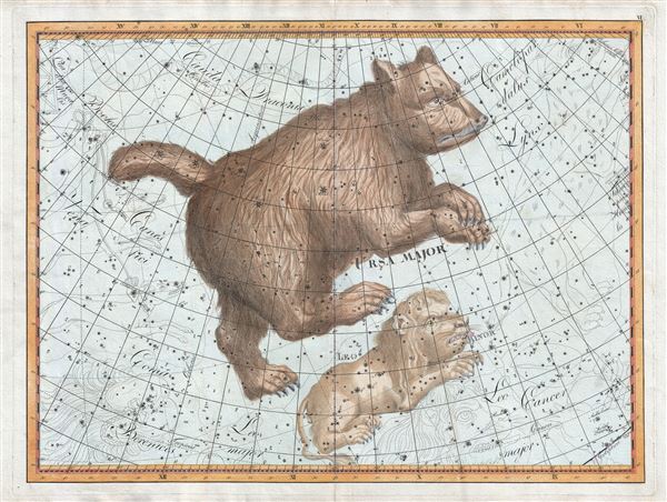

Title
Ursa Major.
1801 (undated) 24 x 34 in (60.96 x 86.36 cm)
1801 (undated) 24 x 34 in (60.96 x 86.36 cm)
Description
FOR THE ORIGINAL ANTIQUE MAP, WITH HISTORICAL ANALYSIS, CLICK HERE.
Digital Map Information
Geographicus maintains an archive of high-resolution rare map scans. We scan our maps at 300 DPI or higher, with newer images being 600 DPI, (either TIFF or JPEG, depending on when the scan was done) which is most cases in suitable for enlargement and printing.
Delivery
Once you purchase our digital scan service, you will receive a download link via email - usually within seconds. Digital orders are delivered as ZIP files, an industry standard file compression protocol that any computer should be able to unpack. Some of our files are very large, and can take some time to download. Most files are saved into your computer's 'Downloads' folder. All delivery is electronic. No physical product is shipped.
Credit and Scope of Use
You can use your digial image any way you want! Our digital images are unrestricted by copyright and can be used, modified, and published freely. The textual description that accompanies the original antique map is not included in the sale of digital images and remains protected by copyright. That said, we put significant care and effort into scanning and editing these maps, and we’d appreciate a credit when possible. Should you wish to credit us, please use the following credit line:
Courtesy of Geographicus Rare Antique Maps (http://www.geographicus.com).
How Large Can I Print?
In general, at 300 DPI, you should at least be able to double the size of the actual image, more so with our 600 DPI images. So, if the original was 10 x 12 inches, you can print at 20 x 24 inches, without quality loss. If your display requirements can accommodate some loss in image quality, you can make it even larger. That being said, no quality of scan will allow you to blow up at 10 x 12 inch map to wall size without significant quality loss. For more information, it is best consult a printer or reprographics specialist.
Refunds
If the high resolution image you ordered is unavailable, we will fully refund your purchase. Otherwise, digital images scans are a service, not a tangible product, and cannot be returned or refunded once the download link is used.
Cartographer
Johann Elert Bode (January 19, 1747 - November 23, 1826), or Joannis Elerti Bode, was a German astronomer active in Berlin during the late 18th and early 20th centuries. Bode was born in Hamburg and exhibited an early aptitude for mathematics, which brought him to the attention of Johann Georg Busch, whose library he was given access to. His interest turned towards astronomy early on and in 1766 he published his first work, a treatise on eclipses. He later published more treatises and issued an annual periodical called Astronomisches Jahrbuch, which enjoyed a 51 year run. In 1786 he became the director of the Berlin Observatory. During his tenure in this position he calculated the trajectory of Uranus, named the planet, and discovered the Galaxy M81, more commonly known as Bode's Galaxy. Bode is best known for his popularization of Bode’s law, or the Titius-Bode rule, an empirical mathematical expression for the relative mean distances between the Sun and its planets. However, in cartographic circles is best he is more admired for his 1801 publication of the Uranographia sive Astrorum Descriptio, a gigantic elephant folio atlas of the stars and the climax of an epoch of artistic representation of the constellations. Bode also published a smaller star atlas, the Vorstellung der Gestirne. Bode retired from professional life in 1825 and died in Berlin on year later. More by this mapmaker...
Source
Bode, J. E., Uranographia sive Astrorum Descriptio, (Berlin) 1801.
Bode's Uranographia sive Astrorum Descriptio is the largest and most elaborately produced celestial atlas of its period and possibly the greatest ever issued. The Uranographia follows in the tradition of Helvius, Flamstead, and Bayer, in which constellations are represented pictorially. However, in size and scope, Bode's work far outstrips his successors and may fairly be considered "the most extensive and last great atlas of its kind" (Warner). Bode's work, however, was no mere copy of that of his predecessors. The majestic size and scope of the Bode Uranographia is a natural response to his role as a serious scientist and his intention to update the traditional celestial atlas with the most up to date astronomical discoveries. Divided into 20 plates, the atlas catalogues 17,240 stars, all of which are illustrated according to their magnitude. He noted double stars, star clusters, nebulae, including the most recent discoveries by European astronomical luminaries like Lacaille, Lalande, Messier, and Herschel. More than 100 constellations are identified, even those that never caught on and may seem quite strange to use today. As such, it is the first reasonably complete atlas depiction of the starts visible to the unaided eye. The work was issued in Berlin, Germany in 1801. There is only one edition, but there were several printings. The Uranographia was immediately recognized as a masterpiece and while issued in black and white, many examples exhibit spectacular original color, with gold foiling or even gold dusting, courtesy of enthusiastic early owner. Today all examples of Bode's work are extremely rare.
References
Kanas, N., Star Maps: History, Artistry, and Cartography, 6.5.4, pages 183-4.