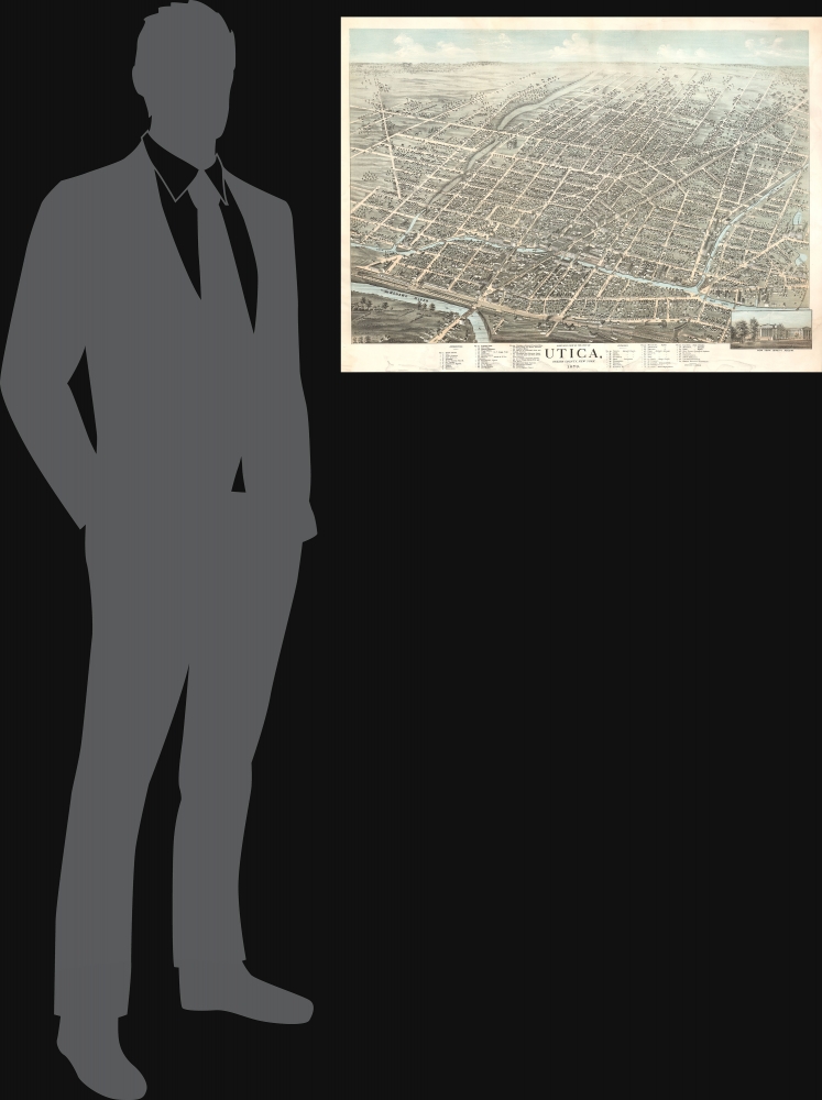
1873 Brosius Bird's-Eye View of Utica, New York
Utica-brosius-1873
Title
1873 (dated) 25 x 33.75 in (63.5 x 85.725 cm)
Description
A Closer Look
The view is presented from a high-oblique perspective, looking south at Utica. Genesee Street, the city's primary artery, runs diagonally across the view. At the center is a large formal park, now the site of Oneida Center for Rehabilitation and Nursing. The Mohawk River, Erie Canal, and several railway lines run prominently through town, emphasizing Utica's placement on major transportation networks.Historical Context
In the 1870s, Utica, New York, was a bustling industrial and transportation hub in the Mohawk Valley, benefiting from its strategic location along the Erie Canal and railroads. The city thrived on manufacturing, especially textiles, machinery, and furniture, while also serving as a gateway for immigrants, particularly Irish, German, and Italian workers, who provided labor for its factories and industries. Utica's population grew steadily, reflecting its economic vitality and role as a regional center of commerce and culture. The era also saw the rise of prominent institutions like banks, newspapers, and civic organizations, which contributed to its urban development. Despite challenges such as labor unrest and economic fluctuations common to industrial cities of the time, Utica's prosperity in the 1870s set the foundation for its continued growth into the late 19th century.American Bird's-Eye City Views
The Bird's-Eye view industry emerged in the United States in the middle part of the 19th century and coincided with the commercial development of lithographic printing. Before the rise of lithography, the ability to own and display artwork in the home was largely limited to the extremely wealthy, but the advent of lithographic printing made it possible for everyone to own visually striking artwork. A robust trade developed in portraits of political leaders, allegorical and religious images, and city views.City views were being produced in the United States as early as the 1830s, but the genre exploded after the American Civil War (1861 - 1865). Bridging the gap between maps and pictures, most 19th-century American bird's-eye views presented cities to the public from high points. Some were imagined, but others were drawn from hot-air balloons or nearby hills. The presentation, combining high elevation, commercial interest, and new printing technology, created a uniquely American art form, as described by historian Donald Karshan,
Some print connoisseurs believe that it was only with the advent of the full-blown city-view lithograph that American printmaking reached its first plateau of originality, making a historical contribution to the graphic arts. They cite the differences between the European city-view prints and the expansive American version that reflects a new land and a new attitude toward the land.The vogue for bird's-eye city views lasted from about 1845 to 1920, during which period some 2,400 cities were thus portrayed, some multiple times. Although views were produced in many urban centers, the nexus of view production in the United States was Milwaukee, Wisconsin. The major American viewmakers were Stoner, Wellge, Bailey, Fowler, Hill Ruger, Koch, Burleigh, Norris, and Morse, among others.
Chromolithography
Chromolithography, sometimes called oleography, is a color lithographic technique developed in the mid-19th century. The process uses multiple lithographic stones, one for each color, to yield a rich composite effect. Generally, a chromolithograph begins with a black basecoat upon which subsequent colors are layered. Some chromolithographs used 30 or more separate lithographic stones to achieve the desired effect. Chromolithograph color can be blended for even more dramatic results. The process became extremely popular in the late 19th and early 20th centuries when it emerged as the dominant method of color printing. The vivid color chromolithography made it exceptionally effective for advertising and propaganda.Publication History and Census
This view was drawn by Herman Brosius and published in 1873. We see no printer or publisher identified, but it may have been Brosius himself, or his twin brother, Frederick 'Fritz' Brosius, a prominent lithographer with the Milwaukee Lithographing and Engraving Company. We see just two examples in OCLC: one at the Library of Congress and the other at the University of Pennsylvania.Cartographer
Herman Brosius (April 8, 1851 - February 18, 1917) was a German-American bird's-eye view artist active in the late 19th century. Brosius was born in Milwaukee, Wisconsin, where he began his career as a wood carver for Matthews Brothers Furniture. His first bird's-eye views begin appearing around 1871, with his map of Darlington, Wisconsin. His corpus includes more than 60 maps, covering much of the United States, including cities in Louisiana, New York, Pennsylvania, Texas, and Virginia. His twin brother Frederick 'Fritz' Brosius (April 8, 1851 - September 30, 1909) was a prominent lithographer closely associated with Milwaukee Lithographing and Engraving (fl. c. 1872 - 1920), founded by Henry Seifart (1852 - 19??). Brosius died in Chicago in 1917. More by this mapmaker...


