Digital Image: 1867 Farrell View of the 'Meeting of the Waters', Vale of Avoca, Ireland
ValeofAvoca-farrell-1867_d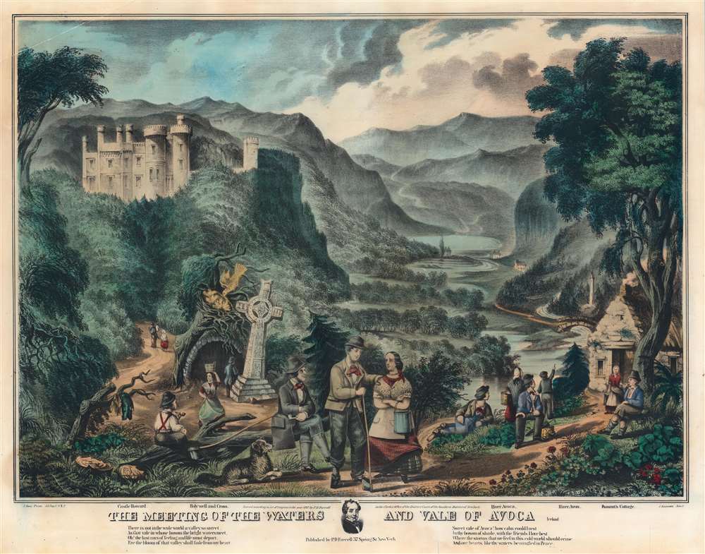

Title
The Meeting of the Waters and Vale of Avoca.
1867 (dated) 20.5 x 26 in (52.07 x 66.04 cm)
1867 (dated) 20.5 x 26 in (52.07 x 66.04 cm)
Description
FOR THE ORIGINAL ANTIQUE MAP, WITH HISTORICAL ANALYSIS, CLICK HERE.
Digital Map Information
Geographicus maintains an archive of high-resolution rare map scans. We scan our maps at 300 DPI or higher, with newer images being 600 DPI, (either TIFF or JPEG, depending on when the scan was done) which is most cases in suitable for enlargement and printing.
Delivery
Once you purchase our digital scan service, you will receive a download link via email - usually within seconds. Digital orders are delivered as ZIP files, an industry standard file compression protocol that any computer should be able to unpack. Some of our files are very large, and can take some time to download. Most files are saved into your computer's 'Downloads' folder. All delivery is electronic. No physical product is shipped.
Credit and Scope of Use
You can use your digial image any way you want! Our digital images are unrestricted by copyright and can be used, modified, and published freely. The textual description that accompanies the original antique map is not included in the sale of digital images and remains protected by copyright. That said, we put significant care and effort into scanning and editing these maps, and we’d appreciate a credit when possible. Should you wish to credit us, please use the following credit line:
Courtesy of Geographicus Rare Antique Maps (http://www.geographicus.com).
How Large Can I Print?
In general, at 300 DPI, you should at least be able to double the size of the actual image, more so with our 600 DPI images. So, if the original was 10 x 12 inches, you can print at 20 x 24 inches, without quality loss. If your display requirements can accommodate some loss in image quality, you can make it even larger. That being said, no quality of scan will allow you to blow up at 10 x 12 inch map to wall size without significant quality loss. For more information, it is best consult a printer or reprographics specialist.
Refunds
If the high resolution image you ordered is unavailable, we will fully refund your purchase. Otherwise, digital images scans are a service, not a tangible product, and cannot be returned or refunded once the download link is used.
Cartographer S
Peter D. Farrell (fl. 1860 - 1870) was an Irish-American lithographer, publisher, and subscription book publisher active in New York and Michigan in the mid-19th century. Farrell published under the imprint of 'P.D. Farrell Company'. In the late 19th century Farrell relocated to Copemish, Michigan and later, in 1900, to Grand Rapids, Michigan. Farrell published highly illustrated works focusing Ireland. More by this mapmaker...
Jacob Rau (1821 - ????) was a New York based engraver and lithographer who advertised himself as a 'practical lithographer.' He was born in Holstein, Germany and emigrated to New York between 1848 an 1850, likely fleeting repercussions from involvement in the Revolutions of 1848, making him a 48er. He maintained offices at 333 Broadway and later at 381 Pearl Street, where he published works in association with others from the German-American immigrant community, most prominent among them Gustav Kraetzer (1822 - 1901). Rau published maps, views, advertising, and books. He has some association with the Nicaraguan-German civil engineer Maximilian von Sonnenstern (1819 - 1895), also a 48er from Württemberg, for whom he published several seminal maps. From 1864 he was associated with Edward Valois, also a lithographer, with whom he published under the imprint of 'Valois and Rau.' His production seems to have stopped in the late 1860s. Learn More...
References
Library of Congress, 2003677595.