1838 S.D.U.K. City Map or Plan of Venice, Italy
Venice-sduk-1838$450.00

Title
Venice. Venezia. Venedig.
1838 (dated) 15.5 x 23 in (39.37 x 58.42 cm) 1 : 10800
1838 (dated) 15.5 x 23 in (39.37 x 58.42 cm) 1 : 10800
Description
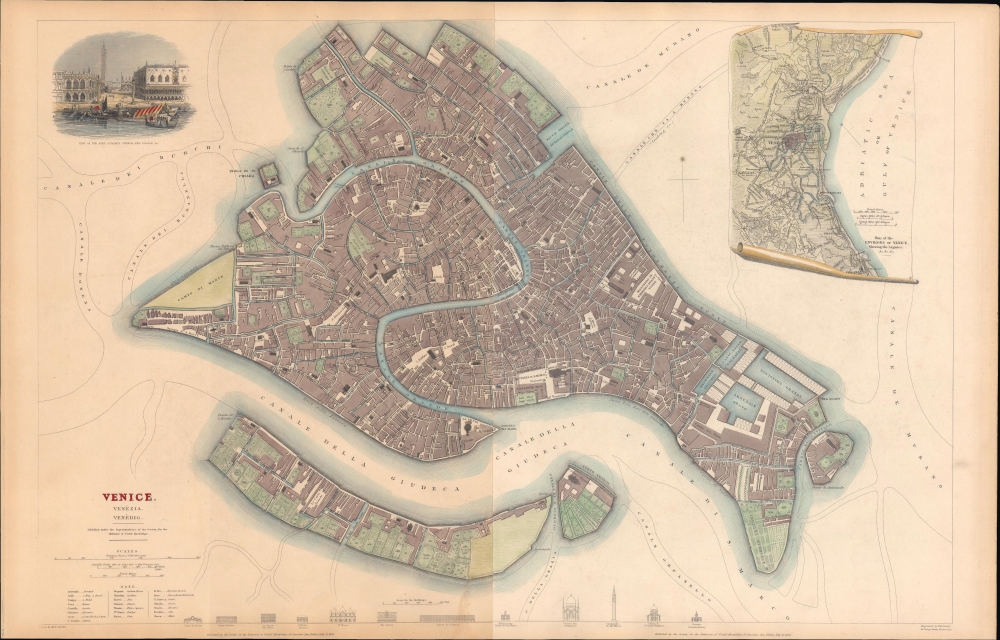
A hand-colored city plan or map of Venice, Italy, produced by the Society for the Diffusion of Useful Knowledge in 1838.
A legend at the bottom-left provides a guide for Italian terms utilized on the map. A series of profile views of prominent buildings in the city is included at the bottom, depicting the Ponte De La Rialto, the Piazza Rialto, la Zecca, the Prigioni, St. Mark's Basilica, the Palazzo Ducale, two buildings on the Piazza di San Marco (the longer being the Venice National Archaeological Museum), the Chiesa del Redentore, the Campanile di St. Marco, the Chiesa di S. Giorgio Maggiore, and the Dogana (Customs House).
A Closer Look
Coverage includes the main islands of Venice along with both internal and external canali, which are labeled along with roads, alleys, churches, piazze, and public institutions such as hospitals. The Jewish Ghetto is located towards the top ('ghetto nova'). St. Mark's Square (Piazza di S. Marco) appears at the center towards the bottom and is also illustrated in a view at the top-left. An inset map at the top-right displays the environs of Venice.A legend at the bottom-left provides a guide for Italian terms utilized on the map. A series of profile views of prominent buildings in the city is included at the bottom, depicting the Ponte De La Rialto, the Piazza Rialto, la Zecca, the Prigioni, St. Mark's Basilica, the Palazzo Ducale, two buildings on the Piazza di San Marco (the longer being the Venice National Archaeological Museum), the Chiesa del Redentore, the Campanile di St. Marco, the Chiesa di S. Giorgio Maggiore, and the Dogana (Customs House).
Rescuing Venetian Identity
This map was produced at a fraught moment in Venice's history. After having existed as a republic for over a millennium, the city was occupied by Napoleon's army and then placed under Austrian rule as part of a peace deal at the end of the War of the First Coalition (1792 - 1797). Austrian control of Venice was never solidly secured. The city was reconquered by Napoleon in 1805 before going back to Austria as the Kingdom of Lombardy-Venitia at the end of the Napoleonic Wars. Though the Austrian Empire was cosmopolitan and staffed the local bureaucracy with Italians, the arrangement was never popular and became less so as Italian nationalism grew throughout the 19th century. Resistance arose during the Revolutions of 1848 when a republic was briefly (re)established. Though that movement was crushed, the city was at the center of the Third Italian War of Independence in 1866, after which it joined the Kingdom of Italy.Publication History and Census
The map was drawn by William Barnard Clarke and engraved by Benjamin Reese Davies for Maps of the Society for the Diffusion of Useful Knowledge. Vol. 1, published by Chapman and Hall in 1844. It was originally published as two sheets but is joined here on a single sheet. The map is independently cataloged among the holdings of Princeton University, the University of Kentucky, the University of Illinois at Urbana-Champaign, and the University of Arizona, as well as the David Rumsey Historical Map Collection. The present example is especially attractive, including more complete hand coloring than other examples we have seen.CartographerS
The "Society for the Diffusion of Useful Knowledge" (1826 - 1848) was a Whiggish organization founded in 1828 at the instigation of idealistic British lord Henry Peter Brougham. The admirable goal of the Society was to distribute useful information via a series of publications to the English working and middle classes. It promoted self-education and the egalitarian sharing of all knowledge. While closely tied to the London University and publishing houses on the order of Baldwin and Cradock, Chapman and Hall, and Charles Knight, the Society failed to achieve its many lofty goals in finally closed its doors in 1848. Most likely the failure of the Society resulted from its publications being too expensive for its intended lower to middle class markets and yet not large and fine enough to appeal to the aristocratic market. Nonetheless, it did manage to publish several extraordinary atlases of impressive detail and sophistication. Their most prominent atlas consisted of some 200 separately issued maps initially published by Baldwin and Cradock and sold by subscription from 1829 to 1844. Afterwards, the Society combined the maps into a single world atlas published under the Chapman and Hall imprint. In its day, this atlas was unprecedented in its quality, scope, and cost effectiveness. Today Society, or S.D.U.K. as it is commonly known, maps are among the most impressive examples of mid-19th century English mass market cartographic publishing available. The S.D.U.K. is especially known for its beautiful and accurately detailed city plans. More by this mapmaker...
Benjamin Rees Davies (1789 - December 16, 1872) was an engraver, cartographer, painter, and map publisher active in the early to mid-19th century. Davies was born in Holborn, England, apprenticed as under John Lodge in 1803. He began publishing around 1811 and is known to have compiled many of own maps from original survey work. From approximately 1848 onward Davies published in conjunction with the Stanford Firm. He is also known to have engraved a number of maps for the Dispatch Atlas and the S.D.U.K. Davies was an early adopter of steel plate engraving and used the exceptional hardness of steel to create some of the most delicately engraved and beautifully produced maps of his era. He was quite famous in England for his detailed street plans of London, which he began publishing in 1848. Davies is known to have worked with numerous other cartographers of his period including French, Mexican, and American map makers. Many of his maps and plans continued to be published and updated posthumously well into the 1880s. Learn More...
William Barnard Clarke (1806 - 1865) was an English cartographer, architect, numismatist, literary translator, art collector, and archaeological writer. Born in Cheshunt, Hertfordshire, Clarke attended St. Paul's School in London beginning in 1817 at the age of 10. It is said that as a youth Clarke spent a substantial amount of time in Rome studying architecture and also spent time studying the ruins of Pompeii. He was also instrumental in founding the Architectural Society of London and was named President of the Society in 1831. As a cartographer, Clarke was an active member of the Society for the Diffusion of Useful Knowledge and created a Celestial Atlas for the Society as well as city plans of Dublin, Milan, Warsaw, Paris, and London among several others. Clarke married Charlotte Brooks at St. Andrew Holborn in London on July 1, 1830. Learn More...
Source
S. D. U. K, Maps of the Society for the Diffusion of Useful Knowledge, (London: Knight) 1842.
The Society for the Diffusion of Useful Knowledge (S.D.U.K.) Atlas was initially issued in parts over several years by Baldwin and Craddock to promote the society's mission of egalitarian self-education. The first S.D.U.K. began appearing in 1829 when the society contracted John Walker to produce the first proofs. The first S.D.U.K maps were produced serially by Baldwin and Craddock and issued in 2 map batches, priced at 2 shillings each. The series, originally anticipated to feature 50 maps, ultimately contained 200 and took over 14 years to produce. The initial production was completed in 1844 when the whole was issued in its first compiled atlas edition. Around 1842, following the 1837 bankruptcy of Baldwin and Craddock, publication of the atlas was taken over by the Society itself, who issued editions in 1838, 1839, 1840, 1841, and 1842. Overburdened by the work of publishing, they then outsourced the publication to Chapman and Hall in 1842. Chapman and Hall produced editions in 1842, 1843, and 1844. Dissatisfied with the quality of Chapman and Hall printing, the Society turned to another publisher, Charles Knight, who issued editions under the auspices of the Society in 1844, 1845, and 1846. In 1846 Knight officially acquired the plates in his own right and reissued in revised editions until 1852, when he sold them to George Cox. Cox in turn sold them to Edward Stanford who published them from 1856 well into the 1860s. The S.D.U.K. Atlas is known for the quantity and quality of its maps. The S.D.U.K. published many maps of areas largely ignored by other publishers. The many city plans incorporated into the atlas are particularly admired and are the highlight of the S.D.U.K.'s long map publishing history. As a whole the S.D.U.K. Atlas was groundbreaking in terms of quality, scope, and being offer at a cost effective price point.
Condition
Very good. Two sheets joined along centerfold. Light soiling.
References
Rumsey 0890.207. OCLC 35155232, 1398399037.