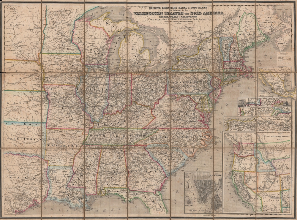
1866 Buchner'schen Buchhandlung Map of the United States of America
VereinigtenStaaten-buchnerschen-1866$1,300.00

Title
Neueste Eisenbahn-, Post- und Kanal- Karte für Reisende in den Vereinigten Staaten von Nord-Amerika, Canada, Texas, sowie Californien und den westlichen Staaten u. Gebieten.
1866 (undated) 21.5 x 29 in (54.61 x 73.66 cm) 1 : 3980000
1866 (undated) 21.5 x 29 in (54.61 x 73.66 cm) 1 : 3980000
Description
A scarce, hand-colored 1866 German language map of the United States, based on the work of Calvin Smith and Henry Tanner, published in Traugott Bromme's Hand- und Reisebuch für Auswanderer und Reisende nach Nord-, Mittel- und Süd-Amerika. It reflects continued interest in emigrating to the U.S., well after the surge of migration caused by the California Gold Rush and Revolutions of 1848 tapered off.
Six inset maps appear at bottom-right, highlighting the geography of Mexico, railroad lines between New York and Philadelphia, railroad lines between Philadelphia and Washington, D.C., railroads and canals in Upstate New York, states and territories in the western U.S., and a plan of New York City.
A Closer Look
The main map covers the eastern half of the United States, with individual states outlined in striking hand-color. Considerable detail is provided on cities, post roads, mountains, and waterways. Railroads existing and under construction are indicated, with the distances between cities noted in German geographic miles. Steamship lines in the Atlantic, Great Lakes, and on the Missouri and Mississippi Rivers are also illustrated. Washington, D.C. is employed as a Prime Meridian.Six inset maps appear at bottom-right, highlighting the geography of Mexico, railroad lines between New York and Philadelphia, railroad lines between Philadelphia and Washington, D.C., railroads and canals in Upstate New York, states and territories in the western U.S., and a plan of New York City.
Dating the Map
Though undated, the map appeared in an 1866 publication (see Publication History and Census below) and the borders reflect this date, as it includes the Montana Territory (established 1864), but lacks the Wyoming Territory (established 1868). The wide borders of the Utah Territory also support this date, as a slice of the western part of the territory was transferred to Nevada in May 1866.German Emigration to the U.S.
German emigration to the U.S. increased dramatically in the late 1840s, driven by both push and pull factors, with the California Gold Rush coinciding with the failed Revolutions of 1848 in Europe. The number of new German immigrants more than doubled in the 1850s relative to the 1840s, but the end of the Gold Rush did not end the migrations of German peoples to the U.S. Immigration remained robust for the following several decades, peaking in the 1880s.Publication History and Census
This map appeared in the 1866 edition of Traugott Bromme's Hand- und Reisebuch für Auswanderer und Reisende nach Nord-, Mittel- und Süd-Amerika (OCLC 6729500). It was drawn, engraved, and colored by Serz and Co. in Nuremberg, a family firm including Johann Georg (John) Serz, who himself emigrated to the U.S. The publisher is noted as the Buchner'schen Buchhandlung in Bamberg. Editions of maps with a similar title date back to the late 1840s and were issued regularly in the following years, with the present map being a late example. Due to the map's long title, multiple editions, and lack of a printed date, there is a proliferation of OCLC entries corresponding to it. However, based on the exact title used here, the present edition only looks to be independently cataloged by the Bayerische Staatsbibliothek (speculatively dated to 1871), while Yale University and Elizabethtown College hold a map dated to 1866 but with a slightly different title. The entire 1866 edition of Traugott's Hand- und Reisebuch für Auswanderer is well-represented in institutional collections.Source
Bromme, T., Traugott Bromme's Hand- und reisebuch für auswanderer und reisende nach Nord-, Mittel- und Süd Amerika, (Bamberg: Verlag der Buchner'schen Buchhandlung) 1866.
Condition
Very good. Dissected and laid on linen. Wear and loss in linen along fold lines and at intersections. Light foxing, especially at left-center and top-right.

