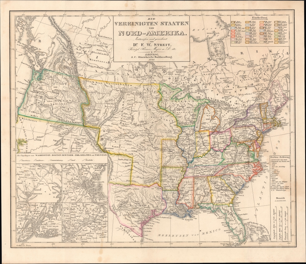
A scarce 1848 German-language map of the United States by Friedrich Wilhelm Streit, published by J.C. Hinrichs'sche Buchhandlung. It is notable, among other features, for its illustration of Texas as a republic and for its inclusion of ephemeral territorial borders in the central part of the United States.
A Closer Look
Taking in the United States, its territories, and parts of British North America (Canada) and Mexico, the map outlines states and territories in lovely hand coloring for easy differentiation. Though published after Texas' admission to the Union, it is maintained as an independent republic here, without its panhandle, 'stovepipe,' or enlarged western portion often seen in contemporary maps, representing the largest claims of the republic cum state.
A large unincorporated territory occupies what is now the Plains States, with Native American groups listed in considerable detail. Railways, roads, canals, cities, forts, Native American groups and settlements, and topographic features are indicated throughout, according to the legend at the bottom right. At the top-right is another legend explaining the color outlines that differentiate states. At bottom-left are inset maps of the cities of Washington, D.C., Boston, New York, and Philadelphia (with Trenton).
The territory soon to become the Western United States maintains several cartographic myths (such as the Buenaventura River) and does not reflect the discoveries of the Frémont expeditions earlier in the decade. Although some settlements in Alta California are noted (including San Francisco), details are fairly limited, suggesting publication before widespread news of the gold discovered there had reached the mapmakers.The Mainzer Adelsverein - A German Colony in Texas
The German colony highlighted in Texas was officially called the Mainzer Adelsverein at Biebrich am Rhein. Founded on April 20, 1842, the society attempted to establish a German colony within the Republic of Texas. The land where the immigrants intended to live was to be purchased by the Adelsverein or granted to them by the Republic of Texas. The first colonists associated with the Adelsverein arrived in Galveston in July 1844. In December 1844, the immigrants moved to Indianola and then farther inland to grants near Comal Springs. The first colony was New Braunfels, named by Prince Carl of Solms-Braunfels (the first commissioner general of the Adelsverein) after his homeland. The second commissioner-general, John O. Meusebach, founded Fredericksburg in 1845, the first settlement outside the land grant, here as 'Deutsche Colonie des Mainzer Ver.' (a nearby French colony is also noted, near San Antonio, the result of efforts by French impresario Henri Castro). The Adelsverein ended its campaign to colonize Texas in 1853 due to a large amount of debt. Nonetheless, during this period, Texas built a significant German population, and New Braunfels retains its German heritage.Publication History and Census
This map was originally prepared by Friedrich Wilhelm Streit and published by J. C. Hinrichs'sche Buchhandlung. In both institutional collections and sales in recent years, we note editions from 1841, 1842, 1844, and 1851, in addition to the present 1848 edition, presumably derived from a map prepared by Streit before he died in 1839, which has since disappeared. Regardless of edition, the map is quite rare, with the present edition only noted among the institutional holdings of the University of Texas at Arlington.
CartographerS
Friedrich Wilhelm Streit (January 29, 1772 - June 12, 1839) was a Prussian military officer, engineer, mathematician, and cartographer. Streit began his career as an artillery officer in the Prussian military, where he honed his mathematical and cartographic skills. After leaving military service at the rank of major, he became a member of the Akademie gemeinnütziger Wissenschaften zu Erfurt and Gesellschaft für Erdkunde, one of the leading Prussian geographical bodies of the day. From 1807 to 1817 he was director of the map department of the Geographisches Institut Weimar. Over the same period, he oversaw the 'Topographisch-militairische Charte von Teutschland,' an ambitious project to survey the entirety of Central Europe on a consistent medium scale (1:180000), resulting in over 200 maps and supplements. He also published textbooks on mathematics and an English-German dictionary. More by this mapmaker...
Johann Conrad Hinrichs (October 30, 1763 - September 22, 1813) was a German publisher and bookseller. Little is known of his early life. In 1796, Hinrichs became partners with August Leberecht Reinicke, who had founded a bookstore in Leipzig five years earlier. By 1801, Hinrichs ran the bookstore alone. Beginning in 1798, he published catalogs of all new published works in the past six months, an invaluable resource for the reading public. Hinrichs then moved into publishing books in the fields of travel literature, law, political science, and history. After his death, his business was run by his widow Christiane Wilhelmine Hinrichs, a sister of Reinicke, initially alone and from 1816 together with her nephew Christian Friedrich Adolf Rost, who became a partner in 1819, with the business publishing as 'J.C. Hinrichs'sche Buchhandlung.' It took on specialties in theology and Oriental Studies and survived into the 20th century. Learn More...
Very good. Light wear along centerfold. Light soiling.
OCLC 694516923.