This item has been sold, but you can get on the Waitlist to be notified if another example becomes available, or purchase a digital scan.
1821 Whitelaw Wall Map of Vermont
Vermont-whitelaw-1821$900.00

Title
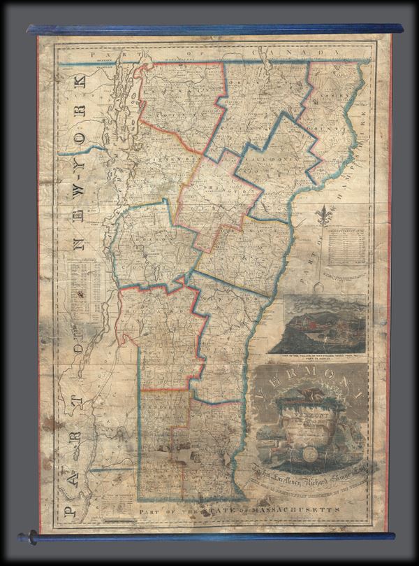
Vermont from Actual Survey with all the Late Additions and Improvements.
1821 (dated) 47 x 32.5 in (119.38 x 82.55 cm) 1 : 237600
1821 (dated) 47 x 32.5 in (119.38 x 82.55 cm) 1 : 237600
Description
This is a large 1821 wall map of Vermont by James Whitelaw, Esq. It covers the state of Vermont in its entirety along with parts of its neighboring states. The map notes Rivers, roads, mountains and a host of additional topographical features. Also notes, meetinghouses, courthouses, grammar schools, mills, iron works, ferries, forts, etc., with a key to their locations in the lower left quadrant. County lines are marked in outline color. A table near the left border notes the population of the States of the Union in 1810 and 1820. Another table near the right border notes the population by county in Vermont for 1820. Identifies Killington Peak, now a popular ski resort. A large title cartouche adorns the lower right quadrant of the map and includes the state seal. A 'View of the village of Montpelier taken from Mill Point in Berlin,' illustrated by Mrs. S. I. Watrous appears above the title cartouche.
In 1790, the newly independent United States needed accurate maps for defense and commercial purposes, but could not afford to undertake the mammoth task of mapping the entire country. Individual states took up the project, pioneered by the state of Vermont under Surveyor General James Whitelaw, originally a Scottish Surveyor who came to America in 1773. In 1796, Whitelaw published the first Correct Map of the State of Vermont. His map proved to be far more accurate than previous attempts by cartographers like Jefferys and Blodgett and would go on to be revised and reissued for the next 50 years. This particular map is one such example. This map based on his wall map of 1796, was issued in 1821 by James Whitelaw, Esq., Late Surveyor General to his Excellency Richard Skinner, Esq. (Governor of Vermont from 1820-1823), and is respectfully dedicated by the publisher Ebenezer Hutchinson.
In 1790, the newly independent United States needed accurate maps for defense and commercial purposes, but could not afford to undertake the mammoth task of mapping the entire country. Individual states took up the project, pioneered by the state of Vermont under Surveyor General James Whitelaw, originally a Scottish Surveyor who came to America in 1773. In 1796, Whitelaw published the first Correct Map of the State of Vermont. His map proved to be far more accurate than previous attempts by cartographers like Jefferys and Blodgett and would go on to be revised and reissued for the next 50 years. This particular map is one such example. This map based on his wall map of 1796, was issued in 1821 by James Whitelaw, Esq., Late Surveyor General to his Excellency Richard Skinner, Esq. (Governor of Vermont from 1820-1823), and is respectfully dedicated by the publisher Ebenezer Hutchinson.
Condition
Good. Full professional restoration and stabilization. Cleaned and rebacked with modern linen and new edging. Overall toning and cracking. Minor portions of the map missing in the lower quadrants, especially over Windham and Bennington Counties. Some staining and mold damage.