This is a rare 1961 Jihel pictorial map of France's wine regions.
A Closer Look
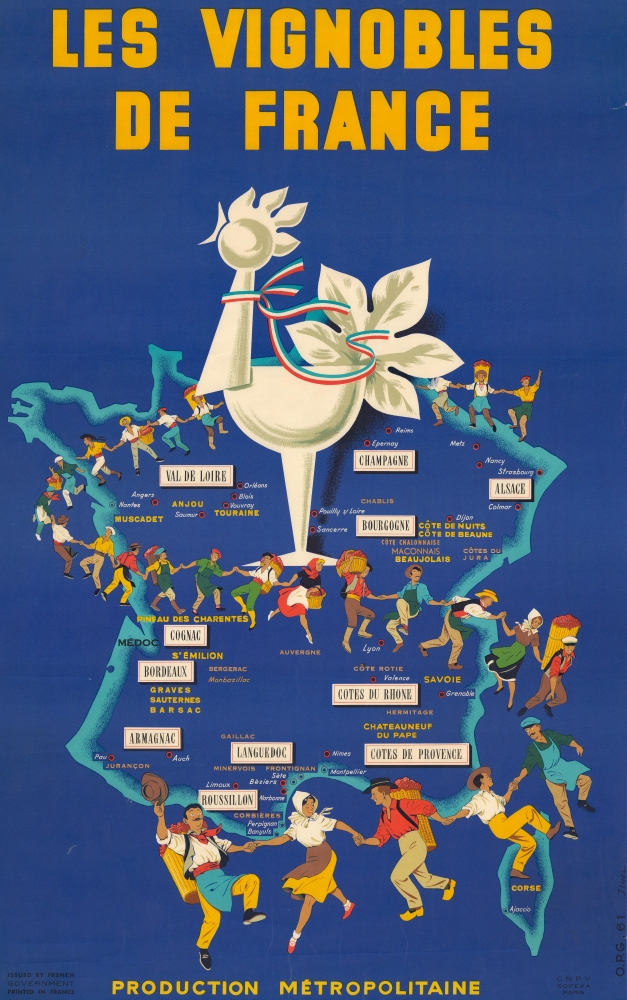
The bold graphic features a large map of France over which superimposed a powerful rooster and a chain of hand-holding wine producers dancing across the countryside. Major wine-producing regions are highlighted, including Champagne, Bordeaux, Cotes du Rhone, Bourgogne, Alsace, and the Val de Loire, Graves, Sauternes, Beaujolais, Côte de Nuits, and Côte de Beaune, Minervois, and Frontignan. Cognac and Armagnac are also noted. Major cities named include Montpelier, Lyon, Grenoble, Dijon, Metz, Orléans, and Angers. The French cockerel, wearing a tricolor ribbon, dominates the upper portion of the sheet.Rooster
The central figure on this map, a large crowing rooster, is a significant symbol in both France and in French wine. The 'coq gaulois,' as it is known, symbolizes heritage, resilience, and spirit. This rooster has been associated with France since ancient times, as the Latin word for rooster, 'gallus,' also means Gaul, the ancient region that corresponds largely with modern France. The rooster is particularly associated with the 'Label Rouge' certification and the 'Vin de Pays d'Oc' wines. Its association with wine connotes quality and authenticity, highlighting adherence to traditional rigorous production standards. The rooster often represents wines that are deeply rooted in French heritage and terroir, reflecting a commitment to superior agricultural practices and regional identity.Publication History and Census
This map was created by Jihel and published by the French government in 1961. This piece is rare. We are aware of 2 examples in private collections, and no examples appear in OCLC.
Cartographer
Jacques Camille Lardie (b. June 26, 1947) is a French photographer, lithographer, editorial cartoonist, investigative journalist, caricaturist, and sculptor. Born in Périgueux, Lardie, known by several pseudonyms, the most prominent of which is 'Jihel', is known for creating posters, postcards, and political cartoons. Many of his postcards feature photographic portraits of famous people, including French and British politicians. Lardie founded to publishing houses, Êditions du Triangle and Éditions de la canetille. He is also known for several series of cards, which are focused on the Mona Lisa, absinthe, and freemasonry, respectively. Many of his sets of postcards are limited edition of 100 examples of each card. More by this mapmaker...
Very good. Minor closed edge tears stabilized on verso. Slight loss along right edge.