1910 Eldridge Chart of Vineyard Sound: Martha's Vineyard, Nantucket
VineyardSound-eldridge-1910$2,500.00


Title
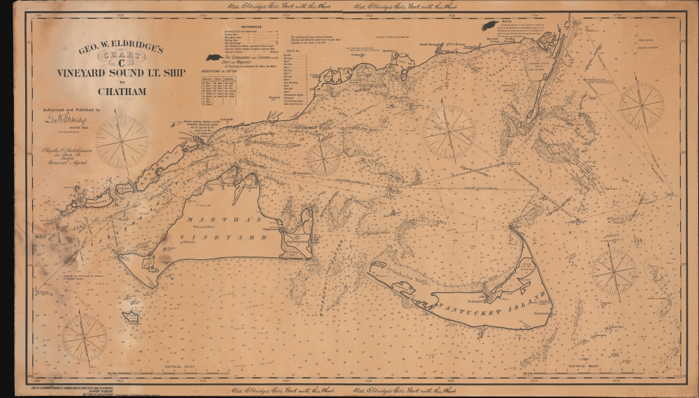
Geo. W. Eldridge's Chart C Vineyard Sound Lt. Ship to Chatham.
1910 (dated) 28.25 x 49.75 in (71.755 x 126.365 cm) 1 : 80000
1910 (dated) 28.25 x 49.75 in (71.755 x 126.365 cm) 1 : 80000
Description
This is George W. Eldridge's 1910 nautical map of Vineyard Sound, including Martha's Vineyard and Nantucket Island.
A Closer Look
Coverage follows the Lower and Mid Cape from Wood's Hole to Chatham, along with the Elizabeth Islands, and extends south to include both Martha's Vineyard and Nantucket. The map is rich with hydrographic detail vital to navigators plying these infamously problematic seas, including currents, soundings, shows and riptides, the locations of lightships, and more. The legend locates 13 different types of buoys. It also notes fishing grounds.Historical Context
By 1910, Martha's Vineyard and Nantucket's famed whaling industry had vanished, but both islands continued to support large fishing fleets. The islands nonetheless continued to prosper as picturesque summer resorts for the affluent, particularly Edgartown, Oak Bluffs, and Vineyard Haven. The island economies were driven by tourism, agriculture, and fishing, reflecting a blend of old New England traditions and the burgeoning hospitality industry. Nantucket, smaller and more isolated, retained much of its historic character, with its cobblestone streets, well-preserved whaling captain's homes, and serene landscapes. Both islands were accessible primarily by ferry, and their relatively untouched natural beauty and sense of seclusion made them attractive to artists, writers, and those in search of a peaceful escape from the urban hustle and bustle.Publication History and Census
This is not the Eldridge firm's first map of Martha's Vineyard and Nantucket, but it is the first edition thus, part of the general update to the elder Eldridge's work compiled by his son, George Washington Eldridge.. This map was first drawn in 1910, replacing his earlier chart with new engraving, broader covering, and significantly updated content. The present example also bears the imprint of Charles C. Hutchinson, Eldridge's sales agent in Boston. This chart was popular and was reissued with regular updates until about 1928. However, first-edition examples are rare. OCLC cites only one example, located at the Boston Athenaeum. We note an additional holding at the Boston Public Library.Cartographer
George Eldridge (November 27, 1821 - August 23, 1900) and his son George Washington Eldridge (1845 - 1914) were American makers of nautical charts and Pilot Books active in the late 19th century. George Eldridge was a Cape Cod fisherman known locally as an excellent ship's pilot. While recuperating from an injury in 1851, Eldridge drew his first nautical chart. The chart proved popular, and its success led Eldridge to pursue a career in hydrography - the science of mapping the sea with a special focus on navigation. Eldridge produced numerous subsequent maps and is credited with issuing some of the earliest accurate nautical charts of the American Atlantic coast. In time George Eldridge passed his thriving business on to his son, George Washington Eldridge, who continued to produce beautiful and practical maritime charts until 1924.Though most of Eldridge's charts were loosely based on U.S. Coast Survey work, they proved popular with navigators. The Eldridges possessed a talent, shared by both father and son, for distilling the often convoluted Coast Survey maps into practical nautical charts for the working mariner. From 1875, in addition to large format independently issued nautical charts, Eldridge also issued annual editions of Eldridge's Tide and Pilot Book and The Book of Harbor Charts. The Eldridge offices were located at 103 State St. Boston, Massachusetts. After the deaths of George and George Washington Eldridge, the firm passed into the hands of the latter's widow Sydna, and son-in-law, Wilfrid O. Wight. Wight's son and subsequent generations have continued to publish the Eldridge Tide and Pilot Book down to the present. More by this mapmaker...
Condition
Good. Sailed. Laid down on original linen. Some staining associated with shipboard use along the left side. Even overall toning.
References
OCLC 954156027. Guthorn, P., United States Coastal Charts, 1783-1861, p. 12. Boston Public Library, G3762.V5P3 1910 .E43.