1972 Polish Multilingual Map of Poland and Battles Against the Nazis During WWII
WalkiZbrojne-ochronypomnikov-1972$4,000.00


Title
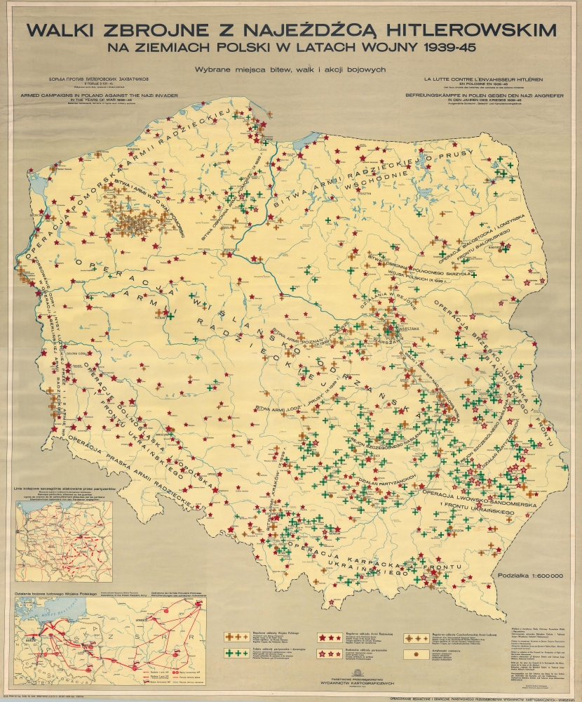
Walki Zbrojne z Najeźdźcą Hitlerowskim na Ziemiach Polski w Latach Wojny 1939 - 45. / Armed Campaigns in Poland Against the Nazi Invader in the Years of War 1939 - 1945.
1972 (dated) 56.5 x 46.5 in (143.51 x 118.11 cm) 1 : 600000
1972 (dated) 56.5 x 46.5 in (143.51 x 118.11 cm) 1 : 600000
Description
This is a 1972 Polish multilingual educational wall map of Poland chronicling the resistance to the World War II Nazi invasion. The map lionizes Polish and Red Army accomplishments in resisting the Nazi plague but, as a product of the Eastern Bloc, conveniently ignores the 1939 Sovient Invasion and related atrocities.
This derives from the necessity of kowtowing to Soviet censorship. Although the Nazis and Hitler are demonized, there is no clear anti-German bias. The map appears to have been produced from impartial sources to represent Nazi war crimes accurately. Through this and similar maps, much of the current leadership of Poland, who grew up in the Soviet Era, received their education and understanding of the Holocaust.
Today, historical revisionism regarding Poland's role in the Holocaust encompasses a contentious area of public discourse. The narrative traditionally highlights Poland as a nation under German occupation, with Poles risking their lives to help Jews. This happened. However, current scholars are bringing to light instances where some Poles collaborated with Nazis or participated in the persecution of Jews. This revisionism has sparked intense debate, influenced by broader considerations of national identity, memory, and responsibility. Current efforts by the Polish government to legislate how the Holocaust is remembered, particularly laws making it illegal to accuse the Polish nation of complicity in the Holocaust, have further intensified these debates, highlighting the ongoing struggle over the historical record.
A Closer Look
Symbols that mark actions by armed groups fighting the Nazis appear below the map at the center and are explained in Polish, Russian, English, French, and German. The Polish forces are identified first, with yellow crosses marking regular troops of the Polish Army and green crosses identifying Polish guerrilla and diversion troops. Red stars mark regular troops of the Soviet Army, while red and white start mark Soviet guerrillas. Yellow crosses with crossed swords mark actions taken by the regular troops of the Czechoslovak People's Republic's Army, and yellow circles identify German anti-fascists. The large block text on the map identifies campaigns and battles fought by the Polish and Soviet armies. Battles fought by the Polish Army in September 1939 are highlighted, the participants named, and the action dated 'IX 1939 r'. None of the battles fought against the Soviets in 1939 appear. Two insets in the bottom left illustrate railways attacked by guerrillas and operations of the Polish People's Army.Through a Soviet Lens
When this map was issued, Poland was firmly part of the Soviet Eastern Bloc. While the map is sensitive to the plight of Poles in general and especially the Soviets who suffered under the Nazis, this map is representative of the Soviet party line regarding 'Hitler's atrocities' - that all nations suffered, fought, and won equally. Aside from the Soviets and Poles, there is no mention of any specific ethnic or religious group. There also is naturally no mention of the Soviet Union's repressive actions and war crimes against Poles.This derives from the necessity of kowtowing to Soviet censorship. Although the Nazis and Hitler are demonized, there is no clear anti-German bias. The map appears to have been produced from impartial sources to represent Nazi war crimes accurately. Through this and similar maps, much of the current leadership of Poland, who grew up in the Soviet Era, received their education and understanding of the Holocaust.
Today, historical revisionism regarding Poland's role in the Holocaust encompasses a contentious area of public discourse. The narrative traditionally highlights Poland as a nation under German occupation, with Poles risking their lives to help Jews. This happened. However, current scholars are bringing to light instances where some Poles collaborated with Nazis or participated in the persecution of Jews. This revisionism has sparked intense debate, influenced by broader considerations of national identity, memory, and responsibility. Current efforts by the Polish government to legislate how the Holocaust is remembered, particularly laws making it illegal to accuse the Polish nation of complicity in the Holocaust, have further intensified these debates, highlighting the ongoing struggle over the historical record.
Publication History and Census
This map was edited by Barbara Filochowska and Jerzy Kosmowski for the Rady Ochrony Pomników Walki I Męczeństwa (Council for the Protection of Fight and Martyrdom Monuments) and published in 1972 by the Państwowe Przedsiębiorstwo Wydawnictw Kartograficznych (National Cartographic Publishing Company). Cataloged examples are located at the Centralna Biblioteka Wojskowa (Central Military Library and the Herder-Institut) and the National Library of Poland.Condition
Very good. Mounted on linen. Some crinkling and creasing. Close top and bottom margin.
References
Centralna Biblioteka Wojskowa MDZS DZS C-III-654. Herder-Institut S 34589. OCLC 956616735.