This copy is copyright protected.
Copyright © 2025 Geographicus Rare Antique Maps
Digital Image: 1864 'Home Insurance' Civil War Map of the Washington - Richmond Area
WashingtonRichmond-heald-1864_d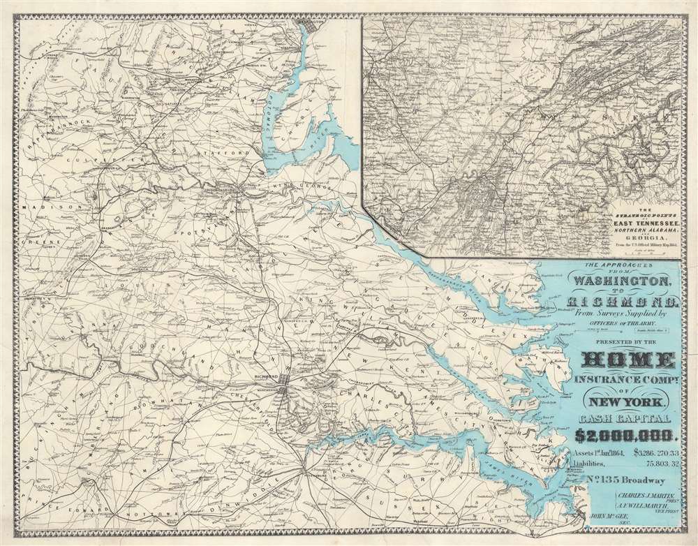

FOR THE ORIGINAL ANTIQUE MAP, WITH HISTORICAL ANALYSIS, CLICK HERE.
Digital Map Information
Geographicus maintains an archive of high-resolution rare map scans. We scan our maps at 300 DPI or higher, with newer images being 600 DPI, (either TIFF or JPEG, depending on when the scan was done) which is most cases in suitable for enlargement and printing.
Delivery
Once you purchase our digital scan service, you will receive a download link via email - usually within seconds. Digital orders are delivered as ZIP files, an industry standard file compression protocol that any computer should be able to unpack. Some of our files are very large, and can take some time to download. Most files are saved into your computer's 'Downloads' folder. All delivery is electronic. No physical product is shipped.
Credit and Scope of Use
You can use your digial image any way you want! Our digital images are unrestricted by copyright and can be used, modified, and published freely. The textual description that accompanies the original antique map is not included in the sale of digital images and remains protected by copyright. That said, we put significant care and effort into scanning and editing these maps, and we’d appreciate a credit when possible. Should you wish to credit us, please use the following credit line:
Courtesy of Geographicus Rare Antique Maps (http://www.geographicus.com).
How Large Can I Print?
In general, at 300 DPI, you should at least be able to double the size of the actual image, more so with our 600 DPI images. So, if the original was 10 x 12 inches, you can print at 20 x 24 inches, without quality loss. If your display requirements can accommodate some loss in image quality, you can make it even larger. That being said, no quality of scan will allow you to blow up at 10 x 12 inch map to wall size without significant quality loss. For more information, it is best consult a printer or reprographics specialist.
Refunds
If the high resolution image you ordered is unavailable, we will fully refund your purchase. Otherwise, digital images scans are a service, not a tangible product, and cannot be returned or refunded once the download link is used.
Daniel Addison Heald (May 4, 1818 - December 28,1900) was an American insurance agent and adjuster active in the second half of the 19th century. Heald was born in Chester, Vermont. He studied at the Kimball Union Academy, becoming a Vermont lawyer in 1843. From 1846 to 1854, he worked as a cashier at the Proctorsville Bank. He ran for the Vermont House of Representatives and was elected in 1850. In 1854 he was elected to the Vermont Senate. During this entire time, he was also the Vermont agent for the Home Insurance Company. He was offered the position of general manager in 1856, which he accepted and relocated to New York. By 1888, he became president of the, by then, extremely large and profitable insurance concern. He was the chief organizer of the National Board of Underwriters. He died of a heart attack at just 41. He was survived by his wife, Sarah e. Washburn, two daughters, and a son, John Oxenbridge Heald. More by this mapmaker...
Copyright © 2025 Geographicus Rare Antique Maps | Geographicus Rare Antique Maps
This copy is copyright protected.
Copyright © 2025 Geographicus Rare Antique Maps