This item has been sold, but you can get on the Waitlist to be notified if another example becomes available, or purchase a digital scan.
1918 General Headquarters Map of the Western Front at Armistice (World War I)
WesternFrontArmistice-nichols-1918$1,750.00


Title
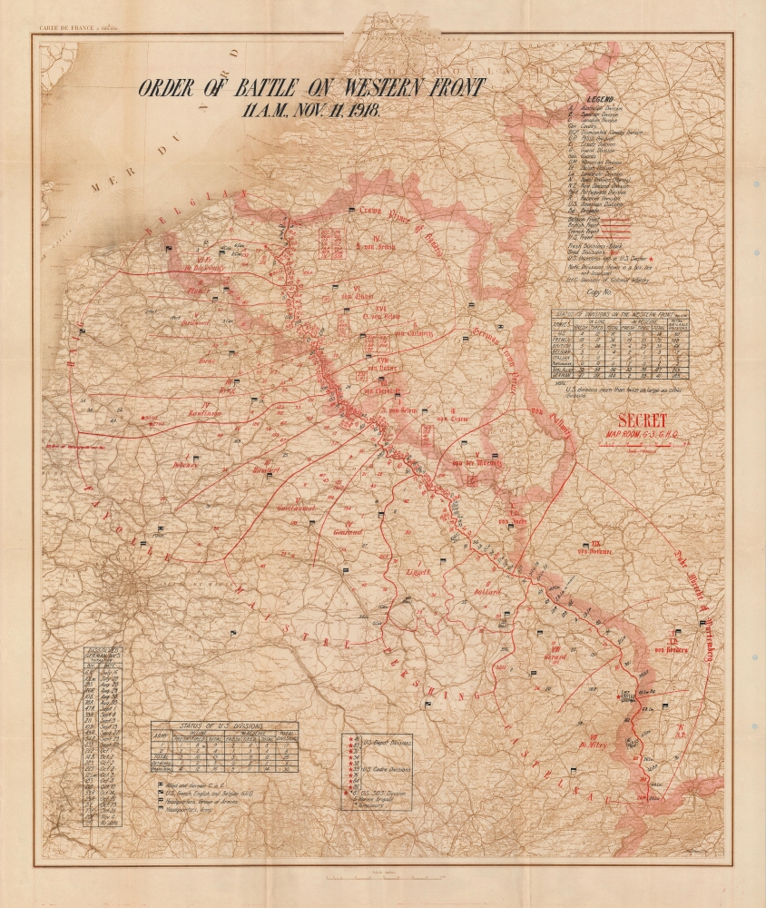
Order of Battle on Western Front 11 A.M., Nov. 11, 1918.
1918 (undated) 40.25 x 32.5 in (102.235 x 82.55 cm) 1 : 600000
1918 (undated) 40.25 x 32.5 in (102.235 x 82.55 cm) 1 : 600000
Description
This is a c. 1918 General Headquarters 'Secret' map of France, Belgium, Luxembourg, and parts of the Netherlands and Germany, depicting the Western Front on the when fighting stopped, ending World War I (November 11, 1918). The map records the 'eleventh hour of the eleventh day of the eleventh month' of 1918, when the armistice signed between the Allies and Germany at Compiègne, France, called for the cessation of hostilities on the Western Front. It was created in the Map Room of the Operations Section (G-3) of the General Headquarters staff on the contingency that German forces did not comply with the terms of the armistice and the war resumed. According to the Library of Congress, an example of this map was used at the Paris Peace Conference of 1919.
A Closer Look
'Secret' appears in bold red ink along the right border. The Western Front appears as a red line running from the English Channel to Switzerland. Sectors occupied by Allied countries are broadly labeled using the commanding general's last name (except for the Belgian sector): Haig, Fayolle, Maistre, Pershing, and Castelnau. Each sector is divided into smaller sectors with the commanding officer named. Numbers along both sides of the front line represent army divisions: Black numbers mark fresh divisions, while red indicates tired divisions. Abbreviations are used to identify divisions by nationality, along with other specific units, such as cavalry or guards. The German side of the front is given the same attention, with sector commanders and their subordinates identified. Red stars mark U.S. divisions outside the U.S. sector with flags defining headquarters.Armistice of November 11, 1918
World War I ended at 11 a.m. on November 11, 1918. The armistice was signed by Germany in a rail car near Compiègne, France, at 5:45 a.m. and went into effect at 11 a.m. Even though the armistice had been signed, fighting continued until 11 a.m., and 2,738 men were killed on that final day. Austria-Hungary, Bulgaria, and the Ottoman Empire had agreed to previous armistices, making Germany the last of the Central Powers to capitulate. The Treaty of Versailles, which officially ended the war between Germany and the Allies, was signed on June 28, 1919, and took effect on January 10, 1920. The following year, 1919, countries worldwide celebrated Armistice Day on November 11. Today in the United States we celebrate it as Veterans Day, so renamed in 1954.Publication History and Census
This map was created by J.C. Nichols and the G-3 (Operations) Map Room c. 1918. We note two cataloged examples: Library of Congress and the Osher Map Library at the University of Southern Maine. Two examples of the present map have entered the private market in the last 10 years, both at auction. There is a variant with slightly different overprinting held at the University of Virginia, with a note attached, 'This map is one of forty made by American General Headquarters'.Condition
Good. Wear along original fold lines. Closed margin tear professionally repaired on verso. Verso repairs and reinforcements at every fold intersection. Small areas of infill at a few fold intersections.
References
LCCN 2004627137. Library of Congress Call # G5701.S65 coll .B5. OCLC 936180429.