This copy is copyright protected.
Copyright © 2025 Geographicus Rare Antique Maps
Digital Image: 1852 Whitefield View of Williamsburg, Brooklyn
WilliamsburgBrooklyn-whitefield-1852_d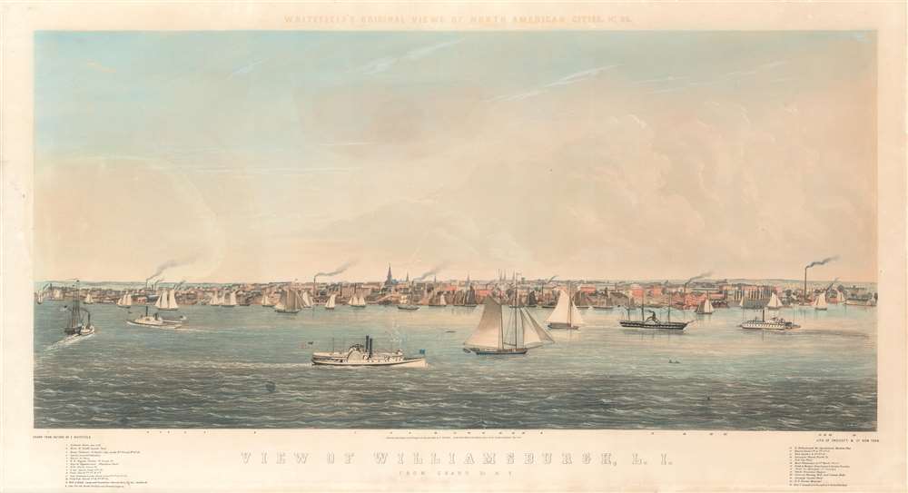

FOR THE ORIGINAL ANTIQUE MAP, WITH HISTORICAL ANALYSIS, CLICK HERE.
Digital Map Information
Geographicus maintains an archive of high-resolution rare map scans. We scan our maps at 300 DPI or higher, with newer images being 600 DPI, (either TIFF or JPEG, depending on when the scan was done) which is most cases in suitable for enlargement and printing.
Delivery
Once you purchase our digital scan service, you will receive a download link via email - usually within seconds. Digital orders are delivered as ZIP files, an industry standard file compression protocol that any computer should be able to unpack. Some of our files are very large, and can take some time to download. Most files are saved into your computer's 'Downloads' folder. All delivery is electronic. No physical product is shipped.
Credit and Scope of Use
You can use your digial image any way you want! Our digital images are unrestricted by copyright and can be used, modified, and published freely. The textual description that accompanies the original antique map is not included in the sale of digital images and remains protected by copyright. That said, we put significant care and effort into scanning and editing these maps, and we’d appreciate a credit when possible. Should you wish to credit us, please use the following credit line:
Courtesy of Geographicus Rare Antique Maps (http://www.geographicus.com).
How Large Can I Print?
In general, at 300 DPI, you should at least be able to double the size of the actual image, more so with our 600 DPI images. So, if the original was 10 x 12 inches, you can print at 20 x 24 inches, without quality loss. If your display requirements can accommodate some loss in image quality, you can make it even larger. That being said, no quality of scan will allow you to blow up at 10 x 12 inch map to wall size without significant quality loss. For more information, it is best consult a printer or reprographics specialist.
Refunds
If the high resolution image you ordered is unavailable, we will fully refund your purchase. Otherwise, digital images scans are a service, not a tangible product, and cannot be returned or refunded once the download link is used.
Edwin Whitefield Pennie (September 22, 1816 - December 26, 1892) was an English-American landscape painter active in the middle part of the 19th century. Whitefield was born in East Lulworth, England, the son of a Dorset schoolmaster. He emigrated to America, probably Canada, in 1835, leaving his first wife (Maria) and son in England. Some speculate that the move may been motivated by unwanted pressure from his family to embrace onerous medical or legal work. He taught school in Canada, and there married again, taking a second wife, Kate, who was probably one of his students. Seeking to develop as an artist, he moved to the United States around 1837 or 1838, establishing himself as an itinerant traveler/artist/journalist. He travelled up and down the Hudson, creating views of various American cities along the river, doing commission work, and selling lithographs of his work by subscription. This turned into a series of views of North American cities, of which there were at least 37, possibly more. Among the cities in his portfolio are views of Brooklyn, Toronto, Quebec City, Montreal, Ithaca, Jamestown, Poughkeepsie, Williamsburg (Brooklyn), Niagara, Philadelphia, Salem, Albany, and Boston, among many others. He separated from Kate, his Canadian wife, in 1853. Whitefield moved to Minnesota in 1856, settling in Kandotta with a new wife, Lillian, to engaged in land speculation. He had some success there, where Whitefield township, established in 1870, was named after him. Nearby Lake Lillian is named after his third American wife. He briefly lived in Chicago around 1861, before moving to Reading, Massachusetts in 1863 to paint the historic homes of New England, a project that he obsessed over until 1889, when the three-volume Homes of our Forefathers was finally published. In addition to his views, Whitefield is said to have published maps (we have not identified any), playing cards, and patented the Notosericum embroidery stamping technique. Whitefield returned to England in 1888, but returned to Massachusetts in 1892, settling in Roslindale, then in Dedham, where he died. More by this mapmaker...
Endicott and Company (fl. c. 1828 - 1891) was a New York based family run lithography firm that flourished throughout the 19th century. The firm was founded by George and William Endicott, brothers who were born in Canton, Massachusetts. George Endicott (June 14, 1802 - 1848) trained as a lithographer under Pendleton Lithography from January 1826. He later worked as superintendent of Senefelder Company until the summer of 1828. Afterwards, in 1830, he relocated to Baltimore and partnered with Moses Swett. Endicott and Swett relocated to New York City in December 1831. They remained partners until July 1834 when the relationship dissolved. George set up shop on his own account at 359 Broadway. William Endicott (1815 - 1851), George's younger brother of 14 years, joined the firm in 1840 and was made a partner in 1845, after which the name of the firm was changed to G. and W. Endicott. George Endicott died shortly afterward, in 1848, but William continued operating the firm as William Endicott and Co. until his own 1851 death at just 35 years old. The firm was carried on by his widow Sara Munroe Endicott until it was taken over by her son, Francis Endicott, who ran the firm from 1852 to 1886. George Endicott, Jr. subsequently ran the firm from 1887 to 1891. Peters, in his important work on American lithography America on Stone writes 'it is hard to summarize the Endicotts. They did everything and did it well . . . [they] worked with and for Currier and Ives, yet in spite of all that much of their work lacks real individuality.' The Endicott firm was responsible for many 19th century views and plans of New York City and state as well as plans of Sacramento, California, and the Midwest. Learn More...
Copyright © 2025 Geographicus Rare Antique Maps | Geographicus Rare Antique Maps
This copy is copyright protected.
Copyright © 2025 Geographicus Rare Antique Maps