1971 Los Angeles Planning Map of Western L. A. w/ Unbuilt Freeways
WilshireCirculation-laplanningdept-1971$900.00


Title
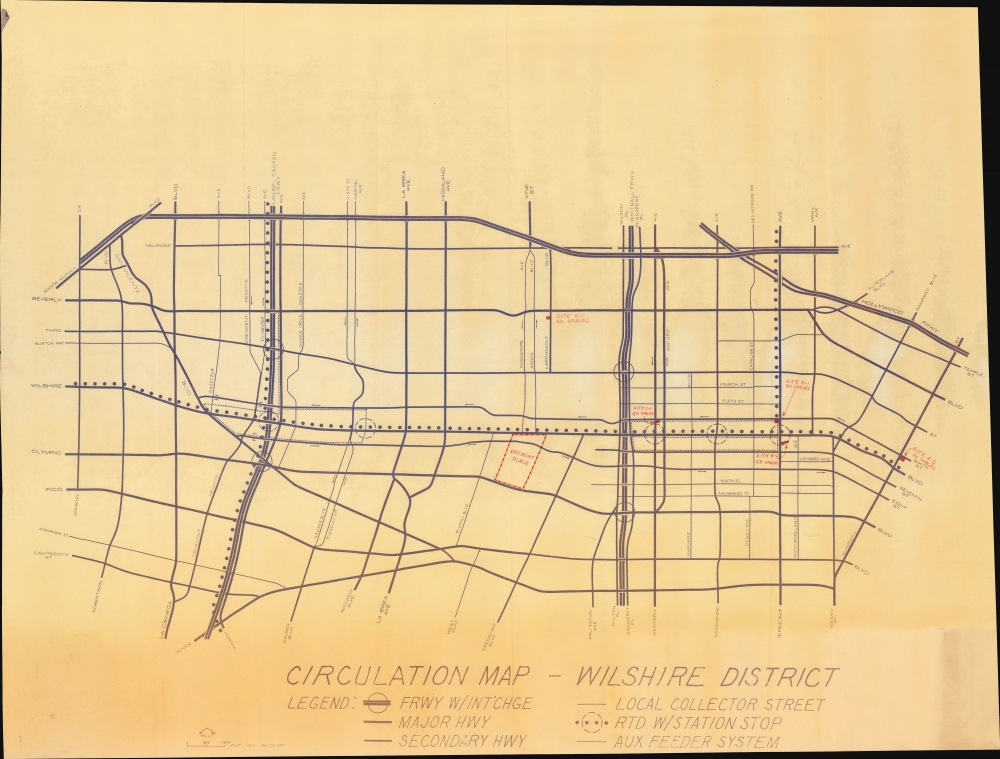
Circulation Map - Wilshire District.
1971 (dated) 31.75 x 51.25 in (80.645 x 130.175 cm) 1 : 9700
1971 (dated) 31.75 x 51.25 in (80.645 x 130.175 cm) 1 : 9700
Description
A unique and intriguing large-format 1971 map of the western portion of the city of Los Angeles, including Beverly Hills, produced by the city's Planning Department. It is especially interesting to consider the inclusion of three 'phantom freeways,' which were conceived but never built and which would have radically altered the neighborhoods traversed.
The failure of the Laurel Canyon, Whitnall, and Beverly Hills Freeway projects has helped to maintain the character and appeal of the neighborhoods that would have been impacted by the freeways. When this map was produced, many of these neighborhoods faced population loss and urban blight, with business owners welcoming the proposed freeways. But in the years after the map's production, the neighborhoods rebounded dramatically, thanks largely to immigrant communities, leading to the distinctive neighborhoods of Little Ethiopia, Litte Bangladesh, Koreatown, and the Latino Pico-Union neighborhood, among others. A string of museums (including the Los Angeles County Museum of Art, LACMA) and large housing projects along Wilshire Blvd. also helped to revive the area.
At the same time, the lack of major highways through the Westside has led to often maddening congestion on the highways that do exist, Interstate-10, Interstate-405, and the Hollywood Freeway (U.S.-101). In the coming years, LA Metro will be extending the Purple / D Line subway straight through this area to Westwood (largely following the route of the RTD bus on Wilshire Blvd. here), which ideally will help relieve traffic on Interstate-10 in particular.
A Closer Look
Coverage ranges from Doheny Drive in the west to Alvarado Street near downtown Los Angeles in the east and from Melrose and Santa Monica Boulevard in the north to Venice Boulevard in the south, taking in much of the west side of Los Angeles and part of Beverly Hills. Major roads and freeways, both extant and proposed, are labeled, along with RTD (Southern California Rapid Transit District) bus lines, proposed highway interchanges, and other features. Red print marks out Fremont Place, a posh, planned community built in the early 20th century, and sites for parking lots, with the number of spaces noted. The 'collector streets' and 'auxiliary feeder system' referred to in the legend appear, from contemporary planning publications, to be proposed rapid transit schemes for the mid-Wilshire area.Thwarted Highways
Most significantly, the map includes the never-built Laurel Canyon Freeway, Whitnall Freeway, and (not labeled) Beverly Hills Freeway. A small section of the Laurel Canyon Freeway was built in Baldwin Hills further to the south, but local opposition, including from movie stars and musicians in the Hollywood Hills, killed the project. The Whitnall Freeway, named for urban planner George Gordon Whitnall (1888 - 1977), who served as City Planner in the late 1920s, should not be confused with the Whitnall Highway, a road partially built back in the 1920s further to the east. The Beverly Hills Freeway (earlier called the 'Santa Monica Parkway') would have extended the Glendale Freeway (CA-2) westwards to link the Hollywood Freeway (U.S.-101) and Interstate-405, largely following the path of Santa Monica Boulevard. However, the project ran into fierce opposition from homeowners, and, as it was a state route rather than an interstate, funding difficulties arose. Although the state had secured right-of-way along much of the route, the Beverly Hills City Council, after years of support, came out against the project in 1971, the same year of this map's production, effectively killing the plan.An L.A. Exception
Los Angeles is famous for its freeways, which were mostly built between the 1930s and the late 1960s. However, one area conspicuously lacking in freeways is the city's west side, which is now one of the most densely populated parts of L.A. County. This is due to local opposition to the projects, part of a wider backlash against freeway construction in the late 1960s and early 1970s. In addition to the Laurel Canyon, Whitnall, and Beverly Hills Freeways, other freeway projects in Malibu and Pasadena were successfully opposed around the same time (though new projects in other, newly developed parts of L.A. County did go forward in the same period).The failure of the Laurel Canyon, Whitnall, and Beverly Hills Freeway projects has helped to maintain the character and appeal of the neighborhoods that would have been impacted by the freeways. When this map was produced, many of these neighborhoods faced population loss and urban blight, with business owners welcoming the proposed freeways. But in the years after the map's production, the neighborhoods rebounded dramatically, thanks largely to immigrant communities, leading to the distinctive neighborhoods of Little Ethiopia, Litte Bangladesh, Koreatown, and the Latino Pico-Union neighborhood, among others. A string of museums (including the Los Angeles County Museum of Art, LACMA) and large housing projects along Wilshire Blvd. also helped to revive the area.
At the same time, the lack of major highways through the Westside has led to often maddening congestion on the highways that do exist, Interstate-10, Interstate-405, and the Hollywood Freeway (U.S.-101). In the coming years, LA Metro will be extending the Purple / D Line subway straight through this area to Westwood (largely following the route of the RTD bus on Wilshire Blvd. here), which ideally will help relieve traffic on Interstate-10 in particular.
Publication History and Census
This map is dated as having been revised on January 25, 1971. No author or publication information is provided, but it was almost certainly prepared by the Los Angeles Department of City Planning. We have been unable to locate any other examples of this map in institutional holdings or on the market, though it is possible that the Planning Department or the City Archives and Records Center retain an example.Condition
Good. Toning. Light wear along original fold lines. Closed tears extending 1 and 1.5 inches respectively into printed area from bottom edge professionally repaired on verso. Close bottom and right edge.
References
Southern California Rapid Transit District, 'Rapid Transit for Los Angeles : Summary Report of Consultants' Recommendations' (Southern California Rapid Transit District, 1973).