This copy is copyright protected.
Copyright © 2025 Geographicus Rare Antique Maps
Digital Image: 1895 Goldmann Map of the Witwatersrand Gold Fields, Johannesburg
Witwatersrand-goldmann-1895_d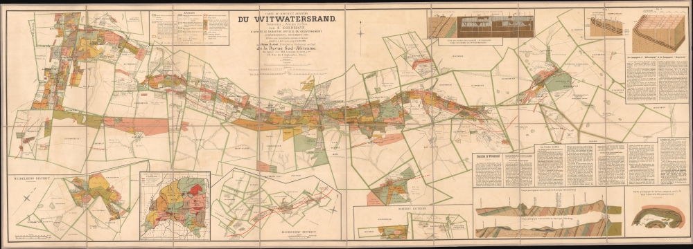

FOR THE ORIGINAL ANTIQUE MAP, WITH HISTORICAL ANALYSIS, CLICK HERE.
Digital Map Information
Geographicus maintains an archive of high-resolution rare map scans. We scan our maps at 300 DPI or higher, with newer images being 600 DPI, (either TIFF or JPEG, depending on when the scan was done) which is most cases in suitable for enlargement and printing.
Delivery
Once you purchase our digital scan service, you will receive a download link via email - usually within seconds. Digital orders are delivered as ZIP files, an industry standard file compression protocol that any computer should be able to unpack. Some of our files are very large, and can take some time to download. Most files are saved into your computer's 'Downloads' folder. All delivery is electronic. No physical product is shipped.
Credit and Scope of Use
You can use your digial image any way you want! Our digital images are unrestricted by copyright and can be used, modified, and published freely. The textual description that accompanies the original antique map is not included in the sale of digital images and remains protected by copyright. That said, we put significant care and effort into scanning and editing these maps, and we’d appreciate a credit when possible. Should you wish to credit us, please use the following credit line:
Courtesy of Geographicus Rare Antique Maps (http://www.geographicus.com).
How Large Can I Print?
In general, at 300 DPI, you should at least be able to double the size of the actual image, more so with our 600 DPI images. So, if the original was 10 x 12 inches, you can print at 20 x 24 inches, without quality loss. If your display requirements can accommodate some loss in image quality, you can make it even larger. That being said, no quality of scan will allow you to blow up at 10 x 12 inch map to wall size without significant quality loss. For more information, it is best consult a printer or reprographics specialist.
Refunds
If the high resolution image you ordered is unavailable, we will fully refund your purchase. Otherwise, digital images scans are a service, not a tangible product, and cannot be returned or refunded once the download link is used.
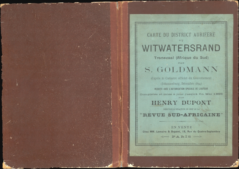
Charles Sydney Goldman (Goldmann) (April 28, 1868 - April 7, 1958) was British adventurer, businessman, author, journals, and politician primarily active in South Africa during the early late 19th and early 20th century. Goldman was a German Jew was born in the Cape Colony. He spent his early years in Germany, before moving to England and, ultimately, returning to the Cape Colony, where became extremely wealthy during the 1886 Witwatersrand Gold Rush. During the Boer War he enlisted as a Major and worked with Winston Churchill as a war correspondent for the Standard. After the First Boer War he focused on developing the gold resources of the Witwatersrand Ridge, preparing a highly detailed map of the region, illustrating gold claims, which was published in Paris in 1895. During the Second Boer War he was a special correspondent with Sir Redvers Buller in Natal and later with Lord Roberts on the South African Campaign. Also during the war, he married Agnes Mary Peel (1869–1959), a daughter of 1st Viscount Peel. After the British takeover of the Transvaal at the end of the Second Boer War, Goldman returned to England where he purchased The Outlook, a weekly sporting magazine, which he leveraged to garner political influence. In 1910, furthering his political ambitions, he ran for Parliament, taking the Penryn and Falmouth seat in a general election as a Unionist. During World War I he served as a major in the Cornwall Royal Garrison Artillery. Following the war, his Parliament seat was abolished and he again began to look to the colonies. In 1919, Goldman used part of his gold-mining fortune to purchase a vast tracking of land in British Columbia's Nicola Valley, which he named Nicola Stock Farm. He again returned to England living for a time at Trefusis House, in Falmouth, until roughly 1929, when he retired to the Jacobean estate of Yaverland Manor on the Isle of Wight. After a long and exciting life, Goldman died in British Columbia in 1958. More by this mapmaker...
Langonnet et Langlet (fl. 1885 - 1903) was a French firm established by the draughtsmen Langonnet et Langlet, who became partners in 1885. They created a special studio, which allowed them to produce more work than if they had worked on their own. They moved around Paris several times: from the Rue de Lancry to the Faubourg-Saint-Martin, before finally setting up shop at 124 and 126 Rue Lafayette in 1894. By 1900, they had fifteen draughtsmen working for them. Besides reproducing etchings, they also produced drawings meant to be reproduced by photo-lithography, helio-zincography, photogravure, and simili-gravure. The firm produced few maps, but did issue several important maps for the Revue Sud-Africaine and at last one of the Kondike gold region. Learn More...
Copyright © 2025 Geographicus Rare Antique Maps | Geographicus Rare Antique Maps
This copy is copyright protected.
Copyright © 2025 Geographicus Rare Antique Maps