Digital Image: 1867 Blanchard / Shober View of Wolf's Point, Chicago, in 1833
WolfsPointChicago-blanchard-1867_d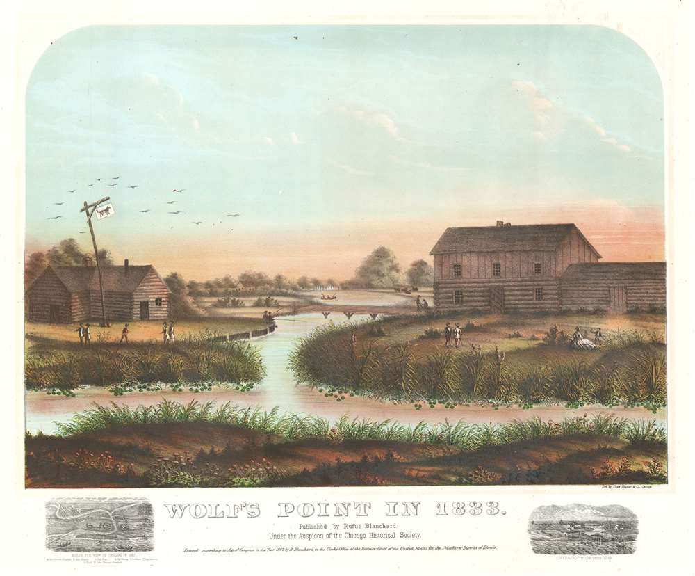

Title
Wolf's Point in 1833.
1867 (dated) 17 x 19.5 in (43.18 x 49.53 cm)
1867 (dated) 17 x 19.5 in (43.18 x 49.53 cm)
Description
FOR THE ORIGINAL ANTIQUE MAP, WITH HISTORICAL ANALYSIS, CLICK HERE.
Digital Map Information
Geographicus maintains an archive of high-resolution rare map scans. We scan our maps at 300 DPI or higher, with newer images being 600 DPI, (either TIFF or JPEG, depending on when the scan was done) which is most cases in suitable for enlargement and printing.
Delivery
Once you purchase our digital scan service, you will receive a download link via email - usually within seconds. Digital orders are delivered as ZIP files, an industry standard file compression protocol that any computer should be able to unpack. Some of our files are very large, and can take some time to download. Most files are saved into your computer's 'Downloads' folder. All delivery is electronic. No physical product is shipped.
Credit and Scope of Use
You can use your digial image any way you want! Our digital images are unrestricted by copyright and can be used, modified, and published freely. The textual description that accompanies the original antique map is not included in the sale of digital images and remains protected by copyright. That said, we put significant care and effort into scanning and editing these maps, and we’d appreciate a credit when possible. Should you wish to credit us, please use the following credit line:
Courtesy of Geographicus Rare Antique Maps (http://www.geographicus.com).
How Large Can I Print?
In general, at 300 DPI, you should at least be able to double the size of the actual image, more so with our 600 DPI images. So, if the original was 10 x 12 inches, you can print at 20 x 24 inches, without quality loss. If your display requirements can accommodate some loss in image quality, you can make it even larger. That being said, no quality of scan will allow you to blow up at 10 x 12 inch map to wall size without significant quality loss. For more information, it is best consult a printer or reprographics specialist.
Refunds
If the high resolution image you ordered is unavailable, we will fully refund your purchase. Otherwise, digital images scans are a service, not a tangible product, and cannot be returned or refunded once the download link is used.
Cartographer S
Rufus Blanchard Evanston (March 7, 1821 - January 3, 1904) was an American photographer, mapmaker, publisher, viewmaker, bookseller, and publisher active in Chicago in the second half of the 19th century. Blanchard was born in Lyndeborough, New Hampshire. He studied at Ipswich Academy showing proficiency in Latin and Mathematics. He relocated to New York in 1835 to live with this brother, Calvin Blanchard, who ran a book store at 78 Nassau St. He was present for both the New York Fire of 1835 and the Wall Street bank panic of 1836. Perhaps deciding the civilization was doomed, he moved to the backwoods of Ohio where he spent three years, bushwhacking, hunting, and trapping. Returning to New York in 1840, Blanchard took work with the Harper Brothers publishing house. The publishing business suited Blanchard, leading to his relocation to Lowell, Massachusetts in 1843 to open a bookshop. This business lasted just 3 years before the restless young man moved again, this time to Cincinnati, who he established another shop in connection with his brother Edwin Blanchard. Meeting some success here, he established an annex office in New Orleans. The Cholera epidemic of 1847-1848, followed by the great fire of St. Louis, unfortunately, devastated his interests in the region. He moved back to New York in 1849, briefly establishing a printing concern with Charles Morse, son of the famous inventor, and working with the J. H. Colton firm. He relocated to Chicago sometime before 1853, when he established in that city as a printer and publisher. He relocated his business to the railroad hub of Chicago (52 LaSalle Street) in 1854 to capitalize on the national need for good railroad maps. In 1857, he published Chicago's first street guide. In addition to his Chicago business, he also had an office in Wheaton, Illinois. His nephew, George Cram (1842 - 1928) joined his business in 1867, after being discharged from the Union Army, and they rebranded as 'Blanchard and Cram.' Both 'Blanchard and Cram' of Chicago and the Wheaton businesses were destroyed in 1871 - the main business by the Great Chicago Fire, and the Wheaton office, in a smaller fire. Nonetheless, Blanchard persevered, rebuilding both enterprises, although without Cram, who established his own firm, the George F. Cram and Company. In 1885 his business was again destroyed by fire, wherein he lost much of his map stock, but he again persevered and rebuilt. Blanchard's personal life was a notable for highs and lows as his business life. He first married in 1856, to Permilla Far (1829 - 1857). On their honeymoon, Permilla was severely injured, dying shortly thereafter, in 1857, from related complications. He remarried in 1858 to Anna E. Hall (1842 - 1925). Blanchard lived to 83, and during the entire time, continued to actively photograph, write, and publish. It is said that he 'never grew old in heart or brain.' More by this mapmaker...
Charles Shober (February 1831 - c. 1900) was a German-American lithographer and painter. Shober was born in Germany and immigrated to the United States in 1854. He established himself in Philadelphia, at 17 Minor Street, where fellow lithographers and map engravers George Worley and Benjamin Mathias, also worked. His first lithograph in America appeared in an 1855 issue of The Horticulturist. In 1857, he partnered with Charles Reen to establish 'Reen and Shober' at 5 South Sixth Street, Philadelphia. The partners relocated their business to Chicago (106 Lake Street) in 1859. Reen left the firm in 1859 and Charles took a new partner, August Roth, printing under the imprint of 'Charles Shober'. They met with considerable success, until 1871, when like many Chicago businesses, the Great Fire laid them low. After the fire, he took over management and partial ownership of the Chicago Lithographic Company, which had been founded some years earlier by Louis Kurtz and Edward Carqueville. Kurtz's interest in the firm was acquired by Shober and it was renamed 'Charles Shober and Company'. Sometime after 1876, the firm's name changed to 'Shober Lithograph Company', and then in 1877, to 'Shober and Carqueville Lithograph Company'. Despite infighting, the firm prospered, printing views, posters, maps, trade cards, and sheet music. In 1887, after a prolonged dispute with Carqueville, Shober left the firm. He traveled briefly then took a position as president of the Chicago Bank Note Company. Shober's son died in a tragic suicide in 1896, after which, Shober seems to have vanished from professional life. He appears in the Chicago directory as late as 1900. Learn More...
References
Library of Congress, PGA - Shober, Chas.--Wolf's Point in 1833 (B size) [P and P]. Deak, Gloria Gilda, Picturing America: 1497-1899, 419.