1628 Angelocrator Dual Octant Projection World Map: a Unique Work
World-angelocrator-1628$8,500.00


Title
Novum orbis terrarum schema, in plano sic descriptum, ut graduumtum circa polos dilatatio, tum circa aequatorem coarctatio excludatur.
1628 (undated) 11 x 20.75 in (27.94 x 52.705 cm) 1 : 100000000
1628 (undated) 11 x 20.75 in (27.94 x 52.705 cm) 1 : 100000000
Description
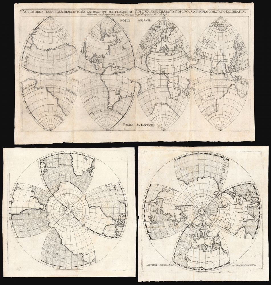
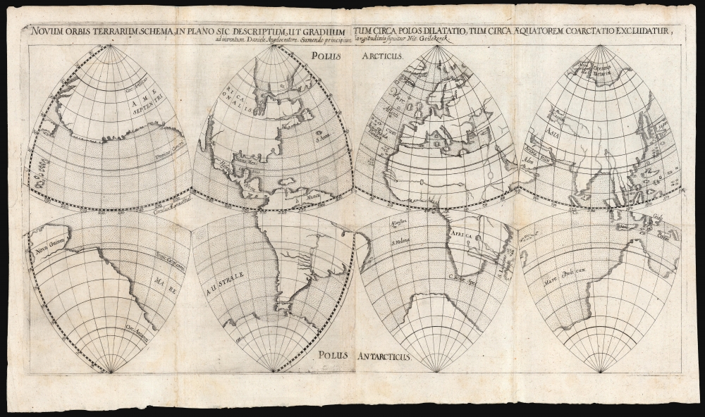
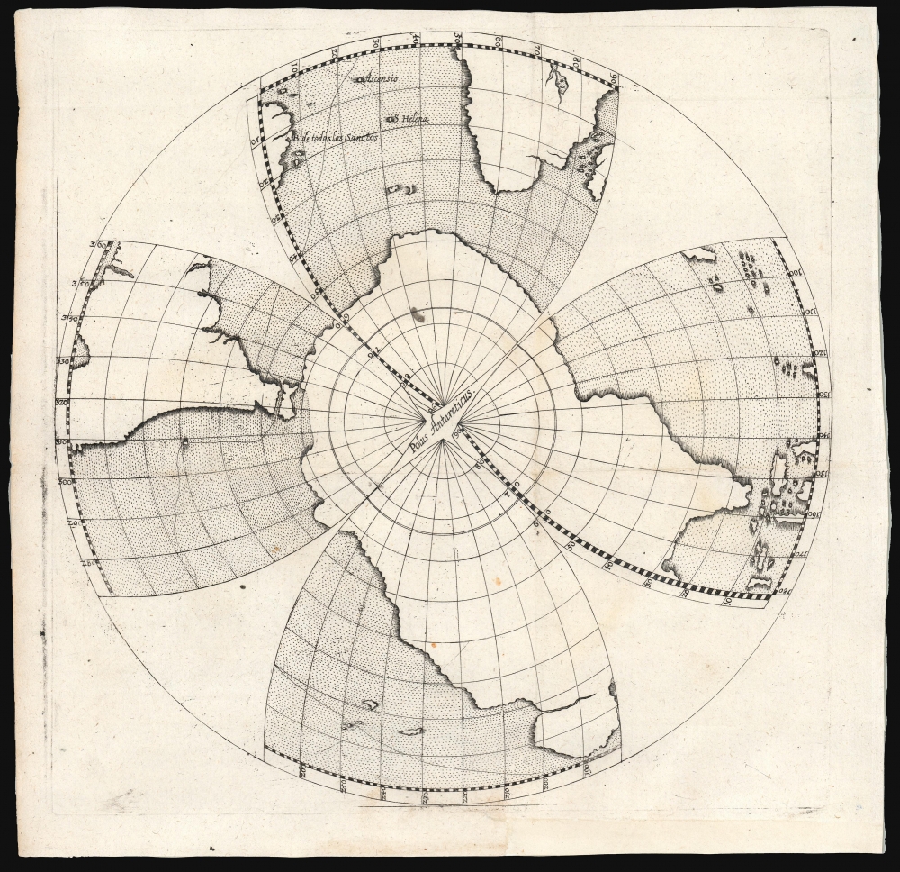
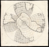
This rare, dual world map, projected in octants by Daniel Angelocrator in 1628, is among the most unique and distinctive 17th century depictions of the world.
A Closer Look
Angelocrator, in the title, cites Nicolas Geelkercken as the source for the map's topography. However, he took credit for the projection itself (despite its possible composition by Leonardo da Vinci and a mid-16th-century iteration by Oronce Fine.) Angelocrator seems to have sourced (or devised) this model because it avoided the distortion at the poles caused by the Mercator Projection. The four sheets presented here utilize the octant projection to present the world in two different ways. One pair, joined, presents the Western and Eastern Hemispheres in a manner similar to a double-hemisphere map. The other pair organizes the octants in polar projections. Angelocrator thus demonstrated that the octants could be reorganized, without substantial change, to show the world in equatorial or polar orientations without altering the projection - possibly an argument in their superiority over the Mercator projection, but also a keen illustration of the sphericality of the globe.The World in Outline
As Shirley notes, the map here includes little geographical detail: the continents are shown in outline, with few rivers and very few place names on the main map, and virtually none on the polar projections. This focus on the general outlines of the world's landmasses is consistent with Angelocrator's apparent object of simply illustrating his novel projection. Angelocrator included these maps, not in a geographical work, but in his Doctrina de Ponderibus, Monetis et Mensuris per Totum Terrarum Orbem Usitatis, a book discussing international weights and measures, coinage. They appeared explicitly in the context of his discussion of comparative measures of distance and the historical measures of the size of the globe (Eratosthenes, Ptolemy, Plato, and others.)Standard World Map of the Early 17th Century
The outline is partially derived from Geelkercken's 1617 map. Similar to that work, the North Atlantic includes Iceland and the phantom island of Frisland. The Southern Continent joins with New Guinea. Although the Geelkercken has Tierra del Fuego connecting to Antarctica, Angelocrator has separated these landmasses. Japan and Insular Korea also reflect their mapping on the 1617 source map. North America shows a peninsular California - although the Briggs and the Speed maps had been published by the time this map was printed, Angelocrator's model pre-dates the propagation of the California-as-an-island myth.Publication History and Census
This map was engraved for inclusion in the 1628 second edition of Daniel Angelocrator's Doctrina de Ponderibus, Monetis et Mensuris per Totum Terrarum Orbem Usitatis. We see only two examples of this map in institutional collections, both lacking the polar projections. The 1628 edition of the book is reasonably well represented in OCLC.CartographerS
Daniel Angelocrator (October 19, 1569 - July 30, 1635) was a German Reformed minister, theologian, and mapmaker. He was born Daniel Engelhardt in Korbach, and studied theology at the universities of Marburg and Franeker. Upon adopting Calvinism - a decision that caused a break with his family - he relocated to Geneva. In Switzerland, he taught in high schools; later, he became a minister in Germany. The Landgrave of Hesse-Kassel made him Archdeacon of Marburg in 1607. During this period, in 1617, he published the first edition of his book on weights and measures, 'Doctrina De Ponderibus, Monetis, et Mensuris per totum terrarum orbem usitatis' (Weights, Measures, and Coins Used Throughout the World.) He was a delegate to the Synod of Dort in 1618. The Thirty Years' War uprooted him from Hesse-Kassel, and he became minister of Gudensberg - only to be completely dispossessed by Imperial troops sacking the city in 1626. He relocated again in 1627 to Köthen. During his time there, he published a further edition of his Doctrina De Ponderibus, which contained a new world map Novum Orbis Terrarum Schema, in Plano sic Descriptum. Despite its likely invention by da Vinci, Angelocrator claimed the projection to be his own composition, while its geographical information was drawn from Geelkercken. He died in Köthen in 1635. More by this mapmaker...
Nicolaes van Geelkercken (ca. 1585 - 1656) was a Dutch surveyor, cartographer and publisher active in the early 17th century. He is thought to have begun his work as a cartographer, engraver, and colorist in the shop of Jodocus Hondius. Starting in 1610, he began producing maps to illustrate current conflicts of interest. In order to ensure that his news maps were up to date and accurate, Geelkercken was known to accompany the Dutch army on campaign. He was succeeded in his trade by his sons Isaac van Geelkercken, Jacob van Geelkercken and Arnold van Geelkercken. Learn More...
Source
Angelocrator, D., Doctrina de Ponderibus, Monetis et Mensuris per Totum Terrarum Orbem Usitatis, (Frankfurt: Stoltzenberger) 1628.
Condition
Very good. Mended well at folds of main map with slight reinstatement; two polar projections in fine condition. Measurements given for paired images joined.
References
OCLC 219877997 (lacking polar projections) Shirley, R., The Mapping of the World #320.