This item has been sold, but you can get on the Waitlist to be notified if another example becomes available, or purchase a digital scan.
1907 Bacon Folding Wall Map of the World
World-bacon-1907$550.00

Title
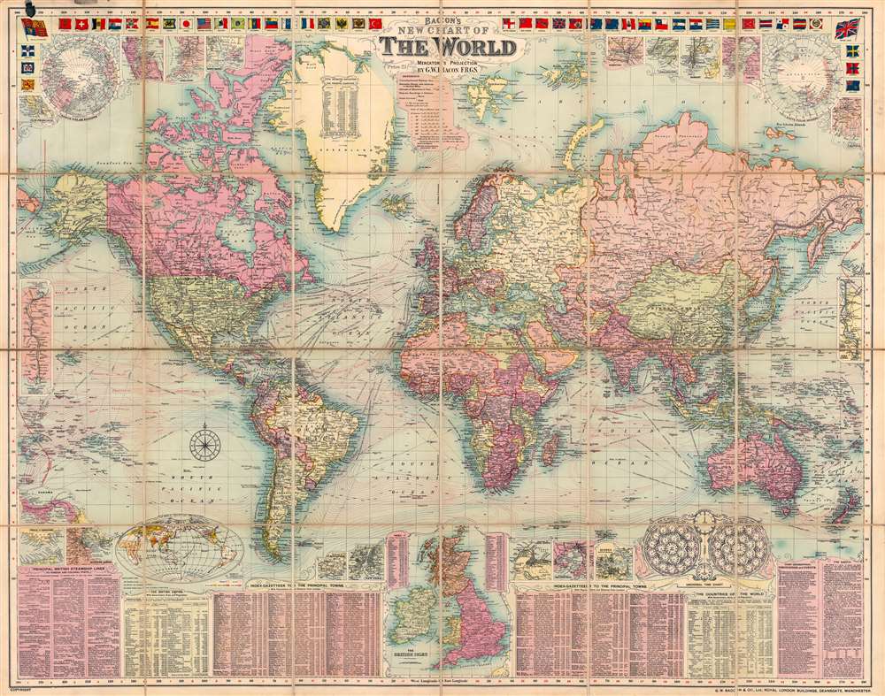
Bacon's New Chart of the World. Mercator's Projection.
1907 (undated) 37.5 x 47.5 in (95.25 x 120.65 cm) 1 : 38000000
1907 (undated) 37.5 x 47.5 in (95.25 x 120.65 cm) 1 : 38000000
Description
This is a visually striking 1907 George Washington Bacon map of the world on Mercator's projection. Bacon employs vivid color coding to highlight the colonial empires of Britain, France, Germany, and other world powers. The map also depicts ocean currents using an ingenious system of clustered red markings.
The Border Content
Bacon harnesses the extensive border space to offer rich supplementary content. Illustrations of 46 world flags create the top border. Nearly a dozen inset maps occupy the left and right corners and detail the polar regions, and the major cities of San Francisco, Hong Kong, Wellington, Tokyo, and Bombay. A table, occupying Greenland holds the estimated population of the world's principal countries. More insets along the latitudinal borders depict the Panama and Suez Canals. Another ten inset maps are included along the bottom, with the two largest mapping the British Isles and the world on an elliptical projection. Others detail the Strait of Gibraltar, Singapore, and New York City. Along the bottom, tables present the principal British steamship lines, parts of the British Empire, and the countries of the world. The largest table notes the principal cities of the world and provides information concerning each, including a short description, population, and grid location. A final chart explains time zones.Publication History and Census
This map was created and published by George Washington Bacon in 1907. Four examples are cataloged by the OCLC as being part of the institutional collection at Gettysburg College, the University of British Columbia, the National Library of Wales, and the National Library of Australia. The map appeared in many editions, but early editions, as here, are scarce to the market.Cartographer
George Washington Bacon (1830 - 1922) was a London based book and map publisher active in the mid to late 19th century. Bacon's firm G.W. Bacon and Co. purchased the plates created by Edward Weller for the Weekly Dispatch Atlas then modified and updated them for several of their own important atlases, including The New Ordnance Atlas of the British Isles. In 1893, Bacon & Co. acquired the map publishing business of J. Wyld. Then, around the turn of the century, Bacon & Co. itself was folded into the Scottish publishing house of W.& A.K. Johnston. More by this mapmaker...
Condition
Very good. Dissected and mounted on linen in 24 panels. Minor discoloration to upper left corner.
References
OCLC 1119893981.