1759 Homann Heirs Map of the World, with Müller's North Pacific Geography
World-homannheirs-1759$1,500.00
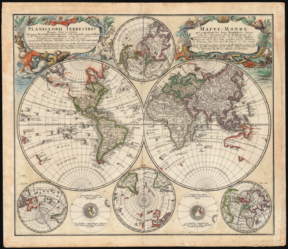

Title
Planiglobii Terrestris/ Mappe-Monde.
1759 (dated) 17.75 x 21 in (45.085 x 53.34 cm) 1 : 96,000,000
1759 (dated) 17.75 x 21 in (45.085 x 53.34 cm) 1 : 96,000,000
Description
This is an elegant and detailed 1759 world map by Johann Matthias Hase and Georg Maurice Lowitz, contributors to the firm of Homann Heirs. The map was first issued in 1746, reflecting the best available cartographic detail of the day both from French and Russian sources. The present example was updated c. 1759 to reflect the discoveries of Bering and Chirikov according to the 1754 Müller map, confirming the separation of the continents of Asia and North America.
The sea between Korea and Japan appears here as 'Mare Oriental Minus' (The Lesser Eastern Sea).
Müller's Updates
The 1746 edition of this map showed a vast, unmarked space between the North American coast at about 45° North and the northeast of Russia at the Arctic Circle. Here, this has been significantly updated to include the detail revealed in Gerhard Friedrich Müller's 1754 Nouvelle Carte Des Decouvertes Faites Par Des Vaisseaux Russess Aux Cotes Inconnues De L'Amerique Septentrionale. Müller's map was the first to reveal the discoveries of Bering and Chirikov, and while Homann's map does not include their voyages' tracks, the combination of their reported discoveries and the speculative lands connecting them hails from Müller. That map, as here, indicated the coastline found by Gvosdev in 1730. The inclusion of this new cartography is particularly significant in that it confirmed for the first time, based on observation, that Asia and North America were separate continents.An Elegant, Up-to-Date Map
The map blends rich decorative flourish and abundant scientific detail. Even the cartouches, hitherto a visual arena for allegory and political favor, here celebrate the natural world, including depictions of coral likely derived from the 1731 work of Englishman Mark Catesby. Cartographically, the map encapsulates the best mapping of the world before the voyages of Cook. Australia and New Zealand rely on Tasman's reports of the previous century. North America reflects De l'Isle's mapping of the Mississippi, the Great Lakes, and the West Coast, including a peninsular California.The sea between Korea and Japan appears here as 'Mare Oriental Minus' (The Lesser Eastern Sea).
The Subordinate Charts
In addition to the main hemispheres, the map includes an array of smaller hemispheres derived from earlier work by Lowitz. These include northern and southern projections, as well as two projections centered on Nuremberg and its antipodes. Two additional diagrams illustrate the parts of the globe directly illuminated by the Sun at the winter and summer solstices and its presumed effect on the thickness of the atmosphere.Publication History and Census
This map was first engraved for inclusion in Homann Heirs atlases in 1746. According to C. Sandler in Johann Baptista Homann, die Homännischen Erben, Matthäua Seutter und Ihre Landkarten, Homann Heirs printed a Planiglobium both in 1746 and in 1759. It is reasonable to assign that latter date to this state of the map, although there were also later printings of the Homann Heirs atlases, and later editions of this map may exist. The map appears on the market in both its 1746 and its later states with some regularity, but since it is virtually always erroneously cataloged with the 1746 date without regard to the map's content, it is difficult to determine the relative scarcity of its states.CartographerS
Homann Heirs (1730 - 1848) were a map publishing house based in Nuremberg, Germany, in the middle to late 18th century. After the great mapmaker Johann Baptist Homann's (1664 - 1724) death, management of the firm passed to his son Johann Christoph Homann (1703 - 1730). J. C. Homann, perhaps realizing that he would not long survive his father, stipulated in his will that the company would be inherited by his two head managers, Johann Georg Ebersberger (1695 - 1760) and Johann Michael Franz (1700 - 1761), and that it would publish only under the name 'Homann Heirs'. This designation, in various forms (Homannsche Heirs, Heritiers de Homann, Lat Homannianos Herod, Homannschen Erben, etc..) appears on maps from about 1731 onwards. The firm continued to publish maps in ever diminishing quantities until the death of its last owner, Christoph Franz Fembo (1781 - 1848). More by this mapmaker...
Johann Matthias Hase (January 14, 1684 - September 24, 1742) was a German cartographer, historical geographer, mathematician, and astronomer. Born in Augsburg, Hase was the son of a mathematics teacher, thus exhibited skill at mathematics early in life. He began attending the University of Helmstedt in 1701, where he studied mathematics under Rudolf Christian Wagner and then moved to the University of Leipzig to pursue a master's degree. He received his master's in 1707 and promptly returned to Augsburg to work as a teacher. However, he soon returned to Leipzig to serve as court master for two Augsburg patricians. There he became increasingly involved with geography, astronomy, and cartography as adjunct to the philosophical faculty. Hase was recommended for the position of chair of higher mathematics at the University of Wittenberg by his former professor, Christian Wolff, in 1715, but he was rejected. Five years later in 1720, however, he was named Professor of Mathematics at the University of Wittenberg. It is unclear exactly when Hase began working with the Homann Heirs firm, but he Hase compiled numerous maps under that imprint. He was also a prolific writer, publishing several treatises on universal history. Learn More...
Georg Maurice Lowitz (1722 - 1774) was a German cartographer, astronomer and professor of mathematics. His youth is not documented, but his parents were Wolfgang Lowitz and Catherine Lobits. He was director of the observatory at Göttingen for a timne. In 1766 he travelled to Saint Petersburg, Russia, to join the Academy of Sciences. He observed the 1769 transit of Venus from Gureyev (modern Atyrau) north of the Caspian Sea. During the 1773-75 Pugachev Rebellion he was employed by Russia in making surveys to construct a canal between the Volga and the Don rivers when he was captured by Pugachev's Cossacks, and killed. Learn More...
Gerhard Friedrich Müller (Фёдор Ива́нович Ми́ллер; October 29, 1705 - October 22, 1783), also known as Fyodor Ivanovich Miller, was a Russian-German historian, ethnologist and cartographer. He was born in Herford and educated at Leipzig. In 1725, he was among the European scholars invited to St. Petersburg to co-found the Imperial Academy of Sciences. Müller took part in the Academy's Great Northern Expedition (Second Kamchatka Expedition; 1733 - 1743), he and eighteen scientists and artists traveled the area to perform ethnological and botanical studies, as well as collecting data for the creation of maps. Müller's descriptions and categorizations of clothing, religions and rituals of the Siberian ethnic groups earned him the title 'father of ethnography.' He produced an essential map of the arctic and sub-arctic regions of the Pacific in 1754, motivated to counter the geographic frauds perpetrated by Joseph Nicholas De l’Isle (1688 - 1768) and Phillippe Buache (1700 - 1773). He knew both Vitus Bering (1733 - 1743) and Aleksei Chirikov (1703 - 1748), and was as close to his subject matter as any cartographer of his age. Learn More...
Source
Atlas Geographicus, (Nuremberg: Homann Heirs) 1759.
Condition
Very good. Some areas of soiling; few mends in margin and at centerfold not impacting image.
References
OCLC 1145851612.