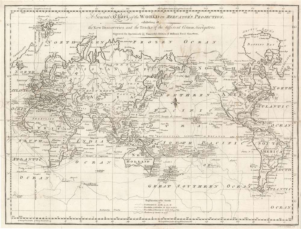
Title
A General Chart of the World on Mercator's Projection, exhibiting all the New Discoveries and the Tracks of the different Circum-Navigators. Engraved for Spotswood's and Nancrede's Edition of Malham's Naval Gazetteer.
1797 (undated)
13.25 x 17.5 in (33.655 x 44.45 cm)
1 : 87700000
Description
This 1797 map of the world by John Norman is one of the few printed in America prior to the 19th century. It was published in Boston for the first edition of Reverend John Malham's Naval Gazetteer. The map was engraved by John Norman, one of the first American mapmakers, of whose cartographic output virtually all ranks among the rarest and most sought-after nautical charts of the 18th century. It illustrates the routes of nautical explores, speculative routes through North America, names the Sea of Korea, and the legendary Chinese colony of Fusang.
Recording Important Discoveries
Though this chart is indeed presented on the Mercator projection as its title advertises, it is unusual for such a map in that it is centered on the Pacific Ocean rather than the Atlantic, as is more typical for maps following this projection. This peculiar focus is chosen in order to better depict the array of explorers' tracks shown on the map, primarily those of Captain Cook. A key at bottom identifies the tracks of his voyages aboard Endeavour, the Resolution and Adventure, and his final voyage with Resolution and Discovery. There is a notation of his death on Hawaii. There is a further expedition noted: John Phipps' 1773 voyage aboard the HMS Racehorse and HMS Carcass, an attempt at finding the then-elusive northwest passage.
Phipps' lack of success notwithstanding, the question of the northwest passage is left open on this map (though not explicitly depicting any such route). The Pacific coast of North America is left undefined, as is most of the Arctic coast of the continent. A 'River of the West' appears to the east of Nootka Sound, also hinting at an easy route inland. Fusang
Along the coast of modern-day British Columbia, in an unexplored zone identified by a ghosted lines, the postulated Chinese colony of Fusang is identified. Fusang or Fousang is a region first documented by the Chinese Buddhist missionary Hui Shen in the 5th century. Hui Shen describes a land some 20,000 Chinese Li (c. 8000 km) east of the China coast. Fousang is described in considerable detail in the 7th century Book of Liang by Yao Silian. There are also accounts that the land was settled c. 220 BC by a Chinese Emperor of the Han Dynasty. In later days Fusang was commonly used in Chinese poetry to designate Japan, however earlier references keep it distinct. In any case, Hui Shen's description of Fusang with regard to distance and geography corresponds more with the coastlands of North America than with Japan. The French historian Joseph de Guignes in his 1761 article Le Fou-Sang des Chinois est-il l'Amerique? promoted this idea. Cartographers of the era, including Buache de Neuville, Zatta, Robert de Vaugondy, and others, embraced the idea and it was included in many subsequent maps of the region. Sea of Korea vs. Sea of Japan
The sea between Japan and Korea, whose name, either the 'Sea of Korea,' 'East Sea,' or the 'Sea of Japan,' is here identified in favor of Korea (Mer de Coree). Historically, Korea has used the term 'East Sea' since 59 B.C., and many books published before the Japanese annexed Korea make references to the 'East Sea' or 'Sea of Korea.' Over the centuries, neighboring and western countries have identified Korea's East Sea using various different terms. The St. Petersburg Academy of Sciences referred to the East Sea as 'Koreiskoe Mope' or 'Sea of Korea' in their 1745 map of Asia. Other seventeenth and 18th century Russian maps alternate between 'Sea of Korea' and 'Eastern Ocean.' The 18th century Russian and French explorers Adam Johan von Krusenstern and La Perouse called it the 'Sea of Japan,' a term that became popular worldwide. Nonetheless, the last official map published by the Russians name the East Sea the 'Sea of Korea.' The name is currently still a matter of historical and political dispute between the countries.Publication History
Norman's engraved map appeared in the Boston edition of Rev. John Malham's Naval Gazetteer. Phillips does not show any further iteration of the map in the 1812 Philadelphia edition of the book.
Cartographer
John Norman (1748 - June 8, 1817) was an engraver and publisher in Boston, Massachusetts. Born in England, he apprenticed as a printer under the elder William Faden, father of the mapmaker William Faden II (1749 - 1836). Norman completed his apprenticeship in October of 1773 and shortly thereafter moved to Philadelphia. There he established himself as an engraver, publishing his first map The Theatre of War in North America in 1777. He relocated to Boston in 1781. He is best known for nautical charts, many of which represent the earliest American-produced sea charts of the areas depicted, and are consequently among the most important American printed works of the 18th century. Norman had engraved two of the charts for the first American nautical atlas (Mathew Clark’s 1790 A Complete Set of Charts of the Coast of America). The success of this venture inspired Norman to publish is own atlas in 1791, The American Pilot. This is one of the most important American atlases, and loose examples of Norman’s charts are extremely rare on the market. Norman’s work includes portraits, illustrations and architectural diagrams; he also produced maps for publication in works such as Boston Magazine and Malham’s Naval Gazetteer. He died of typhoid in 1817. His son, William Norman (17?? - 1807) began working with him and fully took over publication of the The American Pilot around 1794. More by this mapmaker...
Source
Malham, Rev. John. The naval gazetteer. 1st American ed. 8°. Boston, W. Spotswood & J. Nancrede, 1797
Condition
Good. Mends at margins, folds, and insertion point. No text on verso.
References
Wheat, J.C., and Brun, C. F., Maps and Charts Published in America before 1800; a Bibliography, 35. Phillips ( America) 1095.